Quirino Avenue
President Elpidio Quirino Avenue, more commonly known as Quirino Avenue, is a 6-10 lane divided highway in Manila, Philippines. It runs for 3.6 kilometers (2.2 miles) in a northeast-southwest direction from Nagtahan Bridge (now Mabini Bridge) across from Santa Mesa in the north to Roxas Boulevard in Malate in the south. It passes through Paco and Pandacan districts where it also serves as a truck route between Port Area and South Luzon Expressway. North of Nagtahan Bridge, the road continues as Nagtahan Street. It is designated as part of Circumferential Road 2.
.svg.png.webp) C-2 | |
|---|---|
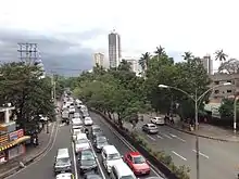 Looking west towards Malate from Quirino LRT Station | |
| Namesake | Elpidio Quirino |
| Maintained by | Department of Public Works and Highways - South Manila District Engineering Office[1] and Metro Manila Development Authority |
| Length | 3.6 km (2.2 mi) |
| Component highways |
|
| Location | Manila |
| North end | Paz Mendoza Guazon Street & Jesus Street in Paco |
| Major junctions |
|
| South end | |
Route description
- Nagtahan Bridge to Paco-Santa Mesa Road section
The northern end of Quirino Avenue is at the intersection of Paz Mendoza Guazon (Otis) and Jesus Streets in Paco, at the foot of the Nagtahan Bridge as a continuation of Nagtahan. Jesus Street leads to the former Pandacan oil depot to the east while Paz Mendoza Guazon Street leads to Malacañang Park and Robinsons Otis to the west. Heading south, it enters Pandacan district moving past primarily residential areas on both sides, with Zamora Market on the west side. The avenue then curves southwest following the alignment of the Philippine National Railways line, where it merges with traffic from Paco-Santa Mesa Road (Tomas Claudio Street).
- Paco-Santa Mesa Road to Osmeña Highway section

South of the junction with Tomas Claudio, the avenue traverses the district of Paco where the Old Paco station and Plaza Dilao are located. Also located along this stretch are the Philippine Columbian Association complex on Plaza Dilao and the new Paco railway station near the intersection with Pedro Gil Street. It follows a straight path south towards the border with Malate where it is joined by Osmeña Highway (South Luzon Expressway).
- Osmeña Highway to Roxas Boulevard section
The Malate section of Quirino Avenue is primarily residential and commercial. The Singalong area lies directly south of the Osmeña Highway junction just before it intersects with Taft Avenue, where the elevated Quirino LRT Station is located. South of Taft Avenue, Quirino provides access to the tourism center of Malate where the Remedios Circle, Manila Zoo, Baywalk, San Andres Sports Complex, Plaza Rajah Sulayman, and Malate Church are located. It curves westwards past Adriatico Street until it meets its southern terminus at Roxas Boulevard near Manila Yacht Club and Ospital ng Maynila Medical Center.
- Quirino Avenue Extension
| |
|---|---|
| Location | Manila |
.svg.png.webp)
Quirino Avenue extends to the industrial area of Paco (Otis) and United Nations Avenue from a loop road around Plaza Dilao just off the main highway on the north side of its short Paco segment. This is the main truck route going in and out of Port Area from South Luzon Expressway.
History
Its construction dates back to the early 19th century under Spanish rule when Quirino Avenue Extension was first laid out as Calle Canonigo in Paco.[2] The road leading to Nagtahan Bridge then was a narrow street called Calle Luengo in Pandacan.[3]
By the late 1920s, under the United States' Insular Government, the road from Plaza Dilao to the Pasig River across from Santa Mesa was constructed which was later named Tomás Claudio Street (also Paco–Santa Mesa Road) after the Filipino World War I hero, Tomas Mateo Claudio.[4] Following the Burnham Plan for Manila, the road was further extended south to meet Harrison Boulevard that ran southwest from Calle Herrán (now Pedro Gil Street) up to Dewey Boulevard (now Roxas Boulevard). The whole length of the highway that forms part of Circumferential Road 2 was later named in honor of the sixth President of the Philippines, Elpidio Quirino.
Landmarks


- Aloha Hotel
- Asociacion de Damas de Filipinas
- Bureau of Plant Industry
- Jacinto Zamora Elementary School
- Manila Zoological and Botanical Garden
- Old Paco railway station
- Ospital ng Maynila Medical Center
- Malacañang Hospital
- Manuel Roxas High School
- Paraiso ng Batang Maynila Park
- Philippine Columbian Association
- Plaza Dilao
- President Elpidio Quirino Monument
- Saint Peter the Apostle School
- San Andres Market
- Zamora Market
Intersections
Quirino Avenue
The entire route is located in Manila.
| km | mi | Destinations | Notes | ||
|---|---|---|---|---|---|
| Northern terminus. Continues north as | |||||
| Gonzales Street | Southbound only. | ||||
| P. Quirino Bridge | |||||
| Skyway | Skyway-Nagtahan Exit. Future northbound entrance from Skyway Stage 3. | ||||
| East Zamora Street | Traffic light intersection. | ||||
| Paradise Street | Northbound only. | ||||
| Skyway | Skyway-Nagtahan Exit. Future southbound exit to Skyway Stage 3 northbound. | ||||
| Obisis Street | Southbound only. | ||||
| Carlos Street Extension | Northbound only. | ||||
| West Zamora Street | Traffic light intersection. | ||||
| San Jose Street | Northbound only. | ||||
| E. Carlos Street | Northbound only. | ||||
| Northbound only. Access from southbound side via U-Turn slot. | |||||
| Concordia Bridge | |||||
| Skyway | Skyway-Plaza Dilao Exit. Southbound exit. Partially opened as of July 22, 2019.[5] | ||||
| Northbound exit, southbound exit, and southbound entrance only. Access to Quirino Avenue Extension, United Nations Avenue, and Paz Mendoza-Guazon Street. | |||||
| Santo Sepulcro Street | Southbound only. | ||||
| Figueroa Street | One-way. No entry from Quirino Avenue. | ||||
| Pedro Gil Street | Traffic light intersection. No right turn allowed from southbound and no left turn allowed from northbound. | ||||
| Sagat Street | One-way. Southbound only. | ||||
| Traffic light intersection. Access to | |||||
| Union Street, Lanuza Street | Southbound only; Union Street is one-way | ||||
| Paz Street | Southbound only. | ||||
| P. Quirino Bridge | |||||
| Skyway | Skyway-Quirino Exit. Future northbound exit towards Skyway Stage 3. Future access to | ||||
| Anak Bayan Street, Julio Nakpil Street, Mataas na Lupa Street | Traffic light intersection. | ||||
| Campillo Street | Northbound only | ||||
| Angel Linao Street | Traffic light intersection. One-way road. | ||||
| Pintong Bato Street | Southbound only. | ||||
| Smith Street | Northbound only | ||||
| Singalong Street | Traffic light intersection. One-way road. | ||||
| San Bartolome Street | Limited access road. Southbound only. | ||||
| F. Benitez Street | One-way road. Both segments accessible thru nearby intersections. | ||||
| Modesto Street | Both segments accessible thru nearby intersections. | ||||
| Traffic light intersection. One-way road. | |||||
| San Pascual Street, Agoncillo Street | Both segments accessible thru nearby intersections. | ||||
| San Antonio Street | Northbound only. | ||||
| Leon Guinto Street | Traffic light intersection | ||||
| San Andres Street | One-way road going in opposite directions. Bisected by Taft Avenue. | ||||
| Traffic light intersection. | |||||
| Fidel A. Reyes Street, Maginhawa Street, Bagong Lipunan Street | Northbound only. | ||||
| Leveriza Street | Traffic light intersection. | ||||
| Camia Street, Asuncion Street | Northbound only. | ||||
| Adriatico Street | Traffic light intersection | ||||
| Madre Ignacia Street | Unsignaled intersection | ||||
| Apolinario Mabini Street | Traffic light intersection. Northern segment is one-way only. | ||||
| Southern terminus. Access to Pasay, Parañaque, Cavite to the south; Port Area, Intramuros and Tondo districts to the north. | |||||
1.000 mi = 1.609 km; 1.000 km = 0.621 mi
| |||||
Quirino Avenue Extension
The entire route is located in Manila.
| km | mi | Destinations | Notes | ||
|---|---|---|---|---|---|
| Southern terminus | |||||
| San Antonio Street | One-way entrance only | ||||
| San Gregorio Street | Southbound only | ||||
| Peñafrancia Street, Zamora Street | Traffic light intersection | ||||
| Peñafrancia Extension | Northbound only | ||||
| Zulueta Street | Southbound only | ||||
| Paz Street | Unsignalled intersection | ||||
| Cristobal Street | Southbound entrance only | ||||
| Northern terminus. Traffic light intersection. | |||||
| 1.000 mi = 1.609 km; 1.000 km = 0.621 mi | |||||
See also
- Major roads in Manila
References
- "South Manila". Retrieved May 23, 2020.
- History of San Fernando de Dilao Archived 2013-07-24 at the Wayback Machine published by the Roman Catholic Archdiocese of Manila; accessed October 9, 2013.
- 1945 Map of Central Manila published by BattleofManila.org; accessed October 9, 2013.
- Briones, A.G. (1955). AB Commercial Directory of the Philippines. University of California. Retrieved 5 February 2017.
- Santos, Tina G. "Buendia-Plaza Dilao part of Skyway opens". newsinfo.inquirer.net.
| Wikimedia Commons has media related to Quirino Avenue. |