Parachute, Colorado
The Town of Parachute is a Home Rule Municipality in Garfield County, Colorado, United States. The population was 1,085 at the 2010 census.[8]
Parachute, Colorado | |
|---|---|
 Parachute in 2013 | |
| Motto(s): "Western Gateway to the Rockies"[1] | |
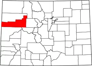
 Location of Parachute in Garfield County, Colorado. | |
| Coordinates: 39°27′6″N 108°3′6″W | |
| Country | United States |
| State | Colorado |
| County | Garfield County[2] |
| Incorporated | 1908-04-01, as the Town of Grand Valley[3] |
| Government | |
| • Type | Home Rule Municipality[2] |
| • Mayor | Roy McClung |
| Area | |
| • Total | 1.87 sq mi (4.85 km2) |
| • Land | 1.81 sq mi (4.68 km2) |
| • Water | 0.07 sq mi (0.17 km2) |
| Elevation | 5,092 ft (1,552 m) |
| Population (2010) | |
| • Total | 1,085 |
| • Estimate (2019)[6] | 1,116 |
| • Density | 617.94/sq mi (238.53/km2) |
| Time zone | UTC-7 (Mountain (MST)) |
| • Summer (DST) | UTC-6 (MDT) |
| ZIP codes[7] | 81635, 81636 (PO Box) |
| Area code(s) | 970 |
| FIPS code | 08-57400 |
| GNIS feature ID | 2413110 [5] |
| Website | www |
The town is the birthplace of Willard Libby, recipient of the 1960 Nobel Prize in Chemistry.
Geography
Parachute is on the northwest side of the Colorado River where it is joined by Parachute Creek. Interstate 70 passes through the town, with access from Exit 75. I-70 leads east 42 miles (68 km) to Glenwood Springs, the county seat, and southwest 44 miles (71 km) to Grand Junction. Parachute is bordered to the southeast across the Colorado River by the unincorporated community of Battlement Mesa.
According to the United States Census Bureau, the town has a total area of 1.67 square miles (4.32 km2), of which 1.61 square miles (4.16 km2) is land and 0.062 square miles (0.16 km2), or 3.70%, is water.[8]
Climate
This climatic region is typified by large seasonal temperature differences, with warm to hot (and often humid) summers and cold (sometimes severely cold) winters. According to the Köppen Climate Classification system, Parachute has a humid continental climate, abbreviated "Dfb" on climate maps.[9]
| Climate data for Parachute | |||||||||||||
|---|---|---|---|---|---|---|---|---|---|---|---|---|---|
| Month | Jan | Feb | Mar | Apr | May | Jun | Jul | Aug | Sep | Oct | Nov | Dec | Year |
| Average high °C (°F) | 3 (38) |
8 (46) |
13 (56) |
18 (64) |
24 (76) |
31 (88) |
34 (94) |
34 (93) |
28 (82) |
19 (66) |
11 (51) |
5 (41) |
19 (66) |
| Average low °C (°F) | −12 (11) |
−7 (19) |
−2 (29) |
1 (33) |
6 (43) |
10 (50) |
14 (58) |
14 (57) |
9 (48) |
2 (35) |
−3 (27) |
−8 (18) |
2 (36) |
| Average precipitation mm (inches) | 18 (0.7) |
18 (0.7) |
46 (1.8) |
43 (1.7) |
30 (1.2) |
25 (1) |
38 (1.5) |
23 (0.9) |
36 (1.4) |
51 (2) |
43 (1.7) |
30 (1.2) |
400 (15.8) |
| Source: Weatherbase [10] | |||||||||||||
Demographics
| Historical population | |||
|---|---|---|---|
| Census | Pop. | %± | |
| 1910 | 268 | — | |
| 1920 | 228 | −14.9% | |
| 1930 | 209 | −8.3% | |
| 1940 | 230 | 10.0% | |
| 1950 | 296 | 28.7% | |
| 1960 | 245 | −17.2% | |
| 1970 | 270 | 10.2% | |
| 1980 | 338 | 25.2% | |
| 1990 | 658 | 94.7% | |
| 2000 | 1,006 | 52.9% | |
| 2010 | 1,085 | 7.9% | |
| 2019 (est.) | 1,116 | [6] | 2.9% |
| U.S. Decennial Census[11] | |||
As of the census[12] of 2000, there were 1,006 people, 381 households, and 233 families residing in the town. The population density was 851.2 people per square mile (329.2/km2). There were 415 housing units at an average density of 351.1 per square mile (135.8/km2). The racial makeup of the town was 86.88% White, 0.80% African American, 1.59% Native American, 0.40% Asian, 0.70% Pacific Islander, 5.67% from other races, and 3.98% from two or more races. Hispanic or Latino of any race were 19.78% of the population.
There were 381 households, out of which 39.9% had children under the age of 18 living with them, 41.7% were married couples living together, 11.8% had a female householder with no husband present, and 38.8% were non-families. 32.8% of all households were made up of individuals, and 10.5% had someone living alone who was 65 years of age or older. The average household size was 2.64 and the average family size was 3.42.
In the town, the population was spread out, with 34.2% under the age of 18, 9.1% from 18 to 24, 32.3% from 25 to 44, 15.4% from 45 to 64, and 8.9% who were 65 years of age or older. The median age was 29 years. For every 100 females, there were 100.8 males. For every 100 females age 18 and over, there were 103.7 males.
The median income for a household in the town was $31,208, and the median income for a family was $34,423. Males had a median income of $31,118 versus $21,875 for females. The per capita income for the town was $14,114. About 7.7% of families and 12.4% of the population were below the poverty line, including 15.1% of those under age 18 and 22.5% of those age 65 or over.
Infrastructure
Transportation
Parachute is part of Bustang's West Line that connects Grand Junction to Denver.[13]
See also
- Outline of Colorado
- State of Colorado
- Colorado cities and towns
- Colorado municipalities
- Colorado counties
- Colorado cities and towns
- Battlement Mesa, Colorado
References
- "Town of Parachute official website". Archived from the original on 2014-09-03. Retrieved 2008-01-11.
- "Active Colorado Municipalities". State of Colorado, Department of Local Affairs. Archived from the original on 2009-12-12. Retrieved 2007-09-01.
- "Colorado Municipal Incorporations". State of Colorado, Department of Personnel & Administration, Colorado State Archives. 2004-12-01. Retrieved 2007-12-02.
- "2019 U.S. Gazetteer Files". United States Census Bureau. Retrieved July 1, 2020.
- U.S. Geological Survey Geographic Names Information System: Parachute, Colorado
- "Population and Housing Unit Estimates". United States Census Bureau. May 24, 2020. Retrieved May 27, 2020.
- "ZIP Code Lookup". United States Postal Service. Archived from the original (JavaScript/HTML) on January 1, 2008. Retrieved December 2, 2007.
- "Geographic Identifiers: 2010 Demographic Profile Data (G001): Parachute town, Colorado". American Factfinder. U.S. Census Bureau. Retrieved November 16, 2016.
- Climate Summary for Parachute, Colorado
- "Weatherbase.com". Weatherbase. 2013. Retrieved on August 7, 2013.
- "Census of Population and Housing". Census.gov. Retrieved June 4, 2015.
- "U.S. Census website". United States Census Bureau. Retrieved 2008-01-31.
- "Bustang Schedules". RideBustang. CDOT.
External links
| Wikimedia Commons has media related to Parachute, Colorado. |

