Raebareli
Raebareli ![]() pronunciation (also known as Raebareilly or Rae Bareli) is a city and a municipal board in the Indian state of Uttar Pradesh. It is the administrative headquarters of Raebareli district and a part of Lucknow Division. The city is situated on the banks of the Sai river, 82 km (51 mi) southeast of Lucknow. It possesses many architectural features and sites, chief of which is a strong and spacious fort.
pronunciation (also known as Raebareilly or Rae Bareli) is a city and a municipal board in the Indian state of Uttar Pradesh. It is the administrative headquarters of Raebareli district and a part of Lucknow Division. The city is situated on the banks of the Sai river, 82 km (51 mi) southeast of Lucknow. It possesses many architectural features and sites, chief of which is a strong and spacious fort.
Raebareli | |
|---|---|
City | |
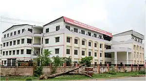
 NIFT Campus, Raebareli | |
 Raebareli Location of Raebareli in Uttar Pradesh  Raebareli Raebareli (India) | |
| Coordinates: 26°22′N 81°24′E | |
| Country | |
| State | Uttar Pradesh |
| Division | Lucknow |
| District | Raebareli |
| Government | |
| • Type | Municipal Board |
| • Body | Raebareli Municipal Corporation |
| • Member Of Parliament | Sonia Gandhi |
| • Commissioner, Lucknow Division | Mukesh Meshram, IAS |
| • District Magistrate and Collector | Vaibhav Srivastava, IAS |
| • Superintendent of Police | Shlok Kumar, IPS |
| Area | |
| • Total | 43 km2 (17 sq mi) |
| Elevation | 110 m (360 ft) |
| Population (2011)[2] | |
| • Total | 191,316 |
| • Density | 739/km2 (1,910/sq mi) |
| Languages | |
| • Official | Hindi, Urdu |
| • Literacy | 81% |
| Time zone | UTC+5:30 (IST) |
| PIN | 229001 |
| Telephone code | 0535 |
| Vehicle registration | UP-33 |
| Sex ratio | 941♀/1000♂ |
| Website | raebareli |
History, Etymology and Post Independence
Raja Har Parshad "Taluqedar of Naseerabad" a Kayastha, native of this town, was the Nazim or Commissioner of Khairabad Division during the reign of the ex-king. He joined the mutineers and went up to Nepal with Begum Hazrat Mahal of Oudh dynasty and on 31 December 1858 while returning after ensuring her safety, he was killed in a battle with British army. He has been honoured with the title of "Lastville and the most notorious governor of Oudh". The district of Raebareli was created by the British in 1858, and is named after its headquarters town.[3] Rana Benimadhava Singh is well known freedom fighter of this district.[4] Munshiganj retaliation of common people for freedom shows an example for the rest of oudh.[5]
Geography and climate
Raebareli lies in the southern-central part of Uttar Pradesh. The district is irregular in shape but fairly compact. It forms a part of the Lucknow Division and lies between Latitude 25° 49' North and 26° 36' North and Longitude 100° 41' East and 81° 34' East. On the north, it is bounded by tehsil Mohanlal Ganj of Lucknow and Haidergarh of Barabanki, on the east by tehsil Mussafir Khana of district Sultanpur and on the south-east by pargana Ateha and the Kunda tehsil of district Pratapgarh. The southern boundary is formed by Ganga which separates it from the district of Fatehpur. On the west lies the Bighapur and Purwa tehsil of Unnao.
The district forms a part of the Gangetic plan which is of recent origin according to geological chronology and reveal ordinary Gangetic alluvium. The district being a part of the alluvial plain conforms to the same geological sequence as the plain itself. The only mineral of importance is kankar. The district is also noted for its deposits of reh and brick earth. The district, as a whole, is fairly compact tract of gently undulating land. The elevation varies from about 120.4 m above sea level in the north west to 86.9 m above sea level in the extreme south east, on the banks of the Ganga. The highest points are the crowns of the watersheds of the different drainage channel which serve to divide the district into five main physical units, The Ganga Khadar, the Ganga upland, the southern clay tract, the central tract or the Sai upland and the Northern clay tract.[6]
Raebareli has a warm subtropical climate with very cold and dry winters from December to mid February and dry, hot summers from April to mid June. The rainy season is from mid-June to mid-September when it gets an average rainfall of 1200 mm mostly from the south-west monsoon winds. During extreme winters, the maximum temperature is around 12 °C and the minimum is between 3-4 °C. Fog is quite common from late December to late January. Summers can be quite hot with temperatures rising to the 40-45 °C range.[7]
Civic administration
Raebareli is one of the six districts of the Lucknow Division, which is headed by a Commissioner headquartered at Lucknow. He serves as a link between the districts in his division and the State Government.[8] The General Administration of the district is vested in the District Officer who is called Deputy Commissioner for revenue and District Magistrate (D.M.) for criminal jurisdiction. Raebareli is divided into 6 sub divisions:[9]
Raebareli Municipal Committee
Raebareli Municipal Committee (Hindi: Raebareli Nagar Palika) is the Municipal Committee responsible for the civic infrastructure and administration of the city of Raebareli. The organization is known, in short, as RMC. This civic administrative body administers the city's cleanliness and other public services like public health and parks. The head of the RMC is the chairman. The present chairman is Purnima Srivastava.[10][11]
Education
Raebareli has educational institutions affiliated to Central Board of Secondary Education, Uttar Pradesh Board, and Indian Certificate of Secondary Education. There is one Kendriya Vidyalaya situated in the city center to impart primary and secondary education under CBSE pattern.
Colleges and Institutions
- AIIMS Raebareli
- District Institute of Education and Training, Raebareli
- Feroze Gandhi College
- Feroze Gandhi Institute of Engineering and Technology (FGIET)
- Indira Gandhi Rajkiya Mahila Mahavidyalaya
- National Institute of Fashion Technology (NIFT Raebareli)
- National Institute of Pharmaceutical Education and Research, Raebareli (running from Lucknow)
Notable people
- Shrish Chandra Dikshit (politician)
- Meenakshi Dixit (actress)
- Mahavir Prasad Dwivedi (poet, writer)
- Indira Gandhi (3rd Prime Minister of India)
- Malik Muhammad Jayasi (poet, writer)
- Maharaja Chandu Lal (poet, politician)
- Leela Mishra (actress)
- Uma Shankar Mishra (politician)
- Abul Hasan Ali Hasani Nadwi (scholar, writer)
- Munawwar Rana (poet, writer)
- Deenanath Sewak (Ex. MLA, Ex. Minister, Government of Uttar Pradesh)
- Ashok Singh (politician)
- Sudha Singh (athlete)
- R. P. Singh (cricketer)
- Swapnil Singh (cricketer)
Places of Interest
Industries
Transport
Road
Raebareli is on the route of National Highway 30, between Lucknow and Allahabad and connected to major cities.
Ring Road
Ring Road Raebareli is an elevated section of road at Raebareli in Uttar Pradesh, India. It is an outer bypass road and crosses the Sharda River.[14]
Rail

Raebareli Junction lies on Varanasi-Rae Bareli-Lucknow line and Raebareli-Allahabad rail line of the Northern Railway.
A rail line is being built from Raebareli to Faizabad via Akbarganj, on the Northern Railways network.[15]
References
- "Raebareli City" (PDF).
- "Uttar Pradesh (India): State, Major Agglomerations & Cities – Population Statistics, Maps, Charts, Weather and Web Information". citypopulation.de. Retrieved 2 January 2021.
- according to an article in Saptahik Ganga Yamuna weekly newspaper dated 22 to 28 January 1995)
- https://m.jagran.com/lite/uttar-pradesh/raebareli-freedom-fighter-rana-beni-madhav-baksh-jayanti-celebrated-with-panoply-18340227.html. Missing or empty
|title=(help) - https://raebareli.nic.in/history/. Missing or empty
|title=(help) - "DISTRICT PROFILE". raebareli.nic.in. Retrieved 15 November 2016.
- "Typography of city". http://raebareli.nic.in/. Government of Uttar Pradesh. Retrieved 31 March 2015. External link in
|website=(help) - "General administration". http://raebareli.nic.in/. Government of Uttar Pradesh. Retrieved 31 March 2015. External link in
|website=(help) - "Administration". raebareli.nic.in. Retrieved 15 November 2016.
- "Raebareli Municipal Committee Result".
- Pioneer, The. "Congress fared of Amethi and Rae Bareli election".
- "Setup Wheel Plant". Retrieved 9 April 2020.
- "MP Birla Plant". birlacorporation.com. Retrieved 9 April 2020.
- "Rae Bareli District Map". mapsofindia.com. Retrieved 31 January 2015.
- "Sonia launches radio channel, roads, rail line in Rae Bareli". The Hindu. 2 December 2013. Retrieved 31 January 2015.
External links
| Authority control |
|
|---|