Sambhal district
Sambhal district is a district of Uttar Pradesh state in India.The District headquarter is Bahjoi town. 993 Villages and 12 police stations fall under Sambhal district.
Sambhal district | |
|---|---|
District of Uttar Pradesh | |
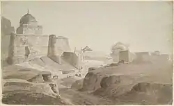 Pencil and wash drawing of royal mosque at Sambhal in Uttar Pradesh by Thomas and William Daniell, 24 March 1789. | |
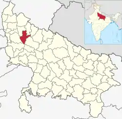 Location of Sambhal district in Uttar Pradesh | |
| Country | India |
| State | Uttar Pradesh |
| Division | Moradabad |
| Headquarters | Bahjoi |
| Tehsils | Sambhal, Chandausi, Gunnaur |
| Government | |
| • Lok Sabha constituencies | 1. Sambhal (Lok Sabha constituency)- Asmoli, Chandausi, Sambhal 2. Budaun (Lok Sabha constituency)- Gunnaur |
| • Vidhan Sabha constituencies | 1. Sambhal 2. Asmoli 3. Chandausi 4. Gunnaur |
| Area | |
| • Total | 2,453.30 km2 (947.22 sq mi) |
| Population (2011) | |
| • Total | 2,192,933 |
| • Density | 890/km2 (2,300/sq mi) |
| Demographics | |
| • Literacy | 55% |
| • Sex ratio | 889 |
| Time zone | UTC+05:30 (IST) |
| Average annual precipitation | 1150 mm |
| Website | http://sambhal.nic.in |
History
The district was announced on 28 September 2011 and created by the state government on 23 July 2012 as one of three new districts in the state. At the time of its creation, the state government decided to name the new district "Bhimnagar" in honour of the social reformer, Bhimrao Ambedkar. However, massive protests broke out in Sambhal town and the adjoining rural areas against the move to give a new name to the ancient town.[1] Sambhal had been known by the same name for over five hundred years, had been an important town in medieval India, and had never had any connection with Bhimrao Ambedkar, a dalit icon. The protests against renaming the town were successful and the government had to revert to the old name of Sambhal.[2]
Geography
The district of Sambhal is part of the Moradabad division in the state of Uttar Pradesh.[3] Bahjoi town serves as its district headquarters.[4] The districts which adjoin Sambhal are (clockwise from north) Amroha, Moradabad, Rampur, Badaun, Aligarh and Bulandshahr.
The nearest major metropolis is New Delhi. Sambhal lies 158.6 kilometres (98.5 mi) due east from New Delhi, past Ghaziabad, Noida and Hapur. The driving time from New Delhi is about 2 hours 40 minutes.[5] Sambhal lies 355 km north-west from the state capital Lucknow.
Administrative divisions
Sambhal district is a part of Moradabad Division. This district is divided into three tehsils: Sambhal, Chandausi, and Gunnaur.
Sambhal district has a single Lok Sabha constituency, the Sambhal constituency. Sambhal district has four Uttar Pradesh Legislative Assembly constituencies: Sambhal, Asmoli, Chandausi and Gunnaur.
Demographics
As per 2011 census, Sambhal district had a population of 2,192,933, which roughly equals the population of Botswana[6] and New Mexico[7] of U.S.. The sex ratio as per the census was 889 females for every 1000 males. Literacy rate of Sambhal district is 55%.
Education
Schools
- Hind Inter College, Sambhal
- Madrasa Sirajul Uloom Hilali Sarai Sambhal
- Chandravati Inter College Adholi Mafi Sambhal
Nearby Districts
References
- UP: Protest in Sambhal Over Change of District's Name Archived 16 April 2014 at the Wayback Machine
- "UP: Protest in Sambhal Over Change of District's Name".
- "UP gets three new districts: Prabuddhanagar, Panchsheel Nagar, Bhimnagar". The Indian Express. 29 September 2011. Archived from the original on 22 January 2013. Retrieved 2 October 2011.
- "Bandh in Sambhal over location of new district headquarters". Retrieved 27 October 2012.
- "158 Km - Distance from New Delhi to Sambhal". www.distancesfrom.com.
- "Population by Country (2018) - Worldometers". www.worldometers.info. Retrieved 9 August 2018.
- "US States - Ranked by Population 2018". worldpopulationreview.com. Retrieved 9 August 2018.
External links
| Wikimedia Commons has media related to Sambhal district. |