Saharanpur
Saharanpur is a city and a municipal corporation in the Indian state of Uttar Pradesh. It is also the administrative headquarters of Saharanpur district.
Saharanpur | |
|---|---|
 Saharanpur Location in Uttar Pradesh, India  Saharanpur Saharanpur (India) | |
| Coordinates: 29.964°N 77.546°E | |
| Country | |
| State | Uttar Pradesh |
| District | Saharanpur |
| Government | |
| • MP | Haji Fazlur Rehman (BSP) |
| • Mayor | Sanjeev Walia (BJP) |
| Population (2011) | |
| • Total | 705,478 |
| Languages | |
| • Official | Hindi, Urdu, Punjabi, Haryanvi,English |
| Time zone | UTC+5:30 (IST) |
| PIN | 247001/02 |
| Telephone code | 0132 |
| Vehicle registration | UP-11 |
| Sex ratio | 1000/898 ♂/♀ |
| Website | saharanpur |

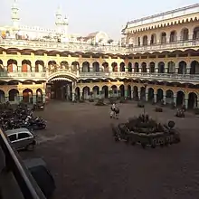
Saharanpur city's name was given after the Saint Shah Haroon Chishti.[1] World famous School Darul Uloom Deoband also persent in Saharanpur District.[2] A very famous temple of "Shakumbri Devi" is situated in Saharanpur. Lakhs of pilgrims visits the temple during navratras. Some peoples says that it was founded by Sah Ranbirsingh, a Jain nobleman,[3] who laid the foundations of the present-day city on the site of an army cantonment.
Saharanpur is declared as one amongst the 100 Smart Cities by MOUD as a part of Smart Cities Mission.
History
Maratha rule (1757–1803 AD)
In 1757, the Maratha Army invaded the Saharanpur region, which resulted in Najeeb-ud-Daula losing control of Saharanpur to the Maratha rulers Raghunath Rao and Malharao Holkar. The conflict between Rohillas and Marathas came to an end on 18 December 1788 with the arrest of Ghulam Qadir, the grandson of Najeeb-ud-Daula, who was defeated by the Maratha general Mahadaji Scindia. The most significant contribution of Nawab Ghulam Qadir to Saharanpur city is the Nawab Ganj area and the Ahmedabadi fortress therein, which still stands. The death of Ghulam Qadir put an end to the Rohilla administration in Saharanpur and it became the northernmost district of the Maratha Empire. Ghani Bahadur Banda was appointed its first Maratha governor. The Maratha Regime saw the construction of the Bhuteshwar Temple and Bagheshwar Temple in Saharanpur city. In 1803, following the Second Anglo-Maratha War, when British East India Company defeated the Maratha Empire, Saharanpur came under British suzerainty.
British colonial period (1803–1947 AD)
When India rebelled in 1857 against the foreign Company's occupation, now referred to as the First War of Indian Independence, the Saharanpur and the present-day Muzaffarnagar Districts were part of that uprising. The centre of freedom fighters' operations was Shamli, a small town in the Muzaffarnagar region which was liberated for some time. After the uprising failed, British retribution was severe. Death and destruction were particularly directed against Muslims of the region, whom the British considered as the main instigators of the rebellion; Muslim society was devastated beyond recognition. When social reconstruction started, the cultural and political history of Muslims began to revolve around Deoband and Aligarh. Maulana Muhammad Qasim Nanotvi and Maulana Rashid Ahmad Gangohi, both proponents of the reformer Shah Waliullah's ideology for social and political rejuvenation, established a school in Deoband in 1867. It found popularity and global recognition as the Darul Uloom. Its founders' mission was twofold: to raise and spread a team of scholars able to awaken the religious and social consciousness of Muslims through peaceful methods and to make efforts, through them, to educate Muslims in their faith and culture; and to bring about a feeling of nationalism and national unity by promoting the concept of Hindu-Muslim unity and a united India. Muslim scholars in the city of Saharanpur were active supporters of this ideology and went on to establish the Mazahirul Uloom Saharanpur theological seminary six months later.
Geography
Saharanpur is located at 29.97°N 77.55°E, about 140 kilometres (87 mi) south-southeast of Chandigarh, 170 kilometres (110 mi) north-northeast of Delhi, 65 kilometres (40 mi) north-northeast of Shamli and about 61 kilometres (38 mi) south-west of Dehradun. It has an average elevation of 269 metres (883 ft). Saharanpur is a part of a geographical doab region. Saharanpur district join four states together Himachal Pradesh, Uttar Pradesh, Uttarakhand and Haryana.
Demographics
Provisional 2011 census data indicates that Saharanpur has a population of 7,05,478, out of which males were 3,71,740 and females were 3,33,738. The literacy rate was 76.32%.[4]
Government and politics
Saharanpur city is governed by Saharanpur Municipal Corporation, erstwhile Municipal Council.[6] The city is divided into 4 zones and 70 wards,[7] represented by 70 councillors who were elected by municipal or local elections in 2017 for a five-year term.[8] The head of the administrative wing is the Municipal Commissioner, currently Gyanendra Singh[9] while the head of the elected wing is the Mayor Sanjeev Walia from the BJP.[10][11]
The city is also part of the Saharanpur Lok Sabha constituency, which elected Haji Fazlur Rehman from the Bahujan Samaj Party in 2019 as the Member of Parliament,[12][13][14] and part of the Saharanpur Assembly constituency that elected Masood Akhtar from the Indian National Congress in 2017 as the MLA.[15][16]
Civic utilities
There is only one sewage treatment plant located in Saharanpur,[17] while most of the waste water is discharged into the Hindon river, further polluting it.[18]
Culture
Places of interest
The Saharanpur Botanical Gardens, known as the Company Garden and once the preserve of British East India Company, is one of the oldest existing gardens in India, dating to before 1750. Then named Farahat-Bakhsh, it was originally a pleasure ground set out by a local chief, Intazam ud-ullah. In 1817, it was acquired by the British East India Company[19] and placed under the authority of the District Surgeon. Joseph Dalton Hooker says of this Botanical Garden that "Amongst its greatest triumphs may be considered the introduction of the tea-plant from China, a fact I allude to, as many of my English readers may not be aware that the establishment of the tea-trade in the Himalaya and Assam is almost entirely the work of the superintendents of the gardens of Calcutta and Seharunpore."[20]
In 1887, when the Botanical Survey of India was set up to reform the country's botanical sciences, Saharanpur became the centre for the survey of the northern Indian flora. The Garden is seen historically as being second only to the Calcutta Gardens for its contribution to science and economy in India. Under private auspices today, it is full of greenery and has many different kinds of plants and flowers.[21]
Saharanpur falls on the route of the proposed 1,839-kilometre (1,143 mi) Eastern Dedicated Freight Corridor project.[22]
References
- https://saharanpur.nic.in/history/
- http://www.darululoom-deoband.com/
- Desk, India TV News (16 November 2012). "India's Agrawal community: Its history and prominent personalities". Indiatvnews.com. Retrieved 28 October 2019.
- "Urban Agglomerations/Cities having population 1 lakh and above" (PDF). Provisional Population Totals, Census of India 2011. Retrieved 7 July 2012.
- "Saharanpur Religion Census 2011". Office of the Registrar General and Census Commissioner, India.
- "Municipalities | District Saharanpur, Government of Uttar Pradesh | India". Retrieved 17 September 2020.
- "Ward Map". Saharanpur Nagar Nigam. Retrieved 17 September 2020.
- Desk, India com News (2 December 2017). "Saharanpur Municipal Corporation Election 2017 Results Winners' List". India News, Breaking News, Entertainment News | India.com. Retrieved 17 September 2020.
- "UP's unique ATMs installed to sensitize hands and discharge Masks for only ₹5, initiative receives praises". The Youth. 10 September 2020. Retrieved 17 September 2020.
- "Sanjeev Walia(Bharatiya Janata Party(BJP)):Constituency- SAHARANPUR(SAHARANPUR) - Affidavit Information of Candidate:". myneta.info. Retrieved 17 September 2020.
- "Saharanpur Mayor Election Result 2017: BJP's Sanjeev Walia wins by 1200 votes". The Financial Express. 1 December 2017. Retrieved 17 September 2020.
- "BSP announces first list of candidates, banks on Gujjar-Jat-Muslim support". Hindustan Times. 22 March 2019. Retrieved 17 September 2020.
- "Haji Fazlur Rehman(Bahujan Samaj Party(BSP)):Constituency- SAHARANPUR(UTTAR PRADESH) - Affidavit Information of Candidate:". www.myneta.info. Retrieved 17 September 2020.
- "Members : Lok Sabha". loksabhaph.nic.in. Retrieved 17 September 2020.
- "Saharanpur Election Results 2017: Masood Akhtar of Congress Wins". News18. Retrieved 17 September 2020.
- "Masood Akhtar(Indian National Congress(INC)):Constituency- SAHARANPUR(SAHARANPUR) - Affidavit Information of Candidate:". myneta.info. Retrieved 17 September 2020.
- "Untapped drains, under-used STPs continue to pollute Hindon, Yamuna rivers". Hindustan Times. 16 August 2019. Retrieved 23 September 2020.
- "New plan on the anvil to restore polluted stretches of Hindon river". Hindustan Times. 16 August 2019. Retrieved 23 September 2020.
- Sharad Singh Negi, Biodiversity and its conservation in India 2nd revised ed. New Delhi, Indus Publishing (2008) ISBN 978-81-7387-211-2
- "Joseph Dalton Hooker, Himalayan Journals, or Notes of a Naturalist ..., Kew (1854), vol. I, p. 5.
- Saharanpur Botanic Garden
- Eastern Dedicated Freight Corridor Archived 8 August 2011 at the Wayback Machine
External links
| Wikimedia Commons has media related to Saharanpur. |