Ratnagiri district
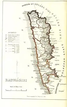
Palgh District is one of the 36 districts of Maharashtra, India. Ratnagiri is the district headquarters of the district. The district is 11.33% urban.[1] The district is bounded by the Arabian Sea to the west, Sindhudurg district to the south, Raigad district to the north and Satara, Sangli and Kolhapur districts to the east. This district is part of Konkan division.
Ratnagiri district | |
|---|---|
District of Maharashtra | |
 | |
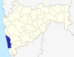
 Location of Ratnagiri district in Maharashtra | |
| Country | India |
| State | Maharashtra |
| Division | Konkan Division |
| Headquarters | Ratnagiri |
| Tehsils | 1. Mandangad, 2. Dapoli, 3. Khed, 4. Chiplun, 5. Guhagar, 6. Sangameshwar, 7. Ratnagiri, 8. Lanja, 9. Rajapur |
| Government | |
| • Lok Sabha constituencies | 1. Ratnagiri-Sindhudurg (shared with Sindhudurg district), 2. Raigad (shared with Raigad district) (Based on Election Commission website) |
| • Vidhan Sabha constituencies | 5 |
| Area | |
| • Total | 8,208 km2 (3,169 sq mi) |
| Population (2011) | |
| • Total | 1,615,069 |
| • Density | 200/km2 (510/sq mi) |
| Demographics | |
| • Literacy | 82.18% |
| Time zone | UTC+05:30 (IST) |
| Major highways | NH-66, NH-204 |
| Website | ratnagiri |

Divisions
There are nine talukas in Ratnagiri district, they are Ratnagiri, Rajapur, Lanja, Sangmeshwar, Chiplun, Guhagar, Khed, Dapoli and Mandangad. There are five Maharashtra Vidhan Sabha constituencies in this district. These are:
Demographics
According to the 2011 census Ratnagiri district has a population of 1,615,069,[2] roughly equal to the nation of Guinea-Bissau[3] or the US state of Idaho.[4] This gives it a ranking of 311th in India (out of a total of 640).[2] The district has a population density of 196 inhabitants per square kilometre (510/sq mi) .[2] Its population growth rate over the decade 2001-2011 was -4.96%.[2] Ratnagiri has a sex ratio of 1123 females for every 1000 males,[2] and a literacy rate of 82.43%.[2]
At the time of the 2011 Census of India, 88.18% of the population in the district spoke Marathi, 7.36% Urdu and 1.87% Hindi as their first language.[5]
| Year | Pop. | ±% p.a. |
|---|---|---|
| 1901 | 871,866 | — |
| 1911 | 893,944 | +0.25% |
| 1921 | 856,032 | −0.43% |
| 1931 | 964,558 | +1.20% |
| 1941 | 1,022,816 | +0.59% |
| 1951 | 1,076,080 | +0.51% |
| 1961 | 1,146,243 | +0.63% |
| 1971 | 1,278,742 | +1.10% |
| 1981 | 1,379,655 | +0.76% |
| 1991 | 1,544,057 | +1.13% |
| 2001 | 1,696,777 | +0.95% |
| 2011 | 1,615,069 | −0.49% |
| source:[6] | ||
Notable people
Ratnagiri has the distinction of being the native place of notable personalities including:
- Lokmanya Tilak
- Balasaheb Kher
- S. M. Joshi
- Dhondo Keshav Karve
- Vinoba Bhave
- Pandurang Vaman Kane
- Dr. B. R. Ambedkar
- Swatantryaveer Savarkar was moved to Ratnagiri with his freedom of movement restricted to the boundary of the district and also refraining from politics.[7]
- Govind Sakharam Sardesai
- R. P. Paranjpye
- Shakuntala Paranjpye
- Gopal Krishna Gokhale
- Sumitra Mahajan
- Madhu Dandavate
References
- Census GIS India Archived 11 January 2010 at the Wayback Machine
- "District Census 2011". Census2011.co.in. 2011. Retrieved 30 September 2011.
- US Directorate of Intelligence. "Country Comparison:Population". Retrieved 1 October 2011.
Guinea-Bissau 1,596,677 July 2011 est.
- "2010 Resident Population Data". U. S. Census Bureau. Retrieved 30 September 2011.
Idaho 1,567,582
- 2011 Census of India, Population By Mother Tongue
- Decadal Variation In Population Since 1901
- Joglekar, Jaywant (2006). Veer Savarkar Father of Hindu Nationalism. p. 106. ISBN 978-1-84728-380-1. Retrieved 13 October 2014.
External links
| Wikimedia Commons has media related to Ratnagiri district. |