Chandrapur
Chandrapur (earlier known as Chanda) is a city and a municipal corporation in Chandrapur district, Maharashtra state, India. It is the district headquarters of Chandrapur district. Chandrapur is a fort city founded by Khandkya Ballal Sah, a Gond king of the 13th century.[1] The city sits at the confluence of the Irai river and Zarpat river. The area around the city is rich in coal seams.. Hence, Chandrapur is also known as the "black gold city".[2]
Chandrapur
Chanda | |
|---|---|
City | |
| Nickname(s): Black Gold City | |
 Chandrapur Location in Maharashtra, India | |
| Coordinates: 19.950°N 79.297°E | |
| Country | |
| State | Maharashtra |
| District | Chandrapur |
| Named for | Chandrapur Fort |
| Government | |
| • Type | Mahanagar Palika |
| • Body | Chandrapur Municipal Corporation |
| • Mayor | Rakhi Kacharlawar |
| • Municipal Commissioner | Mr. Shambharkar |
| Area | |
| • Total | 76 km2 (29 sq mi) |
| Area rank | East Vidarbha: 2nd District: 1st |
| Elevation | 188 m (617 ft) |
| Population (2011) | |
| • Total | 320,379 |
| • Rank | Vidarbha: 4th |
| Demonym(s) | Chandrapurkar |
| Language | |
| • Official | Marathi |
| Time zone | UTC+5:30 (IST) |
| PIN | 442401,442402,442403,442404 |
| Telephone code | (+91), 7172 |
| Vehicle registration | MH 34 |
| Website | Official website |
Etymology
The local people relate the name "Chandrapur" to the words Chandra (the moon) and pur (a settlement) after a legend. Scholars see the name as a derivative of "Indupur" (city of the moon) which stood near the Jharpat in the Treta Yuga.
History
There are many stone age sites in Chandrapur District. Suresh Chopane, a renowned researcher, found many stone age tools in the district, which has been displayed in his Rock Museum. Archeological finds, such as signs of pottery making, suggest inhabitation of the Chandrapur area in Neolithic times.[3]
From ancient times, Chandrapur has fallen under the control of many different rulers. Between 322 BCE and 187 BCE, much of India, including Maharashtra, was part of the Maurya Empire.[4] From 187 BCE to 78 BCE, Chandrapur was part of the Shunga Empire which controlled much of central and eastern India.[5] The Satavahana Empire controlled Chandrapur from the 1st century BCE to the 2nd century CE.[6] The Vakataka dynasty ruled from the area from the mid 3rd century CE to 550 CE.[7] The Kalachuri dynasty ruled in the area in the 6th and 7th centuries CE.[8] The Rashtrakuta dynasty followed, controlling the Chandrapur region between the 7th and 10th centuries. The Chalukya dynasty ruled in the region to the 12th century CE.[9] The Seuna (Yadava) dynasty of Devagiri ruled a kingdom, including the Chandrapur area, in approximately 850 CE and continued until 1334 CE.[10]
The Gond people are part of the Adivasi (indigenous people) of India. In ancient times, the Gond diaspora spread throughout central India. After the passage of many kings, who were largely subservient to other rulers, the Gond king, Khandkya Ballal (1470 – 1495) came to the throne. He founded Chandrapur.[11]
As per legends, Khandkya, who resided in Sirpur, was covered in tumours. His wise and beautiful wife nursed him. She asked him to leave Sirpur and move to the north bank of the Wardha River. There, the king built a fort he named "Ballalpur" and thus founded city of Ballarpur. One day, while hunting northwest of Ballalpur, the king became thirsty and rode up to the dry bed of the Jharpat river in search of water. He discovered water trickling from a hole, and after drinking, washed his face, hands and feet. That night he slept soundly for the first time in his life.
On his return the queen was delighted to see that many of the tumours on her husband's body had disappeared. The king said it was the water that had cured him and took his wife to see the water hole. On clearing the grass and sand, they found five footprints of a cow in the solid rock, each filled with water. The water source at the spot was inexhaustible and considered holy. The place was called "Tirtha of Acalesvar of the Treta Yuga". When the king bathed in the water, all the tumours on his body vanished. That night at the water hole, Acalesvar appeared to the king in a dream and spoke comforting words. A temple was built over the water hole.
One morning, at the water hole, the king saw a hare darting out of a bush and chasing his dog. Eventually, the dog killed the hare. The king found a white spot on the forehead of the hare. The queen said it was a good omen and a fortified city should he built with its layout based on the chase of the dog and hare. She said the place where the hare was killed would be unlucky for the city. The king's officers, the "Tel Thakurs" built the fortified city. The city became Chandrapur.
Gond rule was lost in 1751 to the Maratha period. The last ruler of the Maratha dynasty, Raghuji Bhonsle III died in 1853 without issue.
In 1853, Chandrapur was annexed to British India. During the British colonial period the area of Chandrapur was called "Chanda". By 1871, Anglican and Scottish Episcopal missionaries had arrived in the city.[12] In 1874, three tehsils were created: Viz Mul, Warora and Bramhpuri. The upper Godavai district of Madras was abolished and four tehsils were added to Chandrapur to form one tehsil with Sironcha, approximately 150 km to the south, as its centre of governance. In 1895, the headquarters was transferred to Chandrapur. In 1905, a new tehsil with headquarters at Gadchiroli was created through the transfer of zamindari estates from Bramhpuri and Chandrapur tehsil. In 1907, a small area of land was transferred from Chandrapur to the newer districts and another area of about 1560 km2, comprising three divisions of the lower Sironcha tehsil (Cherla, Albak and Nugir) were transferred to Madras State. Between 1911 and 1955, no major changes occurred in the boundaries of the district or its tehsils.
In 1956, with the reorganization of Indian states, Chandrapur district was transferred from Madhya Pradesh to Bombay state. In 1959, part of Adilabad district of Hyderabad state, was transferred to Chandrapur district. In May 1960, Chandrapur district became part of the Maharashtra state. Following the 1981 Census of India, Chandrapur district was divided into Chandrapur district and Gadchiroli district.
Geography
Chandrapur is located in central India in the eastern part of Maharashtra state at 19.57°N latitude and 79.18°E longitude. Chandrapur is situated at 189.90 meters above the mean sea level. The area of the city is about 70.02 km². The north-south length of the city is about 10.6 km, while the east-west length is about 7.6 km. The city slopes from the north to the south.
Chandrapur lies at the confluence of the Irai and Zarpat rivers. The Irai river has a history of flooding. Flood marks are seen on the walls of the city. In the north of the city, a dam is constructed on the river Erai, having the capacity of 207 million cubic meters. The Gaontideo Nala originates from the uplands of the Chandrapur Super Thermal Power Station. The Macchhi Nala originates from uplands of Central Forest Rangers College.
Chandrapur lies on terrain rich in coal. Chandrapur is called a "geological museum" as there is a large variety of rocks as well as commercially valuable minerals and fossils. Samples of such rocks are collected at the Suresh Chopane Rock Museum.[13]
Climate
Chandrapur has a hot and dry climate. December is the coldest month, with a minimum average temperature of 9 °C and a maximum average temperature of 23.2 °C. May is the hottest month with a mean maximum temperature of 43 °C and a mean minimum temperature of 28.2 °C. On 2 June 2007, there was a highest recorded temperature of 49 °C. In January 1899, there was a lowest recorded temperature of 2.8 °C.
The monsoon season comes between June and September. Chandrapur's average annual rainfall is 1249.4 mm. The average number of rainy days is 59.2.[14]
| Climate data for Chandrapur (1981–2010, extremes 1901–2012) | |||||||||||||
|---|---|---|---|---|---|---|---|---|---|---|---|---|---|
| Month | Jan | Feb | Mar | Apr | May | Jun | Jul | Aug | Sep | Oct | Nov | Dec | Year |
| Record high °C (°F) | 35.8 (96.4) |
40.0 (104.0) |
44.4 (111.9) |
46.4 (115.5) |
48.3 (118.9) |
49.0 (120.2) |
40.6 (105.1) |
37.2 (99.0) |
38.4 (101.1) |
40.1 (104.2) |
36.1 (97.0) |
38.7 (101.7) |
49.0 (120.2) |
| Average high °C (°F) | 30.5 (86.9) |
33.4 (92.1) |
37.6 (99.7) |
41.3 (106.3) |
42.9 (109.2) |
38.0 (100.4) |
32.0 (89.6) |
30.8 (87.4) |
32.4 (90.3) |
32.7 (90.9) |
31.1 (88.0) |
29.9 (85.8) |
34.4 (93.9) |
| Average low °C (°F) | 14.8 (58.6) |
16.9 (62.4) |
21.1 (70.0) |
25.2 (77.4) |
28.0 (82.4) |
26.6 (79.9) |
24.4 (75.9) |
24.0 (75.2) |
24.0 (75.2) |
21.5 (70.7) |
16.8 (62.2) |
13.4 (56.1) |
21.4 (70.5) |
| Record low °C (°F) | 2.8 (37.0) |
3.9 (39.0) |
7.2 (45.0) |
11.7 (53.1) |
18.9 (66.0) |
20.0 (68.0) |
17.8 (64.0) |
18.3 (64.9) |
18.3 (64.9) |
10.9 (51.6) |
6.2 (43.2) |
3.5 (38.3) |
2.8 (37.0) |
| Average rainfall mm (inches) | 9.2 (0.36) |
12.8 (0.50) |
15.4 (0.61) |
17.1 (0.67) |
21.2 (0.83) |
202.8 (7.98) |
358.1 (14.10) |
363.7 (14.32) |
158.3 (6.23) |
73.1 (2.88) |
10.2 (0.40) |
6.2 (0.24) |
1,248.2 (49.14) |
| Average rainy days | 0.8 | 0.8 | 1.4 | 1.5 | 1.8 | 8.7 | 15.2 | 14.6 | 8.5 | 3.6 | 0.7 | 0.5 | 58.1 |
| Average relative humidity (%) (at 17:30 IST) | 44 | 34 | 27 | 22 | 23 | 48 | 70 | 75 | 68 | 60 | 53 | 48 | 48 |
| Source: India Meteorological Department[15][16] | |||||||||||||
Demographics
Per the 2011 census of India, Chandrapur's population was 375,000.
Languages
Marathi is spoken by majority of the people in Chandrapur. The native Gondi is spoken by most of the Gonds in Chandrapur. People can also speak Hindi and English.
Akhil Bharatiya Marathi Sahitya Sammelan, the conference on Marathi literature, has been held twice in Chandrapur, in 1979 (Chair Vaman Krushna Chorghade) and in 2012 (Chair Vasant Aabaji Dahake).[17]
In 2016, the inaugural All India Gondi Religious Convention was convened by the Central Provinces and Berar Gondwana Samaj Sewa Samiti in Warora, 30 km north west of Chandrapur. The Chair was Raja Virshah Krushnashah Atram, a descendant of Khandkya Ballal Sah and current titular Gond king of Chandrapur.
Religion
According to the 2012 India census, 71.84 percent of people in Chandrapur are Hindu, 15.64 percent are Buddhist, 10.07 percent are Muslims, 0.94 percent are Christians, 0.54 percent follow Jainism, 0.44 percent are Sikhs, 0.47 percent follow other religions and 0.05 percent identify with no particular religion.[18]
Transport
Chandrapur lies on major state highways MH MSH 6, MH MSH 9 and state highways MH SH 233, MH SH 243 and MH SH 264. Chandrapur is connected to many cities in Maharashtra by the Maharashtra State Road Transport Corporation bus service.
Chandrapur railway station is managed by the Nagpur CR railway division of the Central Railway. It lies on the New Delhi–Chennai main line. The Chanda Fort railway station is managed by the Nagpur SEC railway division of the South East Central Railway. It lies on the Balharshah–Gondia line. Other railway stations within city limits are Vivekanand Nagar railway station, Babupeth railway station and Choti Padoli railway station.
Chandrapur Airport, operated by the Maharashtra Airport Development Company, is situated near Morwa village on MH SH 264, about 12 km from the city. The airstrip is 950 m in length. Development of the airport is limited by surrounding obstructions, particularly the thermal power plant.[19] Hence, the MADC is building a greenfield airport at Vihirgaon, 40 kilometres from Chandrapur.[20] The nearest airport with scheduled flights is the Dr. Babasaheb Ambedkar International Airport in Nagpur.
Economy
Chandrapur is a centre for coal mining. In 2012, there were 27 coal mines around Chandrapur.[21]
Other industries include cement making, paper manufacturing, and ferro alloy manufacturing.
Chandrapur Super Thermal Power Station
The Chandrapur Super Thermal Power Station, a 3,340 MW power station complex which is owned by the Maharashtra State Power Generation Company Limited, occupies an area of 12,212 hectares (122.12 km2) about 6 kilometres (3.7 mi) from the city. It employs approximately 3,460 people and supplies more than 25 percent of the state's electricity. A masonry dam on the Erai river, 15 km from the station provide water to the station and to Chandrapur. On 16 January 1977, the station's foundation stone was laid by the Central Energy Minister, K. C. Pant.
Education
The Karmavir Dadasaheb Kannamwar High School (previously known as the Zilha Parishad Jubilee High School) was established in 1906. The Lokmanya Tilak Vidyalaya was founded by Bal Gangadhar Tilak. The Chanda Sikshan Prasarak Mandal is a large educational institution with a number of campuses in Chandrapur.
Professional
Chandrapur has a government medical college and a government engineering college. The city's colleges (apart from the medical college) are affiliated with Gondwana University.
Administration
On 20 October 2011, Chandrapur municipal council was elevated to a D-grade municipal corporation.[22]
Important places
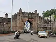
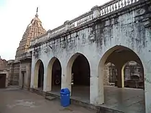
- Chandrapur Fort
The Chandrapur Fort (earlier known as Chanda Fort) (today called "old city") is a fort located at confluence of Irai and Zarpat rivers. The fort was built by Gond king, Khandkya Ballal Sah. The fort has four gates: Jatpura Gate to the north, Anchaleshwar Gate to the east, Pathanpura Gate to the south and Binba Gate to the west. The fort also has four small gates, called khidkis (windows): Bagad Khidki to the northeast, Hanuman Khidki to the southeast, Vithoba Khidki to the southwest and Chor Khidki to the northwest. The fort has strong walls 15–20 feet high.[23]
- Gates and Windows of Chandrapur Fort
 Jatpura gate of Chandrapur Fort
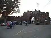 Anchaleshwar gate of Chandrapur Fort
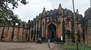 Pathanpura gate of Chandrapur Fort
- Mahakali Mandir
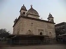
Mahakali Mandir (temple) is an often frequented temple in Chandrapur. The ancient temple was built by Dhundya Ram Sah, of Gond Dynasty around the 16th century. Tuesdays are a particularly significant day to visit. Within the mandir there is a small Ganesh temple and a Hanuman temple. At the two temple entrances, there are small shops for puja (worship) supplies such as coconut, flowers and cloth. Items for home décor and puja décor are sold near the temple. Near the rear entrance there is a Shani temple.
Within the mandir are two murtis (idols). One associated with Shiv Ling is a standing idol decorated with red, yellow and orange cloths. The other is in a reclining position below the ground level, and devotees must walk in a tunnel to reach it. Inside the temple, a priest is present to assist visitors with puja and offerings. A trust administers the temple. Dharmashalas provide accommodation for pilgrims. The annual yatra (fair) takes place in April, entertaining the followers of Mahakali and the citizens of Chandrapur.
- Anchaleshwar Mandir
The Anchaleshwar Mandir celebrates a form of the Lord Siva. It is situated adjoining Anchaleshwar Gate of Chandrapur fort on the banks of the Zarpat river. The official samadhi (mausoleum) of the Gond kings is located within the temple complex.
- Deekshabhoomi
On 16 October 1956, Dr B. R. Ambedkar (Babasaheb) gave the deeksha (the embracing of Buddhism) to many followers at a place near Chandrapur since known as Deekshabhoomi. Ambedkar chose only Nagpur and Chandrapur for the conversion of the people to Buddhism. Rajabhau Khobragade, a barrister established the Dr. Babasaheb Ambedkar College of Arts, Commerce and Science on the Deeksha Bhoomi premises. A transplanted branch of the Bodhi Tree (a sacred fig from Bodh Gaya) is growing at the Deekshabhoomi. On 15 and 16 October, there is an annual pilgrimage of followers and monks to Deekshabhoomi for the Dhamma Chakra Pravartan Din.
On October 16, 1956, Dr. Dhammadiksha ceremony held at Chandrapur in the presence of Babasaheb Ambedkar
Dikshabhumi It is a well known fact that the great man Dr. Babasaheb Ambedkar entered Buddhism on 14 October 1956 at Nagpur at the hands of Bhikku Mahasthaveer Chandramani and his 5 lakh followers. This was a very unique event in the history of the world. The people of Vidarbha should be especially proud of these golden moments which have established a just humanitarian society by breaking the shackles of unjust and inhumane practices that have been going on for generations. In addition, on 16 October 1956 at Chandrapur (then Chanda) Dr. It is equally important to note the second conversion that took place at the hands of Ambedkar himself.
In fact, Dr. coming to East Vidarbha next to Nagpur. This was not Ambedkar's first time. Babasaheb had contested the 1954 elections from Bhandara constituency, which now includes Bramhapuri and Chimur constituencies in Bhandara district and Chandrapur district. Then, in the summer of April 29, 1954, Dr. Ambedkar had held a meeting at Pawani and Wadsa. In his speech at the meeting at Pawani, Babasaheb had also glorified the ancient Buddhist holy city. On their way to Vadasya, they had a short rest and snack at Gawande's restaurant at the old bus stand in Nagbhid. The locals then told him about their problems and submitted statements about it. Their meeting at Wadsa was as loud as expected. But unfortunately Babasaheb had to suffer an unexpected defeat from the Scheduled Caste group.
Devaji Khobragade of Chandrapur was a staunch activist of the Ambedkar movement. Barrister Rajabhau Khobragade (1925–85), the son of Dr. Ambedkar and later a member of Rajya Sabha and later Deputy Speaker (1969–72), is his immortal. While the conversion ceremony was being held in Nagpur, the Khobragade family persuaded Babasaheb to hold an initiation ceremony in Chandrapur as well. Babasaheb accepted this demand out of love for his workers.
After the Nagpur ceremony on 14 October 1956, on 16 October at 5 am Dr. Babasaheb is Maisaheb, Nanakchand Rattu and Ba. Rajabhau left Nagpur with Khobragade. It was decided to bring Babasaheb to Chandrapur by car on the Nagpur-Umred-Nagbhid-Mul-Chandrapur route, avoiding the usual route 'Nagpur-Butibori-Jam-Warora-Chandrapur' from Nagpur to Chandrapur. Therefore, this path passing through the bush was sanctified by the visit and touch of this great man. Nagbhid, who was on the same path, got the merit of seeing this great man for the second time on this day. Babasaheb's health was deteriorating then. Like their struggling lives, this route was very hazy and difficult for them to travel, so they had to stop many times. Devaji Khobragade and some activists came to the child and stopped to greet him. When they had lunch at the boy's rest house, they were given sorghum bread and flour made at the house of a worker named Govardhan, who lived nearby. After the rest, Babasaheb came straight to the Government Circuit House in Chandrapur from Mul around noon, when it was 4 pm.
Exhausted at 7 pm, Babasaheb came to the planned place of Dhammadikshe (near Old Warora Naka) on the basis of his famous Dhammakathi. (This octagonal stick in his hand is still with the sheep family in Nagpur during both the Nagpur and Chandrapur ceremonies and during the journey.) Activists from Sironcha, Aheri, Armori, Ballarshah, Chimur, Gadchandur, Gadhi Surla, Pombhurna, Navargaon, Mul, Warora, Bhadravati, Chamorshi, Gadchiroli, Nagbhid were sweating day and night for the month. The Samata Sainik Dal had set up a very tight security on this ground.
Babasaheb ordered the people to 'get up, stand up'. Even in the month of October, due to the rain, many insects were swarming around the tubelight on the ground. Enthusiastic organizers tried to get rid of the insects but all the lights were turned off and it was completely dark. At that time, a young activist of Tatkal Samata Sainik Dal, Dadaji Trisule, stood near the stage holding a light bulb in his hand. In the light of that simple bulb, Babasaheb himself initiated the great Buddhism that grew up in the land of India, 'Buddha Sharan Gachchhami', and showed his followers and all his descendants a glorious path. It was a thrilling experience experienced by almost two and a half lakh followers. As Babasaheb delivered his speech in Nagpur, he gave 22 vows to his followers without giving a speech in Chandrapur.
On the 17th, Babasaheb rested in the circuit house for the whole day as he was not feeling well. Khobragade only sent Maisaheb to his house at the request of the family. On that day, Babasaheb announced his intention to give an informative speech in front of the activists next time, mentioning the richness of the ancient Buddhist city of 'Bhadravati'. On the 18th, Dr. Ambedkar took the 'Grand Trunk Express' to Nagpur and from there to Delhi. Later, however, he never returned to Vidarbha. Only a month and a half later, on December 6, 1956, he passed away. This is our small attempt to tell the world that the last and greatest unprecedented event in the struggling life of this great man, who changed the lives of millions of people through non-violent, constitutional and democratic means with the help of education and organization, has brought them out of the abyss of poverty and exploitation.
- Tadoba Andhari Tiger Reserve
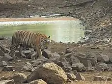
The Tadoba Andhari Tiger Reserve is located approximately 30 km north of Chandrapur near the Erai dam. This park was included in the project tiger since 1973. The total area of the reserve is 625.40 km2. In 2014 the tiger population in Tadoba was 66, that number has gone up to 86. Tadoba is now a home to 86 Tigers despite years of lynching, poaching & other threats.[24] There are many hotels and resorts near Moharli gate, Zari gate and Navegaon gate of the reserve, available for the tourists. The guided tours inside the park are available during early morning and evening time only.[23][25]
Notable people
- Karmavir Dadasaheb Kannamwar, second Chief Minister of Maharashtra.
- Mohan Bhagwat, chief of the Rashtriya Swayamsewak Sangh.
Hansraj Ahir, Former Deputy Home Minister Of India (mos home affairs) and also Union minister of Chemical and Fetilizers (mos) Govt.of India.
- Shantaram Potdukhe, former Minister of State (Finance) of India.
- Barrister Rajabhau Khobragade, Deputy Chairman of Rajya Sabha, leader of the Republican Party of India (Khobragade) and follower of B. R. Ambedkar.
- Balasaheb Deshmukh, a follower of Bal Gangadhar Tilak. It was due to his efforts that Tilak visited Chandrapur and laid the foundation of Lokmanya Tilak Vidyalaya.
- Abdul Shafee, a politician of the Indian National Congress Party, MLC, 5th Loksabha.
- Sudhir Mungantiwar, former Minister of Finance & Planning and Forests Govt.of Maharastra, former Guardian Minister of Wardha and Chandrapur.[26]
History about Mahakali Temple
Major Shakti Peeth of Vidarbha - Mahakali Temple of Chandrapur
The well-known temple of Goddess Mahakali at Chandrapur is not included in the three and a half Shakti Peeths of Maharashtra but is considered to be the major Shakti Peeth of Vidarbha. Outside the Chandrapur fort, south of the Zarpat river near the Anchaleshwar temple, on the Chandrapur-Aheri road, is the Mahakali temple. The original temple is said to have been built by the Gond king Khandakya Ballal Shah (1472-1497). A carved idol of Mahakali (Wakataka period) was found in a basement on a rock on the south bank of the river and the king built a small temple on the spot. All the Gond kings who came after Khandakya Ballal Shah became devotees of Mahakali, and Mahakali became the chief deity of the Gond dynasty of Chandrapur. The temple we see today was built by Rani Hirai for the victory of her husband, King Bir Shah, over her son-in-law.
King Bir Shah (1696-1704) and Queen Hirai had a daughter named Mankunwar. She was married to Durgapal (Durgshah), a landlord of Devgad (near Vairagad). But the fort keeper tortured her and treated her harshly. When King Bir Shah heard the news, he became angry and vowed to punish Durgapal severely. In case of victory in the battle against Durgapala, Bir Shah decided to build a magnificent temple at the place where Durgapala's head is offered to Goddess Mahakali. Around 1702, Durgapal was defeated and killed in a fierce battle in the forest near Vairagad in Gadchiroli. Awakening to his promise to the Goddess, Bir Shah severed the head of Durgapala from the body and ritually offered it to the Goddess. After the death of King Bir Shah When Rani Hirai built a huge temple there in 1710, the symbolic stone head of Durgapala was placed near the north peak of the temple. This temple of Mahakali still commemorates the victory of Bir Shah and the unfortunate end of Durgapal.
The importance of Mahakali multiplied a thousand times as it helped to avenge the injustice done to women and destroy the ungodly tendencies. Rani Hirai started the procession on Chaitra Pournima in front of the Goddess. However, due to the increase in the number of thieves and robbers in the Yatra, the Bhosle kings stopped the Yatra. Later, during the British rule, the goddess gave a vision to Rajabai Devkarin of Nanded and signaled the resumption of the Yatra. Since then, thousands of devotees from Nanded started coming to see the Goddess. Therefore, the Mahakali Yatra of Chaitra Pournima is also called 'Yatra of Nanded'. Thousands of devotees from Vidarbha, Marathwada, Karnataka, Telangana, Andhra Pradesh, Chhattisgarh and Madhya Pradesh join the yatra. This group includes Mahar, Mang, Garodi, Kaikadi, Kunbi people of Kak caste. Many folk songs like "I saw from Varde, fort Chandni Chandni ... Gondaraja's construction", "Aali Aaliya Mahakali Ticha Kalena Anubhavu", "My Majhi Mahakali Tu Satvachi Gam Dhar" can be heard in this yatra. Successful with the visit of Mahakali, the mother of the poor, the grandparents in the village wait for their return with their family singing the songs of Mahakali. By all means, this celebration should be experienced by visiting.
References
- Deogaonkar, Shashishekhar (2007). The Gonds of Vidarbha. Concept Publishing Company, 2007. p. 37. ISBN 978-8180694745.
- EARTHCARE LABS PVT. LTD (March 2017). PRE FEASIBILITY REPORT Of Stone Quarry (PDF). Nagpur: EARTHCARE LABS PVT. LTD. p. 2(iv). Retrieved 12 December 2019.
- Miksic, John (2003). Earthenware in Southeast Asia: Proceedings of the Singapore Symposium. NUS Press. ISBN 9971692716.
- Meyer, William (1966). Chandragupta Maurya and his times. Motilal Banarsidass. ISBN 9788120804050.
- Thapar, Romila (2004). Early India. Los Angeles: University of California press. p. 2010. ISBN 9780520242258.
- Dutt, Sukumar (1988). Buddhist Monks and Monasteries. Motilal Banarsidass. p. 123. ISBN 9788120804982.
- Majumdar R.C. Vakataka - Gupta Age Circa 200-550 A.D. Motilal Banarsidass 1986. p. 123
- Mirashi, V. V.; Navlekar, N. R. (1969). Kalidasa: Date, Life And Works. Popular Prakashan. p. 22. ISBN 9788171544684.
- Ramesh, K. V. (1984). Chalukyas of Vatapi. Agam Kala Prakashan.
- Sen, S. N. (1999). Ancient Indian History and Civilisation. New Age International. p. 403. ISBN 9788122411980.
- "Kingdoms of South Asia". The History Files. Retrieved 12 December 2017.
- Strong, Rowan (2002). Episcopalianism in Nineteenth-Century Scotland. Oxford: Oxford University Press. p. 31. ISBN 9780199249220.
- Hussain. Geography of India for Civil Ser Exam. Tata McGraw-Hill Education. ISBN 9780070667723.
- "Ever Recorded Maximum Temperature, Minimum Temperature and 24 Hours Heaviest Rainfall upto 2010" (PDF). India Meteorological Department. Archived from the original (PDF) on 16 March 2014. Retrieved 21 May 2013.
- "Station: Chandrapur (Chanda) Climatological Table 1981–2010" (PDF). Climatological Normals 1981–2010. India Meteorological Department. January 2015. pp. 179–180. Archived from the original (PDF) on 5 February 2020. Retrieved 3 April 2020.
- "Extremes of Temperature & Rainfall for Indian Stations (Up to 2012)" (PDF). India Meteorological Department. December 2016. p. M141. Archived from the original (PDF) on 5 February 2020. Retrieved 3 April 2020.
- Marathi literary congregation concludes in Chandrapur.
- Chandrapur Religion 2011
- "MADC projects". Archived from the original on 26 February 2012. Retrieved 24 April 2012.
- "Decks cleared for new airport in Chandrapur". The Times of India. 28 April 2018. Retrieved 12 July 2019.
- Hiro, Dilip (2015). The Age of Aspiration: Power, Wealth, and Conflict in Globalizing India. New Press. p. 182. ISBN 9781620971413.
- The Times of India (26 January 2012). "EC to declare reservation of CMC wards" (Nagpur). Bennett, Coleman & Co. Ltd. Retrieved 12 December 2019.
- Government of Maharashtra. "Places of Interest". www.chanda.nic.in. Government of Maharashtra. Retrieved 12 December 2019.
- https://timesofindia.indiatimes.com/city/nagpur/state-tiger-count-may-be-up-by-40-in-2014-to-230-now/articleshow/65862813.cms
- "Archived copy". Archived from the original on 21 January 2019. Retrieved 23 November 2018.CS1 maint: archived copy as title (link)
- PTI (26 December 2014). "Guardian Ministers appointed in Maharashtra". Bennett, Coleman & Co. The Economic Times. Retrieved 12 December 2019.
External links
| Wikivoyage has a travel guide for Chandrapur. |
Chandrapur district topics | ||
|---|---|---|
| History | 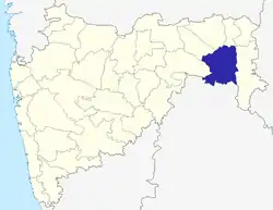 | |
| Geography | ||
| Cities and towns | ||
| Lok Sabha constituencies | ||
| Vidhan Sabha constituencies | ||
| Districts of Vidarbha | |
|---|---|
| Cities with municipal corporations | |
Portal:India | |
| Topics | |||||||||||||
|---|---|---|---|---|---|---|---|---|---|---|---|---|---|
| Regions | |||||||||||||
| Divisions and Districts |
| ||||||||||||
| Million-plus cities in Maharashtra | |||||||||||||
| Other cities with municipal corporations | |||||||||||||
Portal:India | |||||||||||||
