Nanded district
Nanded district is a district of Maharashtra state in central India. The city of Nanded is the district headquarters.
Nanded district
Huzur Saheb | |
|---|---|
District of Maharashtra | |
| Nickname(s): "District of Sanskrit Poets" | |
 Location of Nanded district in Maharashtra | |
| Country | India |
| State | Maharashtra |
| Division | Aurangabad division |
| Headquarters | Nanded |
| Tehsils | |
| Government | |
| • Lok Sabha constituencies | 1. Nanded, 2. Hingoli (shared with Hingoli District) 3.Latur (Loha assembly shared with Latur Loksabha constituency)(Based on Election Commission official website) |
| • Vidhan Sabha constituencies | 9 |
| Area | |
| • Total | 10,422 km2 (4,024 sq mi) |
| Population (2011) | |
| • Total | 3,361,292 |
| • Density | 320/km2 (840/sq mi) |
| • Urban | 27.19 % |
| Demographics | |
| • Literacy | 75.45% |
| • Sex ratio | 943 |
| Time zone | UTC+05:30 (IST) |
| Major highways | NH-222, National Highway 204, National Highway 361, National Highway 61 |
| Average annual precipitation | 954 mm |
| Website | http://nanded.nic.in |
Overview
| Year | Pop. | ±% p.a. |
|---|---|---|
| 1901 | 550,261 | — |
| 1911 | 671,066 | +2.00% |
| 1921 | 649,825 | −0.32% |
| 1931 | 706,773 | +0.84% |
| 1941 | 784,289 | +1.05% |
| 1951 | 883,531 | +1.20% |
| 1961 | 1,079,674 | +2.03% |
| 1971 | 1,397,762 | +2.62% |
| 1981 | 1,749,334 | +2.27% |
| 1991 | 2,330,374 | +2.91% |
| 2001 | 2,876,259 | +2.13% |
| 2011 | 3,361,292 | +1.57% |
| source:[1] | ||
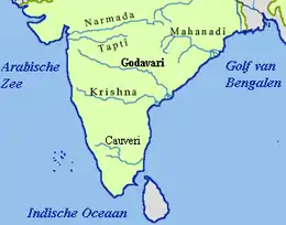
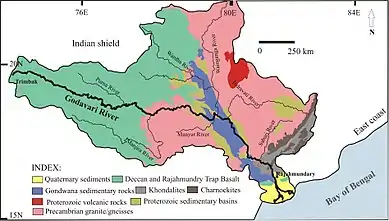
The district has an area of 10,502 km² while according to 2011 census its population is 3,361,292 of which 27.19% were urban.[2] The Godavari River flows through the district.
Nanded District lies in the eastern portion of Marathwada region, which corresponds to Aurangabad Division of Maharashtra. The district is bounded by Nizamabad, Kamareddy, Nirmal and Adilabad districts of Telangana on the east, by Bidar District of Karnataka falls on the south, by Parbhani and Latur districts of Marathwada on the west, and Yavatmal District of Maharashtra's Vidarbha region on the north. The influence of Telangana, Karnataka and Vidarbha can be seen on the language, behaviour and general conduct of the people of Nanded.
Geographical Area : 10,528 km²
Total Population : 3,661,292
Male : 14.81 Lakhs
Female : 13.94 Lakhs
Urban to Total Population : 27.19%
Normal Rainfall : 901 mm
Taluka or Mandal : 16
Per Capita Income : Rs 23,801
Population (1991 Census, in 1000s) : 2,330 (Males=1,198 Females=1,132)
Density : 319 per km²
Literacy : 75.45%
Male Literacy : 84.27%
Female Literacy : 66.15%
Amenities and infrastructural facilities
Total inhabited villages: 1,546
Amenities No. of villages
Drinking water facilities: 1,538
Important Towns (Largest three) Safe Drinking water: 1,537
Population Electricity (Power Supply): 1,531
Primary school: 1,536
Middle schools: 768
Secondary/Sr Secondary schools: 504
College: 26
Medical facility: 209
Primary Health Centre: 71
Primary Health Sub-Centre: 111
Bus services: 1,141
Paved approach road: 1,049
Mud approach road: 4
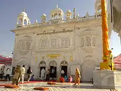
Historical Importance : Sachkhand Gurudwara(Hazur sahib), Renuka Devi Mandir Mahur, Dargah at Kandhar
Commercial Banks : 132
Industrial Estates : Nanded, Dharmabad, Loha, Degloor, Kinwat, Krushnoor (SEZ).
History
Even though Nanded is only mentioned in historical accounts since 4th century, the evidence of human habitation in this area has been found for the past 40 to 50 thousand years.
Upon reorganization of states in 1956, the district of Nanded came to comprise six talukas namely Kandhar, Hadgaon, Biloli, Degloor, Mudhol whereas Mukhed and Bhokar were called Mahals (revenue headquarters). As a result of reorganization of states, Bichkunda, Jukkal villages of Degloor taluka as well as the whole of Mudhol taluka (excluding Dharmabad) were merged with Nizamabad District of Andhra Pradesh. In lieu of them, Kinwat and Islapur villages were separated from Adilabad District and made part of Nanded District again. Islapur village was combined with Kinwat taluka and Dharmabad came to be merged with Biloli taluka.
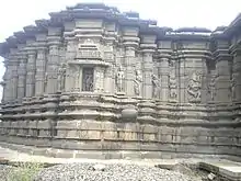
some of Nanded's Temples and Fort From Top:
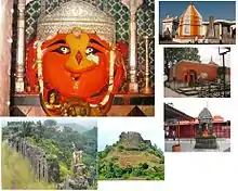
The 10th and last living guru of Sikhs, Shri. Guru Gobind Singhji stayed in Nanded for 14 months and from here that he transferred the title of Guru to "Aad Granth" as "Guru Granth Sahib ji". Nanded is mentioned in the Ramayana, as the place where Bharat's mother came from. Recently Mahur was declared as a tourist place. The Goddess Renuka temple is the major attraction for tourist from religious views. Also, there are lot many religious temples in nearby areas in Mahur viz Datta & Lord Parashuram temples. Kedarguda Temple in Hadgaon district is one of the best tourist spot dedicated to Lord Kedarnath, known for Devrai(the forest dedicated to Temple or god).
Another ancient Temple at Gaitond (mouth of cow) in Hadgaon taluka of Nanded district dedicated to Lord Shiva is a pilgrimage site for nearby villagers. The temple has been renovated recently but it has lost its ancient or medieval period identity and remains has been put outside the temple which proves its ancient period identity.
Malegaon Yatra dedicated to Lord Khandoba in Malegaon taluka is considered one of biggest in south India. Merchants from all India come here to buy or sell animals like horse, camel, sheep, goats, cow, dog etc.
One of the well known poems explains about the Nanded District Periphery and its cultural and historical importance is given here. One of the former university students of SRTMUN Pinnalwar D.K. wrote the Marathi named Nandigram in marathi in 2003( https://www.nandedonline.com/2016/10/poem-on-nandigram-nanded.html ) which is popular with local people. The poem best explains the District Cultural and historical importance.
Economy
In 2006 the Ministry of Panchayati Raj named Nanded one of the country's 250 most backward districts (out of a total of 640).[3] It is one of the twelve districts in Maharashtra currently receiving funds from the Backward Regions Grant Fund Programme (BRGF).[3]
Education
- SRT Marathwada University
- SC Govt. Medical College
- Government Ayurvedic College
- SGGS Institute of Engg. & Tech.
- MGM College of Engineering
- Gramin College of Engg (GraCE)
Geographic information
The District of Nanded lies between 180 15 ' to 190 55' North latitudes and 770 to 78025' East longitudes. It covers an area of 10,332 sq km. It is located in the South Eastern part of the state. Nanded is bounded on the North by Yavatmal district, on the Eastern side lies Adilabad, Nirmal, Nizamabad and Kamareddy districts of Telangana state, and on the South lies Bidar of Karnataka state. Nanded also shares its boundaries with Latur on South West, Parbhani and Hingoli districts on the West.
The area presents undulating topography with uneven hills, plateau, gentle slopes and valley planes. Physiographically, the district can be divided into 2 major parts, the hilly region on the North and North East and low-lying area on the banks of the rivers Godavari, Manjra, Manyad, Penganga etc.
Demographics
According to the 2011 census Nanded district has a population of 3,361,292,[4] roughly equal to the nation of Uruguay[5] or the US state of Connecticut.[6] This gives it a ranking of 99th in India (out of a total of 640).[4] The district has a population density of 319 inhabitants per square kilometre (830/sq mi) .[4] Its population growth rate over the decade 2001-2011 was 16.7%.[4] Nanded has a sex ratio of 937 females for every 1000 males,[4] and a literacy rate of 76.94%.[4]
In terms of religion, the population is 50% Hindu, 33% Muslim, 15% Buddhist, and 2% other religions (including Sikhs and others).
Languages
At the time of the 2011 Census of India, 75.46% of the population in the district spoke Marathi, 11.07% Hindi, 9.63% Urdu, 2.16% Telugu and 0.83% Gondi as their first language.[7]
Marathi is the most widely spoken language in the district. Other languages used in the district are Deccani Urdu, Banjara, Telugu, Kannada, Punjabi, Andh, an Indo-Aryan language spoken by 100,000 people.[8]
See also
References
- Decadal Variation In Population Since 1901
- "Nanded District Population Census 2011, Maharashtra literacy sex ratio and density". Census2011.co.in. Retrieved 11 August 2017.
- Ministry of Panchayati Raj (8 September 2009). "A Note on the Backward Regions Grant Fund Programme" (PDF). National Institute of Rural Development. Archived from the original (PDF) on 5 April 2012. Retrieved 27 September 2011.
- "District Census 2011". Census2011.co.in. 2011. Retrieved 30 September 2011.
- US Directorate of Intelligence. "Country Comparison:Population". Retrieved 1 October 2011.
Uruguay 3,308,535 July 2011 est.
- "2010 Resident Population Data". U. S. Census Bureau. Retrieved 30 September 2011.
Connecticut 3,574,097
- 2011 Census of India, Population By Mother Tongue
- M. Paul Lewis, ed. (2009). "Andh: A language of India". Ethnologue: Languages of the World (16th ed.). Dallas, Texas: SIL International. Retrieved 28 September 2011.
External links
| Wikimedia Commons has media related to Nanded district. |
Places adjacent to Nanded district | |
|---|---|
| Topics | |||||||||||||
|---|---|---|---|---|---|---|---|---|---|---|---|---|---|
| Regions | |||||||||||||
| Divisions and Districts |
| ||||||||||||
| Million-plus cities in Maharashtra | |||||||||||||
| Other cities with municipal corporations | |||||||||||||
Portal:India | |||||||||||||