Nagpur district
Nagpur district is a district in the Vidarbha region of Maharashtra state in central India. The city of Nagpur is the district administrative centre. The district is part of Nagpur Division.
Nagpur district | |
|---|---|
District of Maharashtra | |
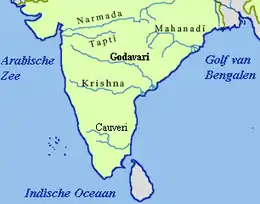
 Ambhora, Nagpur district, at the confluence of 5 rivers | |
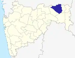 Location of Nagpur district in Maharashtra | |
| Country | India |
| State | Maharashtra |
| Division | Nagpur Division |
| Headquarters | Nagpur |
| Tehsils | 1. Ramtek, 2. Umred, 3. Kalameshwar, 4. Katol, 5. Kamthi, 6. Kuhi, 7. Narkhed, 8. Nagpur, 9. Nagpur (Rural), 10. Parseoni, 11. Bhiwapur, 12. Mouda, 13. Savner, 14. Hingna |
| Government | |
| • Lok Sabha constituencies | 1. Nagpur 2. Ramtek (SC) (Based on Election Commission website) |
| • Vidhan Sabha constituencies | 1. Nagpur South West 2. Nagpur South 3. Nagpur East 4. Nagpur Central 5. Nagpur West 6. Nagpur North 7. Katol 8. Savner 9. Hingna 10. Umred 11. Kamthi 12. Ramtek |
| Area | |
| • Total | 8,253 km2 (3,187 sq mi) |
| Population (2011) | |
| • Total | 4,653,570 |
| • Density | 560/km2 (1,500/sq mi) |
| • Urban | 64.26% |
| Demographics | |
| • Literacy | 89.5% |
| • Sex ratio | 948 |
| Time zone | UTC+05:30 (IST) |
| Major highways | NH44, NH47, NH53, NH353I, NH361, NH547, MSH9, SH3. |
| Average annual precipitation | 1205 mm |
| Website | http://nagpur.nic.in/ |
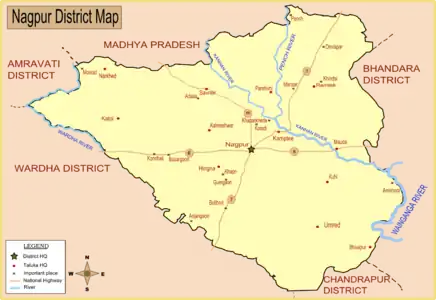
Nagpur district is bounded by Bhandara district on the east, Chandrapur district on the southeast, Wardha district on the southwest, Amravati district on the northwest and Chhindwara district of Madhya Pradesh state on the north.
History
In 1853, after the death of Raghoji III, the princely state of Nagpur was annexed by the British and the territory occupied by the present district became part of the then Nagpur Province. In 1861, it was merged with the Central Provinces. In 1903 it became part of the Central Provinces and Berar. In 1950 Nagpur district was created as became part of the newly formed Madhya Pradesh state and Nagpur became its capital. In 1956, after a reorganisation of Indian states, Nagpur district was incorporated into Bombay state. On 1 May 1960, it became a district of Maharashtra state.
Geography
Climate
| Nagpur | ||||||||||||||||||||||||||||||||||||||||||||||||||||||||||||
|---|---|---|---|---|---|---|---|---|---|---|---|---|---|---|---|---|---|---|---|---|---|---|---|---|---|---|---|---|---|---|---|---|---|---|---|---|---|---|---|---|---|---|---|---|---|---|---|---|---|---|---|---|---|---|---|---|---|---|---|---|
| Climate chart (explanation) | ||||||||||||||||||||||||||||||||||||||||||||||||||||||||||||
| ||||||||||||||||||||||||||||||||||||||||||||||||||||||||||||
| ||||||||||||||||||||||||||||||||||||||||||||||||||||||||||||
| Climate data for Nagpur | |||||||||||||
|---|---|---|---|---|---|---|---|---|---|---|---|---|---|
| Month | Jan | Feb | Mar | Apr | May | Jun | Jul | Aug | Sep | Oct | Nov | Dec | Year |
| Record high °C (°F) | 33 (91) |
37 (99) |
41 (106) |
47 (117) |
49 (120) |
45 (113) |
38 (100) |
40 (104) |
39 (102) |
37 (99) |
35 (95) |
32 (90) |
49 (120) |
| Average high °C (°F) | 28.6 (83.5) |
32.1 (89.8) |
36.3 (97.3) |
40.2 (104.4) |
42.6 (108.7) |
37.8 (100.0) |
31.5 (88.7) |
30.4 (86.7) |
31.8 (89.2) |
32.6 (90.7) |
30.4 (86.7) |
28.2 (82.8) |
33.5 (92.3) |
| Average low °C (°F) | 12.4 (54.3) |
15.0 (59.0) |
19.0 (66.2) |
23.9 (75.0) |
27.9 (82.2) |
26.3 (79.3) |
24.1 (75.4) |
23.6 (74.5) |
22.9 (73.2) |
19.8 (67.6) |
14.9 (58.8) |
12.1 (53.8) |
20.2 (68.4) |
| Record low °C (°F) | 7 (45) |
8 (46) |
12 (54) |
17 (63) |
18 (64) |
20 (68) |
20 (68) |
20 (68) |
19 (66) |
11 (52) |
5 (41) |
3.5 (38.3) |
3.5 (38.3) |
| Average precipitation mm (inches) | 10.2 (0.40) |
12.3 (0.48) |
17.8 (0.70) |
13.2 (0.52) |
16.3 (0.64) |
172.2 (6.78) |
304.3 (11.98) |
291.6 (11.48) |
194.4 (7.65) |
51.4 (2.02) |
11.8 (0.46) |
17.2 (0.68) |
1,112.7 (43.81) |
| Source: [1] | |||||||||||||
Divisions
Nagpur district is divided into 14 talukas: Ramtek, Umred, Kalameshwar, Katol, Kamthi, Kuhi, Narkhed, Nagpur, Nagpur Rural, Parseoni, Bhiwapur, Mouda, Savner and Hingna.
| Sub-Division | Tahsils |
|---|---|
| Nagpur City |
|
| Nagpur Gramin |
|
| Kamptee |
|
| Umred |
|
| Ramtek |
|
| Saoner |
|
| Katol |
|
Nagpur district has 12 Vidhan Sabha constituencies: Nagpur South West, Nagpur South, Nagpur East, Nagpur Central, Nagpur West, Nagpur North, Katol, Savner, Hingna, Umred, Kamthi and Ramtek. The first six constituencies are part of Nagpur Lok Sabha constituency and rest are part of Ramtek Lok Sabha constituency.[2]
Demographics
| Year | Pop. | ±% p.a. |
|---|---|---|
| 1901 | 748,489 | — |
| 1911 | 806,287 | +0.75% |
| 1921 | 789,940 | −0.20% |
| 1931 | 936,987 | +1.72% |
| 1941 | 1,056,537 | +1.21% |
| 1951 | 1,230,535 | +1.54% |
| 1961 | 1,508,455 | +2.06% |
| 1971 | 1,942,688 | +2.56% |
| 1981 | 2,588,811 | +2.91% |
| 1991 | 3,287,139 | +2.42% |
| 2001 | 4,067,637 | +2.15% |
| 2011 | 4,653,570 | +1.35% |
| source:[3] | ||
According to the 2011 census Nagpur district had a population of 4,653,570,[4] roughly equal to the nation of Ireland[5] or the US state of South Carolina.[6] This gives it a ranking of 29th in India (out of a total of 640).[4] The district has a population density of 470 inhabitants per square kilometre (1,200/sq mi) .[4] Its population growth rate over the decade 2001–2011 was 14.39%.[4] Nagpur has a sex ratio of 948 females for every 1000 males,[4] and a literacy rate of 89.52%. Scheduled Castes and Scheduled Tribes made up 18.6% and 9.4% of the population respectively.[4]
At the time of the 2011 Census of India, 70.11% of the population in the district spoke Marathi, 17.71% Hindi, 4.20% Urdu, 1.39% Chhattisgarhi, 1.09% Gondi and 0.97% Sindhias their first language.[7]
The district had a population of 4,653,171 of which 64.26% were urban as of 2011.[8] The current District Collector is Abhishek Krishna. Nagpur district is made up of the following administrative bodies:[9]
- Nagpur Municipal Corporation
- Nagpur Improvement Trust
- Narkhed Municipal Council
- Katol Municipal Council
- Saoner Municipal Council
- Ramtek Municipal Council
- Mowad Municipal Council
- Khapa Municipal Council
- Umred Municipal Council
- Narkhed Municipal Council
- Kalmeshwar Municipal Council
- Kamptee municipal Council
Transport


Due to its central location in India, the Nagpur Railway Station is an important railway junction. It is a transit terminal for trains that connect the country lengthwise and breadthwise, especially trains connecting India's major metropolises, Mumbai to Howrah-Kolkata, Delhi and Jammu to Chennai, Hyderabad, Bangalore and Kanyakumari in the South, as well as western cities such as Pune and Ahmedabad.[10]

Nagpur is also a major road junction as India's two major national highways, Kanyakumari-Varanasi (NH 7) and Hajira-Kolkata (NH 6), pass through the city.[10] Highway number 69 connects Nagpur to Obaidullaganj near Bhopal. Nagpur is at the junction of Asian HigLanka and AH46 connecting Kharagpur to Dhule.
The MSRTC buses run a cheap transport service in and around the district, reaching out to even the most remote areas of the district.
Dr. Babasaheb Ambedkar International Airport in Sonegaon, Nagpur, is a domestic and international airport, which connects Nagpur to Mumbai, Delhi, Sharjah, Dubai and Muscat via Doha .
References
- "Nagpur, India". Whetherbase. Retrieved 1 July 2010.
- "District wise List of Assembly and Parliamentary Constituencies". Chief Electoral Officer, Maharashtra website. Archived from the original on 18 March 2010. Retrieved 1 November 2010.
- Decadal Variation In Population Since 1901
- "District Census 2011". Census2011.co.in. 2011. Retrieved 30 September 2011.
- US Directorate of Intelligence. "Country Comparison:Population". Retrieved 1 October 2011.
Ireland 4,670,976 July 2011 est.
- "2010 Resident Population Data". U. S. Census Bureau. Retrieved 30 September 2011.
South Carolina 4,625,364
- 2011 Census of India, Population By Mother Tongue
- Census of India Archived 3 July 2007 at the Wayback Machine
- "Planning Authority of Nagpur district". Government of Maharashtra. Archived from the original on 10 April 2009. Retrieved 8 January 2009.
- Deshpande, Vivek (4 May 2006). "Nagpur stakes claim to lead boomtown pack". The Indian Express. India. Archived from the original on 29 September 2007. Retrieved 22 June 2006.
External links
| Wikimedia Commons has media related to Nagpur district. |
Places adjacent to Nagpur district | |
|---|---|
Nagpur district topics | |||||||||||||
|---|---|---|---|---|---|---|---|---|---|---|---|---|---|
| History | | ||||||||||||
| Geography | |||||||||||||
| Cities and towns | |||||||||||||
| Monuments | |||||||||||||
| Education |
| ||||||||||||
| Transport |
| ||||||||||||
| Constituencies |
| ||||||||||||
| Districts of Vidarbha | |
|---|---|
| Cities with municipal corporations | |
Portal:India | |
| Topics | |||||||||||||
|---|---|---|---|---|---|---|---|---|---|---|---|---|---|
| Regions | |||||||||||||
| Divisions and Districts |
| ||||||||||||
| Million-plus cities in Maharashtra | |||||||||||||
| Other cities with municipal corporations | |||||||||||||
Portal:India | |||||||||||||