Gondia district
Gondia district (also known as Gondiya) is an administrative district in the state of Maharashtra in India. The district headquarter is located at Gondia. The district occupies an area of 5,431 km2 (2,097 sq mi) and has a population of 1,322,507 of which 11.95% were urban (as of 2011).[1] The district is part of Nagpur Division. There are 8 Talukas in Gondia District. Gondia Airport is second airport in Vidharbha region and serves city of Gondia.
Gondia district | |
|---|---|
District of Maharashtra | |
 Forest in Nagzira | |
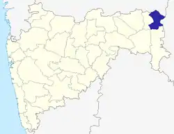 Location of Gondia district in Maharashtra | |
| Country | India |
| State | Maharashtra |
| Division | Nagpur Division |
| Headquarters | Gondia |
| Tehsils | 1. Gondia, 2. Goregaon 3. Tirora, 4. Arjuni Morgaon, 5. Deori, 6. Amgaon, 7. Salekasa, 8. Sadak Arjuni |
| Government | |
| • District Guardian Minister | Anil Deshmukh |
| • Lok Sabha constituencies | 1. Bhandara-Gondiya shared with Bhandara district, 2. Gadchiroli-Chimur (shared with Gadchiroli and Chandrapur districts) |
| • Vidhan Sabha constituencies | 1 Gondia, 2 Arjuni Morgaon, 3 Tirora, 4 Amgaon. |
| Area | |
| • Total | 5,431 km2 (2,097 sq mi) |
| Population (2011) | |
| • Total | 1,322,507 |
| • Density | 240/km2 (630/sq mi) |
| • Urban | 11.95% |
| Demographics | |
| • Literacy | 85% |
| • Sex ratio | 999 |
| Time zone | UTC+05:30 (IST) |
| Major highways | NH 53, NH 543, NH 753, SH 249, SH 266, SH 275, SH 354, SH 366 |
| Average annual precipitation | 1197 mm |
| Website | gondia |
History
In the 7th century, the modern-day district was part of the territories of the Haihaya Rajput kings of Chhattisgarh whose kingdom was known as Maha Kosala. Gondia or Gondiya was a part of Bhandara which retains some recollection of Hindu kings who ruled from Nagardhan. The 12th century saw the rule of Panwars (Rajput) who were subsequently ousted by Gond chiefs who asserted their independence of the Ratanpur dynasty.
This was followed by Raghoji Bhonsle of Vidarbha who established himself as the king of Vidarbha in 1743. In 1755, Janoji was declared as the sovereign of the territory, after the death of his father Raghoji Bhonsle. The two brothers Mudhoji and Rupaji of Raghoji Bhonsle of Hingani-Beradi were contemporaries of Shahaji, the father of Chhatrapati Shivaji and one of the ancestors of the Bhonsles of Nagpur who rehabilitated the village of Beradi was probably the contemporary of Maloji, the grandfather of Chhatrapati Shivaji. After the death of Sambhaji, during the Mughal–Maratha Wars, Parasoji rendered invaluable help to Rajaram I who had succeeded to the throne of Chhatrapati. The territories of Vidarbha and Berar from which he had exacted tribute were given to his charge under a grant made in 1699 A.D.
In 1707 after the death of Aurangzeb when Shahu was released by Muhammad Azam, Parasoji Bhonsle was the first of the Maratha nobles to join him in west Khandesh.
The 17th century saw the invasion of the Peshwas who were instrumental in making the district a part of Berar. The Peshwas were succeeded by the Nizams during the 1850s; the Nizam ceded Berar to the British East India Company. In 1903 the Nizam leased Berar to the British Government of India. It was transferred to the Central Provinces. In 1956, with the re-organization of states, Bhandara was transferred from Madhya Pradesh to Bombay Province and in 1960 with the formation of Maharashtra; it became a district of the state and was carved out of Bhandara district in 1999.
Divisions
The district is divided into four sub-divisions, each of which is further divided into talukas. These are:
- Gondia sub-division: Gondia.
- Deori: Deori, Amgaon, and Salekasa talukas
- Tirora sub-division: Tirora and Goregaon talukas
- Arjuni Morgaon sub-division: Arjuni Morgaon and Sadak Arjuni talukas
The district also includes of 556 gram panchayats (village councils), 8 panchayat samitis and 954 revenue village. The Eight municipalities in this district are Gondia, Tirora, Arjuni Morgaon, Deori, Amgaon, Goregaon, Sadak Arjuni, Salekasa.
The district has four Vidhan Sabha (legislative assembly) constituencies: Arjuni Morgaon (Scheduled castes), Gondiya, Tirora and Amgaon (Scheduled tribes). While the first three are part of Bhandara-Gondiya Lok Sabha constituency, the last one is part of Gadchiroli-Chimur (ST) Lok Sabha constituency.[2]
Demographics
According to the 2011 census Gondia district has a population of 1,322,507,[3] roughly equal to the nation of Mauritius[4] or the US state of New Hampshire.[5] This gives it a ranking of 369th in India (out of a total of 640).[3] The district has a population density of 253 inhabitants per square kilometre (660/sq mi).[3] Its population growth rate during 2001–2011 was 10.13%.[3] Gondiya has a sex ratio of 996 females for every 1,000 males,[3] and a literacy rate of 85.41%.[3]
At the time of the 2011 Census of India, 73.31% of the population in the district spoke Marathi, 20.74% Hindi, 3.46% Gondi 0.77%, Sindhi and 0.68% Bengali as their first language.[6]
| Year | Pop. | ±% p.a. |
|---|---|---|
| 1901 | 313,952 | — |
| 1911 | 366,186 | +1.55% |
| 1921 | 383,135 | +0.45% |
| 1931 | 440,170 | +1.40% |
| 1941 | 514,165 | +1.57% |
| 1951 | 572,142 | +1.07% |
| 1961 | 678,740 | +1.72% |
| 1971 | 854,527 | +2.33% |
| 1981 | 987,089 | +1.45% |
| 1991 | 1,086,221 | +0.96% |
| 2001 | 1,200,707 | +1.01% |
| 2011 | 1,322,507 | +0.97% |
| source:[7] | ||
Climate
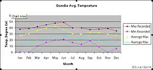
Gondia experiences extreme variations in temperature with very hot summers and very cold winters and has an average relative humidity of 62 percent. Average recorded rainfall is more than 1,200 mm (47 in) in each rainy season (June to September).
The hottest month is May when daytime high temperatures will generally average 42 °C (108 °F). During the same month, nightly minimum temperatures average around 28 °C (82 °F). In recent times the highest-recorded temperature in May has been 48 °C (118 °F), and the lowest May temperature has been 20 °C (68 °F).
The coolest months are December and January when temperatures will reach highs of around 29 °C (84 °F) and lows of 13 °C (55 °F). The highest-recorded temperature in January was 38 °C (100 °F) and the lowest was 0 °C (32 °F).
| Climate data for Gondia | |||||||||||||
|---|---|---|---|---|---|---|---|---|---|---|---|---|---|
| Month | Jan | Feb | Mar | Apr | May | Jun | Jul | Aug | Sep | Oct | Nov | Dec | Year |
| Average high °C (°F) | 27.6 (81.7) |
31.1 (88.0) |
35.2 (95.4) |
43.0 (109.4) |
47.0 (116.6) |
45.0 (113.0) |
30.5 (86.9) |
29.9 (85.8) |
30.8 (87.4) |
31.0 (87.8) |
29.3 (84.7) |
27.9 (82.2) |
34.0 (93.2) |
| Average low °C (°F) | 13.3 (55.9) |
15.4 (59.7) |
19.6 (67.3) |
24.6 (76.3) |
28.9 (84.0) |
27.4 (81.3) |
24.3 (75.7) |
24.1 (75.4) |
23.9 (75.0) |
21.2 (70.2) |
15.2 (59.4) |
9 (48) |
20.6 (69.0) |
| Average precipitation mm (inches) | 18.0 (0.71) |
30.7 (1.21) |
16.0 (0.63) |
16.0 (0.63) |
13.7 (0.54) |
219.2 (8.63) |
503.9 (19.84) |
443.5 (17.46) |
222.3 (8.75) |
66.5 (2.62) |
22.9 (0.90) |
5.8 (0.23) |
1,578.5 (62.15) |
| Source: Government of Maharashtra | |||||||||||||
Economy
Gondia is also known as "rice City", as it is a rice-producing district and has about 250 rice mills in its vicinity. It is also a major trading place. The Mumbai–Nagpur–Kolkata Road is the only national highway passing through the district, covering a total distance of 99.37 km (62 mi). Gondia has bus connectivity to Jabalpur, Nagpur, Raipur and Hyderabad.
In 2006 the Ministry of Panchayati Raj named Gondia one of the country's 250 most backward districts (out of a total of 640).[8] It is one of the twelve districts in Maharashtra currently receiving funds from the Backward Regions Grant Fund Programme (BRGF).[8]
References
- "Archived copy". Archived from the original on 27 July 2007. Retrieved 27 August 2018.CS1 maint: archived copy as title (link)
- "Districtwise List of Assembly and Parliamentary Constituencies". Chief Electoral Officer, Maharashtra website. Archived from the original on 18 March 2010. Retrieved 31 March 2009.
- "District Census 2011". Census2011.co.in. 2011. Retrieved 30 September 2011.
- US Directorate of Intelligence. "Country Comparison:Population". Retrieved 1 October 2011.
Mauritius 1,303,717 July 2011 est.
- "2010 Resident Population Data". U. S. Census Bureau. Archived from the original on 21 July 2011. Retrieved 30 September 2011.
New Hampshire 1,316,470
- "C-16 Population By Mother Tongue – Maharashtra". censusindia.gov.in. Retrieved 4 October 2019.
- "Census of India Website : Office of the Registrar General & Census Commissioner, India". www.censusindia.gov.in. Retrieved 11 January 2020.
- Ministry of Panchayati Raj (8 September 2009). "A Note on the Backward Regions Grant Fund Programme" (PDF). National Institute of Rural Development. Archived from the original (PDF) on 5 April 2012. Retrieved 27 September 2011.
External links
| Wikimedia Commons has media related to Gondia district. |
Places adjacent to Gondia district | ||||||||||
|---|---|---|---|---|---|---|---|---|---|---|
| ||||||||||
| Districts of Vidarbha | |
|---|---|
| Cities with municipal corporations | |
Portal:India | |
| Topics | |||||||||||||
|---|---|---|---|---|---|---|---|---|---|---|---|---|---|
| Regions | |||||||||||||
| Divisions and Districts |
| ||||||||||||
| Million-plus cities in Maharashtra | |||||||||||||
| Other cities with municipal corporations | |||||||||||||
Portal:India | |||||||||||||