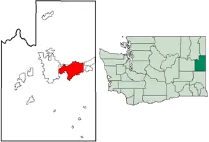
Spokane Valley, Washington
Spokane Valley is a city in Spokane County, Washington, United States, and the largest suburb of Spokane. It is located east of Spokane, west of Coeur d'Alene, Idaho and surrounds the city of Millwood on three sides. The city incorporated as the City of Spokane Valley on March 31, 2003. The Washington State Office of Financial Management estimates the city's population as 101,060 as of 2019.[7] Spokane Valley is named after the valley of the Spokane River, in which it is located. Before becoming an incorporated city, the area was and still is referred to as "The Valley" by residents of the Spokane–Coeur d'Alene area.
Spokane Valley, Washington | |
|---|---|
| City of Spokane Valley | |
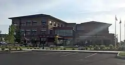 Spokane Valley City Hall | |
 Logo | |
| Nickname(s): The Valley | |
| Motto(s): "A community of opportunity where individuals and families can grow and play, and businesses will flourish and prosper." | |
 | |
| Coordinates: 47°40′24″N 117°14′22″W | |
| Country | United States |
| State | Washington |
| County | Spokane |
| Settled | 1849 |
| Incorporated | March 31, 2003 |
| Named for | The Spokane Valley |
| Government | |
| • Type | Council–manager |
| • Body | City council |
| • City manager | Mark Calhoun |
| • Mayor | Ben Wick |
| • Deputy mayor | Brandi Peetz |
| Area | |
| • City | 38.01 sq mi (98.44 km2) |
| • Land | 37.72 sq mi (97.69 km2) |
| • Water | 0.29 sq mi (0.75 km2) |
| Elevation | 2,002 ft (610 m) |
| Population | |
| • City | 89,755 |
| • Estimate (2019)[3] | 101,060 |
| • Rank | US: 312th WA: 9th |
| • Density | 2,679.22/sq mi (1,034.46/km2) |
| • Metro | 573,493 (US: 98th) |
| • CSA | 721,396 (US: 72nd) |
| Time zone | UTC−8 (Pacific (PST)) |
| • Summer (DST) | UTC−7 (PDT) |
| ZIP code | 99206, 99216, 99212, 99016, 99027, 99037 [4] |
| Area code(s) | 509 |
| FIPS code | 53-67167[5] |
| GNIS feature ID | 1967430[6] |
| Website | Official website |
History
The City of Spokane Valley incorporated on March 31, 2003.[8] At its creation, it was the third-largest newly incorporated city in US history (after Centennial, Colorado, which incorporated in 2001; and Miami Gardens, Florida, which incorporated about five weeks before Spokane Valley).
The city formed from combining the urbanized unincorporated areas east of Spokane City, including census-designated places (CDPs) of Dishman, Opportunity, Trentwood, Veradale, part of Greenacres, and East Spokane. The new city boundaries did not include the incorporated areas such as Millwood and Liberty Lake, nor the protected areas such as the Dishman Hills Natural Area. It was initially delayed by a petition from Spokane, because it included the Yardley industrial area, to which Spokane had already extended utilities, and had plans to annex. Prior to the successful vote May 21, 2002, there had been four failed attempts to form a city in the Valley. The main arguments for incorporation centered around increased voice in local governance and the threat of annexation by the City of Spokane. The main arguments against incorporation included contentment with Spokane County provided services and the threat of increased taxes and bureaucracy by the new city. Both sides claimed their opponents arguments were entirely untrue scare tactics.[9][10]
Geography

Spokane Valley lies along both banks of the Spokane River as it flows between Idaho and the City of Spokane. Most of the city lies to the south of the river as the Selkirk Mountains rise immediately to the north of the river in most places. To the south of the valley rise Mica Peak and Krell Hill, the southernmost extremity of the Selkirks.
Shelley Lake is a small lake located entirely in city limits, fed by the Saltese Creek.
Spokane Valley city proper consists of the communities of Dishman, Greenacres, Opportunity, Trentwood, Veradale, Yardley, and parts of Chester and Otis Orchards. According to the United States Census Bureau, the city has a total area of 38.06 square miles (98.57 km2), of which, 37.77 square miles (97.82 km2) is land and 0.29 square miles (0.75 km2) is water.[11]
Because the City of Spokane Valley shares its name with the unincorporated area it was carved from, the term "Spokane Valley" is often used in reference to an area greater than that which falls within the city limits.
Cityscape

Climate
Spokane Valley experiences a Hot-summer mediterranean climate (Köppen Csa), or a Humid continental climate (Dsa) depending on the temperature threshold used.
| Climate data for Spokane (Felts Field) 1998-present normals and extremes | |||||||||||||
|---|---|---|---|---|---|---|---|---|---|---|---|---|---|
| Month | Jan | Feb | Mar | Apr | May | Jun | Jul | Aug | Sep | Oct | Nov | Dec | Year |
| Record high °F (°C) | 59 (15) |
60 (16) |
74 (23) |
87 (31) |
95 (35) |
108 (42) |
112 (44) |
112 (44) |
102 (39) |
86 (30) |
69 (21) |
63 (17) |
112 (44) |
| Mean maximum °F (°C) | 51.5 (10.8) |
53.4 (11.9) |
64.9 (18.3) |
76.2 (24.6) |
86.6 (30.3) |
93.5 (34.2) |
100.3 (37.9) |
99.2 (37.3) |
90.6 (32.6) |
75.3 (24.1) |
59.6 (15.3) |
51.6 (10.9) |
101.9 (38.8) |
| Average high °F (°C) | 37.1 (2.8) |
42.5 (5.8) |
51.0 (10.6) |
59.0 (15.0) |
68.6 (20.3) |
75.2 (24.0) |
87.0 (30.6) |
85.6 (29.8) |
75.6 (24.2) |
60.2 (15.7) |
44.8 (7.1) |
36.6 (2.6) |
60.3 (15.7) |
| Average low °F (°C) | 26.2 (−3.2) |
27.2 (−2.7) |
31.7 (−0.2) |
36.2 (2.3) |
43.3 (6.3) |
50.3 (10.2) |
56.2 (13.4) |
54.8 (12.7) |
46.6 (8.1) |
37.9 (3.3) |
30.6 (−0.8) |
25.6 (−3.6) |
38.9 (3.8) |
| Mean minimum °F (°C) | 9.3 (−12.6) |
13.8 (−10.1) |
20.4 (−6.4) |
26.8 (−2.9) |
32.0 (0.0) |
41.3 (5.2) |
46.4 (8.0) |
45.5 (7.5) |
36.0 (2.2) |
25.6 (−3.6) |
17.1 (−8.3) |
9.4 (−12.6) |
2.5 (−16.4) |
| Record low °F (°C) | −10 (−23) |
−3 (−19) |
2 (−17) |
24 (−4) |
28 (−2) |
37 (3) |
39 (4) |
40 (4) |
26 (−3) |
12 (−11) |
−2 (−19) |
−10 (−23) |
−10 (−23) |
| Average precipitation inches (mm) | 1.92 (49) |
1.14 (29) |
1.91 (49) |
1.23 (31) |
1.51 (38) |
1.66 (42) |
0.40 (10) |
0.51 (13) |
0.61 (15) |
1.10 (28) |
1.94 (49) |
2.31 (59) |
16.25 (413) |
| Source 1: [12] | |||||||||||||
| Source 2: [13] | |||||||||||||
Demographics
| Historical population | |||
|---|---|---|---|
| Census | Pop. | %± | |
| 2000 | 80,927 | — | |
| 2010 | 89,755 | 10.9% | |
| 2019 (est.) | 101,060 | [3] | 12.6% |
| U.S. Decennial Census[14] 2018 Estimate[15] | |||
2010 census
As of the census[2] of 2010, there were 89,755 people, 36,558 households, and 23,119 families residing in the city. The population density was 2,376.4 inhabitants per square mile (917.5/km2). There were 38,851 housing units at an average density of 1,028.6 per square mile (397.1/km2). The racial makeup of the city was 90.9% White, 1.1% African American, 1.2% Native American, 1.7% Asian, 0.3% Pacific Islander, 1.4% from other races, and 3.3% from two or more races. Hispanic or Latino of any race were 4.6% of the population.
There were 36,558 households, of which 31.6% had children under the age of 18 living with them, 45.6% were married couples living together, 12.2% had a female householder with no husband present, 5.4% had a male householder with no wife present, and 36.8% were non-families. 29.0% of all households were made up of individuals, and 11.2% had someone living alone who was 65 years of age or older. The average household size was 2.43 and the average family size was 2.99.
The median age in the city was 37.3 years. 24% of residents were under the age of 18; 9.5% were between the ages of 18 and 24; 26.1% were from 25 to 44; 26.4% were from 45 to 64; and 14.1% were 65 years of age or older. The gender makeup of the city was 48.9% male and 51.1% female.
Infrastructure
Emergency services
The Spokane Valley Police Department is a contracted division of the Spokane County Sheriff's Office, with Spokane Valley being the largest city the sheriff's office serves.[16] Deputies assigned to the Spokane Valley Precinct use distinct patrol vehicles and uniforms, including a Spokane Valley Police Department patch. Since 2016, the city's chief of police has been Mark Werner.[17] The Spokane Valley Police Department has been a Washington Association of Sheriffs and Police Chiefs accredited agency since 2011.[18] The Spokane County Sheriff's Office has been featured in 26 episodes of the A&E Television series Live PD,[19] with the majority of filming happening in or near the City of Spokane Valley.[20]
The Spokane Valley Fire Department (SVFD) has served the greater Spokane Valley area since 1940.[21] SVFD is a special purpose fire district that was formed 63 years before the incorporation of the City of Spokane Valley, and as result is a separate entity from the city. SVFD has seven fire stations located in the City of Spokane Valley,[22] and remaining three others in Liberty Lake, Millwood, and Otis Orchards. An eighth fire station serving Spokane Valley is planned to open in 2022.[23]
Ambulance service in Spokane Valley is currently contracted to American Medical Response.[24]
Education
Spokane Valley is served by multiple school districts, including the Central Valley School District, West Valley School District, East Valley School District, and a portion of western Spokane Valley by Spokane Public Schools.[25] Private schools include Valley Christian School (which occupies the former campus of Spokane University), St. John Vianney School, The Oaks Classical Christian Academy, and several others. High School students may also attend Spokane Valley Tech, a public vocational school serving the Spokane Valley and greater Spokane region.[26]
Spokane Valley higher education includes a small campus of Carrington College.[27]
Culture
Art
The Spokane Valley Arts Council (a 501c3) works to connect business, government and local artists. It maintains an exhibit of local artists in the CenterPlace Regional Event Center foyer, commissions sculptures and monuments for community parks and buildings, and sponsors an Artist Showcase Auction and Fundraiser each October.[28][29]
Museums
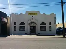
The Spokane Valley Heritage Museum opened its doors on August 18, 2005,[30] and is located in the historic Opportunity Township Hall. The museum's goal is to collect, preserve and exhibit the history and culture of the Spokane Valley. The museum houses archives of photos and documents, as well as public exhibits.[31]
Sports

Spokane Valley is the home of the Spokane Indians, a Minor League Baseball team of the Northwest League (NWL) and Class A Short Season affiliate of the Texas Rangers. The Indians play its home games at Avista Stadium, which opened in 1958 and has a seating capacity of 6,803.[32] From 1958 through 1982, excluding 1972, the Indians were in the Triple-A Pacific Coast League (PCL). They have won 12 league titles: four in the PCL and eight in the NWL.[33] The Spokane region has over a century of history in Minor League Baseball, dating back to the 1890s.[34]
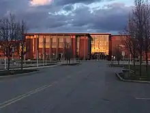
Fair & Expo Center
The Spokane County Fair and Expo Center is home to dozens of various events throughout the year,[35] including the 10-day Spokane County Interstate Fair.[36] The Fair & Expo Center is situated on 97 acres, with over 140,000 square feet of exhibition space, livestock facilities, indoor and outdoor arenas, lawns, and parking.[37]
Valleyfest
Valleyfest is a 3-day community festival held every September since 1990 at Mirabeau Point Park and CenterPlace Regional Event Center. Events include the Hearts of Gold Parade, hot air balloon launches, 5K/10K Run for Hunger, Pancake Breakfast, Classic Car Show, Kids Zone, 3 stages of live music, Miss Spokane Valley Scholarship Program, and much more. Attendance each year is estimated at over 50,000 people, with over 150 exhibits, and 200+ volunteers.[38]
Neighborhoods and Communities
Spokane Valley was formed in 2003 from unincorporated communities, many of which had long and unique histories prior to the city. Some are still present as neighborhoods, while others faded away.
- Austin
- Chester
- Dishman
- East Spokane
- Greenacres
- Irwin
- Opportunity
- Orchard Avenue
- Trentwood
- Velox
- Veradale
- Yardley
References
- "2019 U.S. Gazetteer Files". United States Census Bureau. Retrieved August 7, 2020.
- "U.S. Census website". United States Census Bureau. Retrieved December 19, 2012.
- "Annual Estimates of the Resident Population for Incorporated Places in Washington: April 1, 2010 to July 1, 2019". United States Census Bureau. May 2020. Retrieved May 27, 2020.
- "Spokane Valley, Washington Zip Code Boundary Map (WA)". www.zipmap.net.
- "US Gazetteer files: 2010, 2000, and 1990". United States Census Bureau. February 12, 2011. Retrieved April 23, 2011.
- "US Board on Geographic Names". United States Geological Survey. December 23, 2002. Retrieved March 13, 2017.
- "Annual Estimates of the Resident Population for Incorporated Places in Washington: April 1, 2010 to July 1, 2019". United States Census Bureau. May 2020. Retrieved May 26, 2020.
- "History of the Spokane Valley". Spokane.net. Archived from the original on 2 December 2009. Retrieved 12 July 2009.
- Hutson, Lorie (18 May 2002). "Ads for Valley city called misleading". Spokane, Wa. The Spokesman-Review. p. B1.
- "Incorporation 101" (Valley Voice). The Spokesman-Review. 18 May 2002. pp. 4–8.
- "US Gazetteer files 2010". United States Census Bureau. Archived from the original on July 2, 2012. Retrieved 2012-12-19.
- "NOWData - NOAA Online Weather Data". NOAA. Retrieved February 25, 2018.
- "THE SUMMERS OF 1939, 1961 AND 1967 WERE THE HOTTEST EVER IN COEUR D'ALENE". Coeur d'Alene Press. Archived from the original on November 17, 2018. Retrieved February 26, 2018.
- United States Census Bureau. "Census of Population and Housing". Retrieved August 3, 2013.
- "Population Estimates". United States Census Bureau. Retrieved June 5, 2019.
- "Police - Spokane Valley, WA". www.spokanevalley.org.
- "Spokane Valley Police Chief - Undersheriff Mark Werner | Spokane County, WA". Spokane County.
- Huffman, Mike (11 Dec 2015). "Spokane Valley Police Department earns reaccreditation". The Spokane Valley News Herald. Retrieved 18 August 2020.
- Flynn, Caroline (August 8, 2017). "Spokane County Sheriff's Office featured on "Live PD"". www.kxly.com. Retrieved 2020-01-11.
- "Shawn Vestal: 'Live PD' paints Spokane at its ugliest". The Spokesman-Review.
- "OUR HISTORY". Spokane Valley Fire Department. Retrieved July 6, 2019.
- "FACILITIES & APPARATUS". Spokane Valley Fire Department. Retrieved July 6, 2019.
- "MAINTENANCE & OPERATIONS (M&O) REPLACEMENT LEVY". Spokane Valley Fire Department. Retrieved July 6, 2019.
- "AMR in the Spokane Community". American Medical Response. Retrieved July 6, 2019.
- Spokane County GIS (February 2019). Spokane County School Districts (Map). Spokane County Building and Planning. Retrieved August 17, 2020.
- "Spokane Valley Tech". www.spokanevalleytech.org. Retrieved August 17, 2020.
- "Carrington College". Carrington College.
- "Visitors". Spokane Valley. City of Spokane Valley. Retrieved 18 August 2020.
- "Spokane Valley Arts Council". Spokane Valley Arts Council. Retrieved 18 August 2020.
- Yahya, Ayisha. Spokane Valley Museum brings a blast from past . The Spokesman-Review, August 19, 2005, http://www.spokesman.com/stories/2005/aug/19/spokane-valley-museum-brings-a-blast-from-past/
- "Archived copy". Archived from the original on 2008-05-17. Retrieved 2015-02-18.CS1 maint: archived copy as title (link)
- "Official website" (PDF). www.spokesman.com. Retrieved 2020-01-11.
- "Spokane Indians History". MiLB.com.
- Price, Jim (June 21, 2003). "Birth of the Indians". Spokesman-Review. Spokane Valley, Washington. p. H2.
- "Fair & Expo Center | Spokane County, WA". www.spokanecounty.org.
- "Interstate Fair | Spokane County, WA". www.spokanecounty.org.
- "Spokane County Fair & Expo Center". Spokane County, WA.
- "About Valleyfest > Valleyfest".
External links
Municipalities and communities of Spokane County, Washington, United States | ||
|---|---|---|
| Cities | 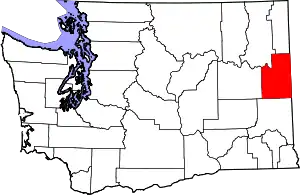 Map of Washington highlighting Spokane County | |
| Towns | ||
| CDPs | ||
| Unincorporated communities | ||
| Ghost towns/Neighborhoods | ||
| ||
| Authority control |
|---|