Kent, Washington
Kent is a city located in King County, Washington, United States. The sixth largest city in the state, Kent is in the heart of the Seattle–Tacoma metropolitan area. Kent is connected to Seattle, Bellevue and Tacoma via State Route 167, Interstate 5, and the Sounder commuter rail network. Incorporated in 1890, it is the second oldest incorporated city in King County, after Seattle.[6] Kent's population as of April 2010 was 92,411 according to the 2010 census. Annexation on July 1, 2010 increased the population by 11,000.[7][8] Kent is generally divided into 3 sections: West Hill (mixed residential and commercial along Interstate 5), Valley (primarily industrial and commercial with some medium density residential; significant parkland along Green River), and East Hill (primarily residential with retail).
Kent, Washington | |
|---|---|
City | |
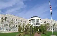
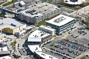 Kent Station, Kent Regional Library top right, and Kent Sounder Station 2009 | |
Flag | |
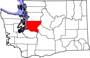
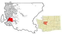 Location of Kent, Washington in King County | |
 Kent, Washington Location in the United States | |
| Coordinates: 47°22′58″N 122°13′37″W | |
| Country | United States |
| State | Washington |
| County | King |
| Incorporated | May 28, 1890 |
| Government | |
| • Type | Mayor-council government |
| • Mayor | Dana Ralph[1] |
| Area | |
| • Total | 34.42 sq mi (89.14 km2) |
| • Land | 33.75 sq mi (87.41 km2) |
| • Water | 0.67 sq mi (1.73 km2) |
| Elevation | 43–500 ft (13−152 m) |
| Population | |
| • Total | 92,411 |
| • Estimate (2019)[4] | 132,319 |
| • Rank | US: 213th |
| • Density | 3,920.56/sq mi (1,513.75/km2) |
| Time zone | UTC-8 (PST) |
| • Summer (DST) | UTC-7 (PDT) |
| ZIP codes | 98030, 98031, 98032, 98035, 98042, 98064, 98089 |
| Area code(s) | 253 |
| FIPS code | 53-35415 |
| GNIS feature ID | 1530952[5] |
| Website | KentWA.gov |
History
The Kent area was first permanently settled by European Americans in the 1850s along the banks of what was then the White River. The first settler was Samuel Russell, who sailed the White and Duwamish rivers until he claimed a plot of land southeast of modern-day downtown Kent in the spring of 1853. Russell was followed by several other settlers who quickly staked claims around the area.[9] The settlements were originally known as "White River" and later the town was called "Titusville" after an early settler by the name of James Henry Titus.[10] (There is still a "Titusville Station" sign on Gowe Street near First Avenue). In 1861 a post office was established under the name White River and was located at the farm of David and Irena Neely who settled in modern-day Kent in 1854. In 1855 their farm was attacked by Native Americans when David Neely served as a lieutenant in the Territorial Army. Another settler was Henry L. Yesler, who was the first sawmill operator in Seattle.[11] By 1870 the population was 277 and all of the quality bottom-land had been claimed.[12]
Throughout the 1860s and 70's, grain and forage crops such as wheat, barley, oats, hay, and timothy accounted for much of the annual return of farmers in the valley. During the late 1870s the town discovered hops production as a major source of income.[13] Due to an aphid invasion which affected hops crops in Europe,[14] hops from the Puget Sound area began to command high prices. Hops were shipped from Titusville either by the river or via rail. In 1889 the town was renamed for the County of Kent, the major hops-producing region in England. Ezra Meeker was asked by the Northern Pacific Railroad to name its station. Meeker suggested that it be known as Kent as it was "Hop Capitol of the West".[11] Hops production in the White River valley came to an end soon after its own invasion of aphids in 1891.[15]
Kent was officially incorporated on May 28, 1890, with a population of 793, the second city incorporated in King County.[16] Seattle was the first.
After the turn of the 20th century the area turned to dairy farming and was home to a Carnation condensed milk plant.[17][18] Flooding from both the Green and the White Rivers was a constant problem. In 1906, flooding changed the course of the White River, which reduced the flood hazard by half. The Green River continued to present problems until the creation of the Howard A. Hanson Dam at Eagle Gorge in 1962.[19][20]
During and after the Great Depression, Kent was known as the "Lettuce Capital of the World".[21] After WWII, Kent began to grow more rapidly. From 1953 to 1960 the city's size grew twelve-fold. In 1965 Boeing began building in Kent, followed a few years later by other aerospace and high-tech companies.[22]
In 1992, the Greater Kent Historical Society was formed to promote the discovery, preservation and dissemination of knowledge about the history of the greater Kent area.[23] In 1996, the City of Kent purchased the historic Bereiter house, the home of one of Kent's early mayors, for use as the Kent Historical Museum. The museum is operated by the Greater Kent Historical Society.[24]
Geography
Kent is divided into three major regions: East Hill, the Valley, and West Hill. Downtown Kent is located on the east side of the valley; the rest of the valley is almost entirely covered by warehouses. Mt. Rainier is a prominent geographical landmark to the southeast.
According to the United States Census Bureau, the city has a total area of 29.19 square miles (75.60 km2), of which, 28.63 square miles (74.15 km2) is land and 0.56 square miles (1.45 km2) is water.[25] Major waterways include the Green River, which flows north through Kent on its way to Puget Sound. The largest lake is Lake Meridian on the city's East Hill.
Nearby cities include Renton and Tukwila to the north, Covington and Maple Valley to the east, Auburn to the south, and Federal Way, Des Moines and SeaTac to the west.
Kent is located 19 miles south of Seattle, 17 miles southwest of Bellevue, and 19 miles northeast of Tacoma.
Transportation
There are several major freeways and highways in or near Kent, including Interstate 5, State Route 167, State Route 516, State Route 18, and State Route 99, which produce high traffic density during rush hour. Kent is also central to King County Metro transit, with the Kent Station providing service to many destinations, including downtown Seattle by multiple commuter buses, the Sounder Commuter Rail, and local bus service. Heavy rail service includes two major north–south lines through the Kent Valley, with freight traffic operations by the BNSF and Union Pacific railroads. In 2024, the Link light rail system will be extended south to Federal Way with an intermediate stop at Kent/Des Moines station near Highline College.[26]
Parks
Kent's park system includes 73 parks, miniparks, playfields, skateparks, greenbelts, and other related facilities. These parks range in size from as little as 4,300 square feet (400 m2) to over 310 acres (1.3 km2).[27]
Climate
| Climate data for Kent, Washington | |||||||||||||
|---|---|---|---|---|---|---|---|---|---|---|---|---|---|
| Month | Jan | Feb | Mar | Apr | May | Jun | Jul | Aug | Sep | Oct | Nov | Dec | Year |
| Record high °F (°C) | 64 (18) |
71 (22) |
81 (27) |
86 (30) |
92 (33) |
100 (38) |
103 (39) |
99 (37) |
96 (36) |
86 (30) |
74 (23) |
69 (21) |
103 (39) |
| Average high °F (°C) | 47 (8) |
51 (11) |
55 (13) |
61 (16) |
67 (19) |
72 (22) |
77 (25) |
78 (26) |
72 (22) |
62 (17) |
52 (11) |
46 (8) |
62 (17) |
| Average low °F (°C) | 32 (0) |
36 (2) |
39 (4) |
42 (6) |
47 (8) |
52 (11) |
55 (13) |
55 (13) |
51 (11) |
44 (7) |
39 (4) |
34 (1) |
44 (7) |
| Record low °F (°C) | −10 (−23) |
−5 (−21) |
10 (−12) |
25 (−4) |
27 (−3) |
33 (1) |
38 (3) |
34 (1) |
28 (−2) |
24 (−4) |
−1 (−18) |
3 (−16) |
−10 (−23) |
| Average precipitation inches (mm) | 5.3 (130) |
4.5 (110) |
4.1 (100) |
2.9 (74) |
2.1 (53) |
1.7 (43) |
0.9 (23) |
1.2 (30) |
1.8 (46) |
3.4 (86) |
6.1 (150) |
5.8 (150) |
37.1 (940) |
| Source: Weather.com[28] | |||||||||||||
City landmarks
Kent has designated the following landmarks:[29]
| Name | Constructed | Designated |
|---|---|---|
| Lunar Roving Vehicles | 1970 | 2019[30] |
| Emil W. Bereiter House | 1907 | 2008 |
| Mill Creek Canyon Earthworks | 1982 | 2008 |
| Saar Pioneer Cemetery | 1873 | 2010 |
Government
| Year | Republican | Democratic | Third Parties |
|---|---|---|---|
| 2020 | 32.32% 18,219 | 64.50% 36,359 | 3.18% 1,795 |
The city is governed by a mayor–council government, with a directly elected mayor and a seven-member city council. Each is elected at-large (that is, by the entire voting population, rather than by districts) to four-year terms. The current Mayor is Dana Ralph and the current city council members are: [32] Council President Bill Boyce, Councilmember Satwinder Kaur, Councilmember Marli Larimer, Councilmember Brenda Fincher, Councilmember Dennis Higgins, Councilmember Toni Troutner, and Councilmember Les Thomas.[33]
The city maintains its own municipal police department.
Public education
Public primary and secondary education in Kent and a number of neighboring cities and unincorporated areas is governed by the Kent School District. The district includes four high schools, seven middle schools, twenty-eight elementary schools and two academies. Federal Way Public Schools also has several schools within the city limits. Residents of far east Kent are zoned in the Tahoma School district. A branch of Green River Community College opened in Kent Station in 2007.[34] The Kent School District also has an individualized graduation and degree program named iGrad. The program is aimed at dropouts aged 16–21 who are willing to get back to school.[35]
Annexation
In keeping with the King County Annexation Initiative, which seeks to annex large urban unincorporated areas into city limits or incorporate new cities out of those areas,[36] the Panther Lake area (known officially as the Kent Northeast Potential Annexation Area)[37] was proposed for annexation to the city of Kent. The annexation was voted on by residents of the potential annexation area on November 3, 2009; the area was officially annexed July 1, 2010.[38] The city grew in area by approximately 5 square miles (13 km2) and 24,000 residents.[38]
Economy
In addition to REI, Oberto Sausage Company, and Seattle Bicycle Supply (owner of Redline Bicycles) all being headquartered in Kent, both Amazon and Boeing operate facilities in the city. Kent also hosts many warehouses, due in part to its proximity to key transportation routes. It is also home to the two largest waterjet companies in the United States: Flow International Corporation and Omax Corporation, as well as aerospace manufacturer Blue Origin. The warehouse district has grown rapidly in recent years. Whirlpool Corporation and General Electric Appliances are two companies with regional distribution centers in Kent.
To honor the 100th anniversary of Oberto Sausage Company's presence in the city, Kent designated a section of South 238th Street as Oberto Drive in May 2018.[39]
Kent is home to the fourth largest manufacturing and distribution area in the United States.[40]
Boeing
Boeing Kent Space Center was opened with a public dedication ceremony on October 24, 1964. Keynote speakers at the event were William "Bill" Allen, Chairman and CEO of The Boeing Company; future Washington Governor Dan Evans; and Alex Thorton, Mayor of the City of Kent. The event featured public tours of the labs and facilities that were used to build the lunar rovers used in the Apollo program.[41]
Steel
Kent is home to a large steel industry dating back to the early 20th century.[42][43] Steel and metal manufacturers include:
- Salmon Bay Steel Company: Operated in Kent for 50 years before closing down. Birmingham Steel purchased Salmon bay in 1991. Salmon bay went on to buy Bethlehem Steel (Seattle Steel) in West Seattle. Years after the purchase, complaints were made of pollution in the Green River valley about pollution from the Salmon Bay melting facility and the facility was shut down.[44]
- Puget Sound Steel: Puget Sound Steel is an independently owned and operated-unique specialty fabricator of reinforcing steel and a supplier of related reinforcement products, since 1961. Puget Sound Steel has been the Northwest's select supplier of fabricated rebar, and steel reinforcement to commercial, highway, industrial and residential building contractors. Works include large scale projects including bridges skyscrapers.[45][46]
- Pacific Metal Company: In 1947, started in Seattle and opened a 19,000 square foot plant. The business and facilities continued to grow for 30 years to meet local needs as well as the emerging markets of Alaska. The "expanded" 40,000 square foot warehouse and sales office was bursting its seams.. In 1979, an 80,000 square foot facility was built south of the city of Seattle in the Kent Valley at Tukwila. In September 2010 PMC moved to a new location just 3 miles SE in the city of Kent, Washington. Pacific Metal Company is a stocking distributor of non-ferrous metals specializing in stainless steel, copper, aluminum, and brass products as well as ferrous products specializing in Cold Rolled, Coated (Zinc and Aluminum) and pre-painted coils and sheets.[47]
- TMX Aerospace: TMX Aerospace, a division of ThyssenKrupp Steel North America; provides materials including steel, brass, and copper as well as exclusive supply chain management support for the Boeing Commercial Airplanes group.[48][49]
Largest employers
According to the city's 2018 Comprehensive Annual Financial Report,[50] the largest employers in the city are:
| # | Employer | # of Employees |
|---|---|---|
| 1 | Amazon | 4,264 |
| 2 | Kent School District | 2,930 |
| 3 | Boeing | 2,480 |
| 4 | Exotic Metals Forming Co. | 1,186 |
| 5 | Blue Origin | 1,031 |
| 6 | REI | 874 |
| 7 | Carlisle Interconnect Industries | 845 |
| 8 | City of Kent | 715 |
| 9 | Alaska Airlines | 647 |
| 10 | King County (Maleng Regional Justice Center) | 630 |
Demographics
| Historical population | |||
|---|---|---|---|
| Census | Pop. | %± | |
| 1890 | 853 | — | |
| 1900 | 755 | −11.5% | |
| 1910 | 1,908 | 152.7% | |
| 1920 | 2,282 | 19.6% | |
| 1930 | 2,320 | 1.7% | |
| 1940 | 2,586 | 11.5% | |
| 1950 | 3,278 | 26.8% | |
| 1960 | 9,017 | 175.1% | |
| 1970 | 17,711 | 96.4% | |
| 1980 | 22,961 | 29.6% | |
| 1990 | 37,960 | 65.3% | |
| 2000 | 79,524 | 109.5% | |
| 2010 | 92,411 | 16.2% | |
| 2019 (est.) | 132,319 | [4] | 43.2% |
2010 census
As of the census[3] of 2010, there were 92,411 people, 34,044 households, and 21,816 families residing in the city. The population density was 3,227.8 inhabitants per square mile (1,246.3/km2). There were 36,424 housing units at an average density of 1,272.2 per square mile (491.2/km2). The racial makeup of the city was 55.5% White (49.7% Non-Hispanic White), 11.3% African American, 1.0% Native American, 15.2% Asian, 1.9% Pacific Islander, 8.5% from other races, and 6.6% from two or more races. Hispanic or Latino of any race were 16.6% of the population.
There were 34,044 households, of which 37.0% had children under the age of 18 living with them, 43.6% were married couples living together, 14.3% had a female householder with no husband present, 6.1% had a male householder with no wife present, and 35.9% were non-families. 28.1% of all households were made up of individuals, and 7.5% had someone living alone who was 65 years of age or older. The average household size was 2.67 and the average family size was 3.31.
The median age in the city was 33 years. 26.2% of residents were under the age of 18; 10.1% were between the ages of 18 and 24; 30.6% were from 25 to 44; 24.3% were from 45 to 64; and 8.8% were 65 years of age or older. The gender makeup of the city was 49.9% male and 50.1% female.
2000 census
As of the census of 2000, there were 79,524 people, 31,113 households, and 19,601 families residing in the city. The population density was 2,836.7 people per square mile (1,095.4/km2). There were 32,488 housing units at an average density of 1,158.9 per square mile (447.5/km2). The racial makeup of the city was 70.81% White, 8.23% African American, 0.98% Native American, 9.42% Asian, 0.76% Pacific Islander, 4.7% from other races, and 5.37% from two or more races. Hispanic or Latino of any race were 8.13% of the population.
There were 32,998 households, out of which 35.5% had children under the age of 18 living with them, 45.1% were married couples living together, 12.8% had a female householder with no husband present, and 37.0% were non-families. 28.5% of all households were made up of individuals, and 5.8% had someone living alone who was 65 years of age or older. The average household size was 2.53 and the average family size was 3.15.
In the city the population was spread out, with 27.7% under the age of 18, 10.3% from 18 to 24, 35.0% from 25 to 44, 19.6% from 45 to 64, and 7.3% who were 65 years of age or older. The median age was 32 years. For every 100 females, there were 98.4 males. For every 100 females age 18 and over, there were 96.2 males.
The median income for a household in the city was $50,053, and the median income for a family was $61,016. Males had a median income of $43,136 versus $36,995 for females. The per capita income for the city was $21,390. About 8.7% of families and 11.6% of the population were below the poverty line, including 16.7% of those under the age of 18 and 9.3% of those 65 and older.
Recreation and entertainment
In 2003, Kent was named Sports Illustrated's Sportstown of the year for Washington. In January 2006, an entertainment center, known as Kent Station, opened in downtown Kent adjacent to the transit station of the same name.
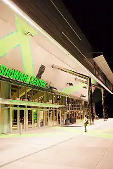
The 2012 Skate America figure skating competition was held in Kent from October 19 to 21, 2012,[52][53] at ShoWare Center.[54]
In July 2015, Kent hosted the inaugural Junior Roller Derby World Cup.[55]
Riverbend Golf Complex, featuring an 18-hole course which is one of the busiest in Washington state, is located in Kent. An adjacent par 3 course was actively used by locals for years before being shut down in 2017 to make room for a mixed used development.[56]
Events
- Canterbury Faire, an arts festival in mid-August every year at Mill Creek Canyon Earthworks park, which stopped in 2006.
- Kent Cornucopia Days in July.
- Kent Farmers Market
- Kent Saturday Market
Entertainment
- Kent Station
- accesso ShoWare Center
- Seattle Thunderbirds play ice hockey in the U.S. Division of the Western Hockey League at the ShoWare Center in Kent.[57]
- Tacoma Stars plays Indoor Soccer in the Major Arena Soccer League at the ShoWare Center in Kent.
The people of Kent are also often fans of the Seattle Seahawks an NFL team, the Seattle Sounders FC, a MLS team, and the Seattle Mariners, an MLB team. They could also be counted as fans of the former NBA team the Seattle SuperSonics which was based in the nearby city of Seattle.[58]
Notable people
- Ely Allen, University of Washington, and Major League Soccer player
- Earl Anthony, professional bowler
- Kelly Bachand, contestant of History Channel's Top Shot Season 1, raised in Kent
- Red Badgro, NFL and MLB player, inductee Pro Football Hall of Fame
- John Bastyr, influential advocate of naturopathic medicine, namesake of Bastyr University
- Joseph and Melissa Batten, Microsoft software developers in 2008 murder case
- Karl Best, former Major League Baseball relief pitcher for Seattle Mariners and Minnesota Twins
- Josie Bissett, actress, Melrose Place
- Betty Bowen, journalist and art promoter
- Demitrius Bronson, professional football player Miami Dolphins
- John Bronson, professional football tight end for Arizona Cardinals
- Ernie Conwell, NFL player
- Rebecca Corry, comedian/actress
- Billy Crook, Major League Soccer (MLS) defender
- Daphne Loves Derby, indie-pop rock band
- Michael Dickerson, professional basketball player, Houston Rockets and Vancouver/Memphis Grizzlies
- Jeff Dye, comedian and actor, was born and grew up in Kent[59]
- Robin Earl, NFL fullback and tight end
- Jason Ellis, professional basketball player
- Kai Ellis, CFL player
- Michelle Font, Miss Washington USA
- The Fung Brothers, comedians, rappers; raised in Kent
- Melissa Goad, actress and model
- Abdulameer Yousef Habeeb, Iraqi artist and calligrapher, lived in U.S. as refugee
- Matt Hague, first baseman for Toronto Blue Jays
- Ben Haggerty, rapper Macklemore
- Marcus Hahnemann, professional soccer goalkeeper
- Al Hairston, professional basketball player for Seattle SuperSonics, head coach for Bowling Green University
- Peter Hallock, composer and organist
- Tess Henley, singer-songwriter and pianist
- Shannon Higgins-Cirovski, soccer player in Hall of Fame
- Jeff Jaeger, NFL kicker
- Billy Jones, college baseball player, coach of Appalachian State Mountaineers
- Reggie Jones, NFL cornerback
- Nicole Joraanstad, curler, 2009 Olympic gold medalist
- Mike Karney, college and professional football player
- Stefano Langone, American Idol contestant
- Danny Lorenz, professional hockey player for New York Islanders
- Ellen MacGregor, author
- William M. Marutani, judge[60]
- Kenny Mayne, ESPN analyst
- Victor Aloysius "Vic" Meyers, jazz bandleader and Democratic politician, "Clown Prince of Politics"
- PZ Myers, biology professor at University of Minnesota Morris and intelligent design critic
- Bob Nelson, screenwriter and Almost Live! cast member, Academy Award nominee for Nebraska
- Danny Pierce, painter, printmaker and sculptor
- Mark Prothero, attorney, defense co-counsel for Green River Killer
- Brenda Raganot, professional bodybuilder
- Simon Peter Randolph, pioneer steamboat captain
- Dave Reichert, U.S. Representative, Republican Party
- Gary Ridgway, "Green River Killer" (former resident)
- Mike Roberg, NFL tight end
- Jerry "The King" Ruth, professional drag racer
- Peter Schweizer, journalist
- Joshua Smith, Georgetown and UCLA basketball player
- Rick Sortun, former professional football offensive lineman for the St. Louis Cardinals
- Usaia Sotutu, runner who represented Fiji at 1972 Summer Olympics
- Rodney Stuckey, basketball player for Detroit Pistons
- Alameda Ta'amu, NFL player for Kansas City Chiefs
- Harvey Thomas, luthier, built distinctive guitars in 1960s
- Courtney Thompson, UW and US national team volleyball player, set NCAA assist record
- Mason Tobin, professional baseball player
- Kyle Townsend, record producer, composer and musician
- Toussaint Tyler, NFL running back
- Brian Tyms, professional football player, New England Patriots
- Courtney Vandersloot, basketball player for Chicago Sky
- Dave Wainhouse, professional basketball and Major League Baseball player
- Cam Weaver, professional soccer player, Seattle Sounders FC
Sister cities
Kent has the following sister cities:[61][62]
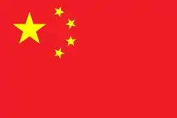 Yangzhou, Jiangsu, China
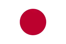 Tamba, Hyōgo Prefecture, Japan
 Sunnfjord, Norway
References
- Hunter, Steve (January 3, 2018). "Kent's new Mayor Ralph predicts 'great things' ahead". Kent Reporter. Retrieved June 15, 2019.
- "2019 U.S. Gazetteer Files". United States Census Bureau. Retrieved August 7, 2020.
- "U.S. Census website". United States Census Bureau. Retrieved December 19, 2012.
- "Annual Estimates of the Resident Population for Incorporated Places in Washington: April 1, 2010 to July 1, 2019". United States Census Bureau. May 2020. Retrieved May 27, 2020.
- "Kent". Geographic Names Information System. United States Geological Survey.
- "Kent is incorporated on May 28, 1890". historylink.org. History Ink. Retrieved July 29, 2015.
- "Annual Estimates of the Resident Population for Incorporated Places in Washington: April 1, 2010 to July 1, 2019". United States Census Bureau. May 2020. Retrieved May 26, 2020.
- "Quick Facts". United States Census Bureau. Retrieved November 15, 2019.
- Johnson, Florence K. Lentz ; pictorial research by Linda Van Nest ; "Partners in progress" by Lynn (1990). Kent—valley of opportunity : an illustrated history (1st ed.). Chatsworth, Calif.: Windsor Publications. p. 14. ISBN 0-89781-356-1.
- "Kent and the White River Valley Area". Washington Secretary of State. Washington Secretary of State. Retrieved September 18, 2017.
- "Kent and the White River Valley Area". Washington Secretary of State. Retrieved June 23, 2020.
- Johnson, Florence K. Lentz ; pictorial research by Linda Van Nest ; "Partners in progress" by Lynn (1990). Kent—valley of opportunity : an illustrated history (1st ed.). Chatsworth, Calif.: Windsor Publications. pp. 12, 17. ISBN 0-89781-356-1.
- Johnson, Florence K. Lentz ; pictorial research by Linda Van Nest ; "Partners in progress" by Lynn (1990). Kent—valley of opportunity : an illustrated history (1st ed.). Chatsworth, Calif.: Windsor Publications. p. 20. ISBN 0-89781-356-1.
- "Herefordshire Through Time - Welcome". Government of the United Kingdom. Retrieved July 12, 2011.
- Stein, Alan J. (September 24, 2001). "the Free Online Encyclopedia of Washington State History". HistoryLink.org. Retrieved July 12, 2011.
- Wilma, David (September 14, 1999). "the Free Online Encyclopedia of Washington State History". HistoryLink.org. Retrieved July 12, 2011.
- Lange, Greg (May 9, 1999). "the Free Online Encyclopedia of Washington State History". HistoryLink.org. Retrieved July 12, 2011.
- Long, Priscilla (August 6, 1999). "the Free Online Encyclopedia of Washington State History". HistoryLink.org. Retrieved July 12, 2011.
- "Archived copy". Archived from the original on September 23, 2006. Retrieved January 27, 2009.CS1 maint: archived copy as title (link)
- "Welcome to our Home Page". White River Valley Museum. Retrieved July 12, 2011.
- "History of Kent". kentwa.gov. Retrieved November 30, 2014.
- Long, Priscilla (September 4, 2006). "the Free Online Encyclopedia of Washington State History". HistoryLink.org. Retrieved July 12, 2011.
- "About | Greater Kent Historical Society Museum". Kent Historical Museum. Retrieved July 12, 2011.
- "History | Greater Kent Historical Society Museum". Kent Historical Museum. Retrieved July 12, 2011.
- "US Gazetteer files 2010". United States Census Bureau. Archived from the original on July 14, 2012. Retrieved December 19, 2012.
- ""Federal Way Link Extension"". Sound Transit. Retrieved November 15, 2019.
- "Parks, Trails & Open Space". Kent Washington Official Website. City of Kent, Washington. Retrieved April 20, 2013.
- "Monthly Averages for Seattle, WA". The Weather Channel. Archived from the original on July 10, 2014. Retrieved September 28, 2007.
- King County and Local Landmarks List, King County Preservation Program, Department of Natural Resources and Parks, August 2012, archived from the original on January 27, 2013, retrieved October 9, 2012
- Boyle, Alan. "Aerospace and Science Editor". GeekWire. GeekWire. Retrieved January 21, 2020.
- King County Elections
- "Kent Mayor Dana Ralph | City of Kent". www.kentwa.gov. Retrieved April 7, 2019.
- "Kent City Council – City of Kent". kentwa.gov. Retrieved June 15, 2019.
- "Convenience: a great selling point for GRCC". The Seattle Times.
- "Our School / Our School". kent.k12.wa.us. Retrieved May 19, 2014.
- "King County Annexation Initiative". Archived from the original on April 13, 2009.
- Kent Northeast annexation information – King County Official site
- "Annexation Frequently Asked Questions". City of Kent, Washington. Retrieved September 22, 2011.
- Hunter, Steve (May 17, 2018). "Kent street gets new name of Oberto Drive". Kent Reporter.
- "Work and Life in Balance!". kentwa.gov. City of Kent, Washington. Retrieved July 28, 2015.
- "Lunar Roving Vehicle". Boeing.
- "Facility Directory Listing". Mountain Hawk Corporation.
- "Kent Industrial Materials: Metals". Dex.
- "Salmon Bay Steel Corporation Factory, Kent, WA". University of Washington.
- "Welcome to Puget Sound Steel". Puget Sound Steel Co Inc.
- "Featured Project". Puget Sound Steel Co Inc.
- "Seattle". PACIFIC METAL COMPANY/Reliance Steel.
- "TMX Aerospace". ThyssenKrupp Materials NA, Inc.
- "About ThyssenKrupp Aerospace". ThyssenKrupp Aerospace.
- "Comprehensive Annual Financial Report 2018, City of Kent, Washington". City of Kent. July 1, 2019. p. 211. Retrieved July 6, 2020.
- "Census of Population and Housing". Census.gov. Retrieved June 4, 2016.
- "La tenue vestimentaire idéale pour faire du skate". 2012skateamerica.com. Archived from the original on July 21, 2013. Retrieved May 19, 2014.
- "Home – ISU". www2.isu.org. Archived from the original on June 1, 2012. Retrieved May 19, 2014.
- "La tenue vestimentaire idéale pour faire du skate". 2012skateamerica.com. Retrieved May 19, 2014.
- "Archived copy". Archived from the original on July 22, 2015. Retrieved June 12, 2015.CS1 maint: archived copy as title (link)
- "Gone forever: Golfers lament removal of Kent's Riverbend par 3 course – Kent Reporter". kentreporter.com. September 28, 2017. Retrieved March 21, 2018.
- "Seattle Thunderbirds". seattlesouthside.com.
- "image/5106f2716bb3f7e816000002-900-525/nfl-fans-map". Business Insider. Retrieved May 19, 2014.
- "A moment with ... Jeff Dye, comedian". Seattle Post-Intelligencer. July 30, 2008. Retrieved January 18, 2018.
- "Guide to the William M. Marutani Papers". Smithsonian Institution. Retrieved July 6, 2020.
- "Sister Cities, States, Counties & Ports". web.archive.org. Archived from the original on September 29, 2006. Retrieved May 20, 2014.
- "Sister Cities – City of Kent, Washington". kentwa.gov. Archived from the original on May 20, 2014. Retrieved May 19, 2014.
External links
| Wikimedia Commons has media related to Kent, Washington. |
Places adjacent to Kent, Washington | |
|---|---|
Municipalities and communities of King County, Washington, United States | ||
|---|---|---|
| Cities |
|  King County map |
| Towns | ||
| CDPs |
| |
| Unincorporated communities | ||
| Indian reservation | ||
| Ghost towns | ||
| Footnotes | ‡This populated place also has portions in an adjacent county or counties | |
| ||
Mayors of cities with populations exceeding 100,000 in Washington | ||
|---|---|---|
| ||
| Authority control |
|---|