1928 United States presidential election in Virginia
The 1928 United States presidential election in Virginia took place on November 6, 1928. Voters chose 12 representatives, or electors to the Electoral College, who voted for president and vice president.
| ||||||||||||||||||||||||||
| ||||||||||||||||||||||||||
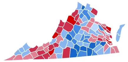 County Results
| ||||||||||||||||||||||||||
| ||||||||||||||||||||||||||
Virginia voted for the Republican nominee, former United States Secretary of Commerce Herbert Hoover, over the Democratic nominee, New York Governor Al Smith. Hoover ultimately carried the state with 53.91% of the vote. This was only the second election that Virginia had voted for a Republican candidate. The first was in 1872 during the Reconstruction era.
| Elections in Virginia |
|---|
 |
Results
| 1928 United States presidential election in Virginia[1] | |||||
|---|---|---|---|---|---|
| Party | Candidate | Votes | Percentage | Electoral votes | |
| Republican | Herbert Hoover | 164,609 | 53.91% | 12 | |
| Democratic | Al Smith | 140,146 | 45.90% | 0 | |
| Socialist | Norman Thomas | 250 | 0.08% | 0 | |
| Socialist Labor | Verne L. Reynolds | 180 | 0.06% | 0 | |
| Workers | William Z. Foster | 173 | 0.06% | 0 | |
| Totals | 305,358 | 100.00% | 12 | ||
Results by county
| County or Independent City | Herbert Clark Hoover Republican |
Alfred Emmanuel Smith Democratic |
Various candidates Other parties |
Margin | Total votes cast[2] | ||||
|---|---|---|---|---|---|---|---|---|---|
| # | % | # | % | # | % | # | % | ||
| Accomack County | 1,367 | 42.79% | 1,826 | 57.15% | 2 | 0.06% | -459 | -14.37% | 3,195 |
| Albemarle County | 846 | 34.97% | 1,571 | 64.94% | 2 | 0.08% | -725 | -29.97% | 2,419 |
| Alleghany County | 1,642 | 72.53% | 622 | 27.47% | 0 | 0.00% | 1,020 | 45.05% | 2,264 |
| Amelia County | 277 | 35.70% | 498 | 64.18% | 1 | 0.13% | -221 | -28.48% | 776 |
| Amherst County | 447 | 23.53% | 1,442 | 75.89% | 11 | 0.58% | -995 | -52.37% | 1,900 |
| Appomattox County | 446 | 33.43% | 885 | 66.34% | 3 | 0.22% | -439 | -32.91% | 1,334 |
| Arlington County | 4,274 | 74.41% | 1,444 | 25.14% | 26 | 0.45% | 2,830 | 49.27% | 5,744 |
| Augusta County | 2,679 | 63.82% | 1,507 | 35.90% | 12 | 0.29% | 1,172 | 27.92% | 4,198 |
| Bath County | 731 | 63.90% | 409 | 35.75% | 4 | 0.35% | 322 | 28.15% | 1,144 |
| Bedford County | 1,118 | 43.64% | 1,436 | 56.05% | 8 | 0.31% | -318 | -12.41% | 2,562 |
| Bland County | 826 | 58.92% | 575 | 41.01% | 1 | 0.07% | 251 | 17.90% | 1,402 |
| Botetourt County | 1,575 | 56.70% | 1,200 | 43.20% | 3 | 0.11% | 375 | 13.50% | 2,778 |
| Brunswick County | 245 | 20.98% | 922 | 78.94% | 1 | 0.09% | -677 | -57.96% | 1,168 |
| Buchanan County | 1,333 | 49.24% | 1,365 | 50.42% | 9 | 0.33% | -32 | -1.18% | 2,707 |
| Buckingham County | 579 | 49.15% | 599 | 50.85% | 0 | 0.00% | -20 | -1.70% | 1,178 |
| Campbell County | 801 | 45.10% | 967 | 54.45% | 8 | 0.45% | -166 | -9.35% | 1,776 |
| Caroline County | 638 | 49.84% | 639 | 49.92% | 3 | 0.23% | -1 | -0.08% | 1,280 |
| Carroll County | 2,459 | 68.51% | 1,117 | 31.12% | 13 | 0.36% | 1,342 | 37.39% | 3,589 |
| Charles City County | 207 | 66.35% | 105 | 33.65% | 0 | 0.00% | 102 | 32.69% | 312 |
| Charlotte County | 403 | 26.58% | 1,112 | 73.35% | 1 | 0.07% | -709 | -46.77% | 1,516 |
| Chesterfield County | 1,325 | 54.89% | 1,082 | 44.82% | 7 | 0.29% | 243 | 10.07% | 2,414 |
| Clarke County | 248 | 25.08% | 740 | 74.82% | 1 | 0.10% | -492 | -49.75% | 989 |
| Craig County | 451 | 47.88% | 489 | 51.91% | 2 | 0.21% | -38 | -4.03% | 942 |
| Culpeper County | 753 | 47.36% | 836 | 52.58% | 1 | 0.06% | -83 | -5.22% | 1,590 |
| Cumberland County | 213 | 32.32% | 442 | 67.07% | 4 | 0.61% | -229 | -34.75% | 659 |
| Dickenson County | 1,868 | 49.76% | 1,879 | 50.05% | 7 | 0.19% | -11 | -0.29% | 3,754 |
| Dinwiddie County | 332 | 25.94% | 945 | 73.83% | 3 | 0.23% | -613 | -47.89% | 1,280 |
| Elizabeth City County | 1,122 | 57.78% | 807 | 41.56% | 13 | 0.67% | 315 | 16.22% | 1,942 |
| Essex County | 195 | 37.79% | 321 | 62.21% | 0 | 0.00% | -126 | -24.42% | 516 |
| Fairfax County | 2,507 | 66.98% | 1,229 | 32.83% | 7 | 0.19% | 1,278 | 34.14% | 3,743 |
| Fauquier County | 972 | 38.79% | 1,531 | 61.09% | 3 | 0.12% | -559 | -22.31% | 2,506 |
| Floyd County | 1,481 | 77.34% | 433 | 22.61% | 1 | 0.05% | 1,048 | 54.73% | 1,915 |
| Fluvanna County | 327 | 42.03% | 447 | 57.46% | 4 | 0.51% | -120 | -15.42% | 778 |
| Franklin County | 1,529 | 45.05% | 1,861 | 54.83% | 4 | 0.12% | -332 | -9.78% | 3,394 |
| Frederick County | 1,006 | 46.77% | 1,140 | 53.00% | 5 | 0.23% | -134 | -6.23% | 2,151 |
| Giles County | 1,313 | 50.23% | 1,293 | 49.46% | 8 | 0.31% | 20 | 0.77% | 2,614 |
| Gloucester County | 614 | 51.12% | 587 | 48.88% | 0 | 0.00% | 27 | 2.25% | 1,201 |
| Goochland County | 318 | 42.18% | 431 | 57.16% | 5 | 0.66% | -113 | -14.99% | 754 |
| Grayson County | 2,728 | 61.25% | 1,713 | 38.46% | 13 | 0.29% | 1,015 | 22.79% | 4,454 |
| Greene County | 423 | 61.93% | 259 | 37.92% | 1 | 0.15% | 164 | 24.01% | 683 |
| Greensville County | 318 | 37.90% | 519 | 61.86% | 2 | 0.24% | -201 | -23.96% | 839 |
| Halifax County | 1,091 | 28.37% | 2,742 | 71.31% | 12 | 0.31% | -1,651 | -42.94% | 3,845 |
| Hanover County | 592 | 41.60% | 831 | 58.40% | 0 | 0.00% | -239 | -16.80% | 1,423 |
| Henrico County | 1,887 | 57.87% | 1,349 | 41.37% | 25 | 0.77% | 538 | 16.50% | 3,261 |
| Henry County | 1,139 | 47.28% | 1,267 | 52.59% | 3 | 0.12% | -128 | -5.31% | 2,409 |
| Highland County | 623 | 62.36% | 371 | 37.14% | 5 | 0.50% | 252 | 25.23% | 999 |
| Isle of Wight County | 555 | 51.10% | 531 | 48.90% | 0 | 0.00% | 24 | 2.21% | 1,086 |
| James City County | 204 | 50.12% | 201 | 49.39% | 2 | 0.49% | 3 | 0.74% | 407 |
| King and Queen County | 319 | 52.90% | 280 | 46.43% | 4 | 0.66% | 39 | 6.47% | 603 |
| King George County | 413 | 57.04% | 309 | 42.68% | 2 | 0.28% | 104 | 14.36% | 724 |
| King William County | 329 | 43.06% | 431 | 56.41% | 4 | 0.52% | -102 | -13.35% | 764 |
| Lancaster County | 520 | 62.28% | 315 | 37.72% | 0 | 0.00% | 205 | 24.55% | 835 |
| Lee County | 3,337 | 58.23% | 2,383 | 41.58% | 11 | 0.19% | 954 | 16.65% | 5,731 |
| Loudoun County | 1,325 | 40.84% | 1,915 | 59.03% | 4 | 0.12% | -590 | -18.19% | 3,244 |
| Louisa County | 772 | 51.23% | 734 | 48.71% | 1 | 0.07% | 38 | 2.52% | 1,507 |
| Lunenburg County | 314 | 20.75% | 1,199 | 79.25% | 0 | 0.00% | -885 | -58.49% | 1,513 |
| Madison County | 772 | 56.97% | 580 | 42.80% | 3 | 0.22% | 192 | 14.17% | 1,355 |
| Mathews County | 855 | 66.43% | 431 | 33.49% | 1 | 0.08% | 424 | 32.94% | 1,287 |
| Mecklenburg County | 784 | 30.90% | 1,752 | 69.06% | 1 | 0.04% | -968 | -38.16% | 2,537 |
| Middlesex County | 318 | 44.35% | 397 | 55.37% | 2 | 0.28% | -79 | -11.02% | 717 |
| Montgomery County | 1,861 | 65.64% | 967 | 34.11% | 7 | 0.25% | 894 | 31.53% | 2,835 |
| Nansemond County | 649 | 46.79% | 737 | 53.14% | 1 | 0.07% | -88 | -6.34% | 1,387 |
| Nelson County | 618 | 33.68% | 1,216 | 66.27% | 1 | 0.05% | -598 | -32.59% | 1,835 |
| New Kent County | 217 | 54.66% | 178 | 44.84% | 2 | 0.50% | 39 | 9.82% | 397 |
| Norfolk County | 1,922 | 57.39% | 1,418 | 42.34% | 9 | 0.27% | 504 | 15.05% | 3,349 |
| Northampton County | 688 | 42.39% | 935 | 57.61% | 0 | 0.00% | -247 | -15.22% | 1,623 |
| Northumberland County | 744 | 72.09% | 286 | 27.71% | 2 | 0.19% | 458 | 44.38% | 1,032 |
| Nottoway County | 667 | 40.33% | 986 | 59.61% | 1 | 0.06% | -319 | -19.29% | 1,654 |
| Orange County | 732 | 46.39% | 846 | 53.61% | 0 | 0.00% | -114 | -7.22% | 1,578 |
| Page County | 1,580 | 60.65% | 1,025 | 39.35% | 0 | 0.00% | 555 | 21.31% | 2,605 |
| Patrick County | 1,191 | 57.26% | 883 | 42.45% | 6 | 0.29% | 308 | 14.81% | 2,080 |
| Pittsylvania County | 2,598 | 60.52% | 1,688 | 39.32% | 7 | 0.16% | 910 | 21.20% | 4,293 |
| Powhatan County | 189 | 39.71% | 287 | 60.29% | 0 | 0.00% | -98 | -20.59% | 476 |
| Prince Edward County | 494 | 41.24% | 699 | 58.35% | 5 | 0.42% | -205 | -17.11% | 1,198 |
| Prince George County | 235 | 35.34% | 428 | 64.36% | 2 | 0.30% | -193 | -29.02% | 665 |
| Prince William County | 817 | 49.73% | 826 | 50.27% | 0 | 0.00% | -9 | -0.55% | 1,643 |
| Princess Anne County | 1,040 | 55.23% | 841 | 44.66% | 2 | 0.11% | 199 | 10.57% | 1,883 |
| Pulaski County | 1,998 | 52.32% | 1,821 | 47.68% | 0 | 0.00% | 177 | 4.63% | 3,819 |
| Rappahannock County | 329 | 39.07% | 513 | 60.93% | 0 | 0.00% | -184 | -21.85% | 842 |
| Richmond County | 467 | 61.53% | 292 | 38.47% | 0 | 0.00% | 175 | 23.06% | 759 |
| Roanoke County | 2,675 | 67.53% | 1,284 | 32.42% | 2 | 0.05% | 1,391 | 35.12% | 3,961 |
| Rockbridge County | 1,206 | 47.78% | 1,311 | 51.94% | 7 | 0.28% | -105 | -4.16% | 2,524 |
| Rockingham County | 3,822 | 73.06% | 1,402 | 26.80% | 7 | 0.13% | 2,420 | 46.26% | 5,231 |
| Russell County | 2,006 | 44.38% | 2,511 | 55.55% | 3 | 0.07% | -505 | -11.17% | 4,520 |
| Scott County | 2,916 | 55.28% | 2,355 | 44.64% | 4 | 0.08% | 561 | 10.64% | 5,275 |
| Shenandoah County | 3,420 | 68.01% | 1,589 | 31.60% | 20 | 0.40% | 1,831 | 36.41% | 5,029 |
| Smyth County | 2,751 | 58.53% | 1,937 | 41.21% | 12 | 0.26% | 814 | 17.32% | 4,700 |
| Southampton County | 648 | 43.40% | 844 | 56.53% | 1 | 0.07% | -196 | -13.13% | 1,493 |
| Spotsylvania County | 654 | 59.78% | 439 | 40.13% | 1 | 0.09% | 215 | 19.65% | 1,094 |
| Stafford County | 797 | 64.27% | 441 | 35.56% | 2 | 0.16% | 356 | 28.71% | 1,240 |
| Surry County | 157 | 22.43% | 541 | 77.29% | 2 | 0.29% | -384 | -54.86% | 700 |
| Sussex County | 385 | 41.31% | 547 | 58.69% | 0 | 0.00% | -162 | -17.38% | 932 |
| Tazewell County | 3,072 | 60.65% | 1,979 | 39.07% | 14 | 0.28% | 1,093 | 21.58% | 5,065 |
| Warren County | 564 | 44.20% | 710 | 55.64% | 2 | 0.16% | -146 | -11.44% | 1,276 |
| Warwick County | 465 | 60.78% | 298 | 38.95% | 2 | 0.26% | 167 | 21.83% | 765 |
| Washington County | 3,449 | 56.25% | 2,666 | 43.48% | 17 | 0.28% | 783 | 12.77% | 6,132 |
| Westmoreland County | 554 | 58.50% | 393 | 41.50% | 0 | 0.00% | 161 | 17.00% | 947 |
| Wise County | 4,504 | 49.63% | 4,559 | 50.24% | 12 | 0.13% | -55 | -0.61% | 9,075 |
| Wythe County | 2,540 | 62.56% | 1,516 | 37.34% | 4 | 0.10% | 1,024 | 25.22% | 4,060 |
| York County | 642 | 76.70% | 194 | 23.18% | 1 | 0.12% | 448 | 53.52% | 837 |
| Alexandria City | 1,617 | 55.26% | 1,307 | 44.67% | 2 | 0.07% | 310 | 10.59% | 2,926 |
| Bristol City | 630 | 40.49% | 922 | 59.25% | 4 | 0.26% | -292 | -18.77% | 1,556 |
| Buena Vista City | 267 | 60.68% | 172 | 39.09% | 1 | 0.23% | 95 | 21.59% | 440 |
| Charlottesville City | 708 | 41.57% | 992 | 58.25% | 3 | 0.18% | -284 | -16.68% | 1,703 |
| Clifton Forge City | 781 | 56.92% | 591 | 43.08% | 0 | 0.00% | 190 | 13.85% | 1,372 |
| Danville City | 2,360 | 66.27% | 1,196 | 33.59% | 5 | 0.14% | 1,164 | 32.69% | 3,561 |
| Fredericksburg City | 697 | 53.91% | 594 | 45.94% | 2 | 0.15% | 103 | 7.97% | 1,293 |
| Hampton City | 544 | 46.90% | 615 | 53.02% | 1 | 0.09% | -71 | -6.12% | 1,160 |
| Harrisonburg City | 1,037 | 62.66% | 616 | 37.22% | 2 | 0.12% | 421 | 25.44% | 1,655 |
| Hopewell City | 505 | 51.11% | 482 | 48.79% | 1 | 0.10% | 23 | 2.33% | 988 |
| Lynchburg City | 2,730 | 57.88% | 1,987 | 42.12% | 0 | 0.00% | 743 | 15.75% | 4,717 |
| Newport News City | 3,118 | 61.34% | 1,951 | 38.38% | 14 | 0.28% | 1,167 | 22.96% | 5,083 |
| Norfolk City | 8,392 | 58.65% | 5,888 | 41.15% | 29 | 0.20% | 2,504 | 17.50% | 14,309 |
| Petersburg City | 909 | 39.69% | 1,379 | 60.22% | 2 | 0.09% | -470 | -20.52% | 2,290 |
| Portsmouth City | 3,474 | 57.04% | 2,587 | 42.48% | 29 | 0.48% | 887 | 14.56% | 6,090 |
| Radford City | 524 | 58.29% | 373 | 41.49% | 2 | 0.22% | 151 | 16.80% | 899 |
| Richmond City | 10,767 | 51.20% | 10,213 | 48.57% | 49 | 0.23% | 554 | 2.63% | 21,029 |
| Roanoke City | 6,471 | 61.62% | 4,018 | 38.26% | 12 | 0.11% | 2,453 | 23.36% | 10,501 |
| South Norfolk City | 865 | 84.56% | 158 | 15.44% | 0 | 0.00% | 707 | 69.11% | 1,023 |
| Staunton City | 1,026 | 58.13% | 733 | 41.53% | 6 | 0.34% | 293 | 16.60% | 1,765 |
| Suffolk City | 573 | 47.28% | 637 | 52.56% | 2 | 0.17% | -64 | -5.28% | 1,212 |
| Williamsburg City | 98 | 24.02% | 310 | 75.98% | 0 | 0.00% | -212 | -51.96% | 408 |
| Winchester City | 1,168 | 59.35% | 794 | 40.35% | 6 | 0.30% | 374 | 19.00% | 1,968 |
| Totals | 164,609 | 53.91% | 140,146 | 45.89% | 609 | 0.20% | 24,463 | 8.01% | 305,364 |
References
- http://clerk.house.gov/member_info/electionInfo/1928election.pdf
- Robinson, Edgar Eugene; The Presidential Vote 1896-1932, pp. 354-361 ISBN 9780804716963
| |
|
This article is issued from Wikipedia. The text is licensed under Creative Commons - Attribution - Sharealike. Additional terms may apply for the media files.