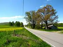
Coffee County, Tennessee
Coffee County is a county located in the central part of the state of Tennessee, in the United States. As of the 2010 census, the county's population was 52,796.[1] Its county seat is Manchester.[2]
Coffee County | |
|---|---|
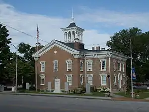 Coffee County Courthouse in Manchester | |
 Seal | |
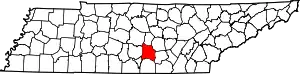 Location within the U.S. state of Tennessee | |
 Tennessee's location within the U.S. | |
| Coordinates: 35°29′N 86°04′W | |
| Country | |
| State | |
| Founded | January 8, 1836 |
| Named for | John Coffee |
| Seat | Manchester |
| Largest city | Tullahoma |
| Area | |
| • Total | 435 sq mi (1,130 km2) |
| • Land | 429 sq mi (1,110 km2) |
| • Water | 5.6 sq mi (15 km2) 1.3%% |
| Population | |
| • Estimate (2018) | 55,700 |
| • Density | 123/sq mi (47/km2) |
| Time zone | UTC−6 (Central) |
| • Summer (DST) | UTC−5 (CDT) |
| Congressional district | 6th |
| Website | coffeecountytn |
Coffee County is part of the Tullahoma-Manchester, TN Micropolitan Statistical Area. It is also part of Middle Tennessee, one of the three Grand Divisions of the state.
History
Coffee County was formed in 1836 from parts of Bedford, Warren, and Franklin counties.[3] It was named for John Coffee, a prominent planter, land speculator, and militia officer.[4][5] Similar to other counties in this area of the state, planters here cultivated mostly tobacco and hemp, produced by the labor of enslaved African Americans.
In the period after the Reconstruction era ended (1877) and into the early 20th century, whites in Coffee County committed eight lynchings of blacks. This was the fifth-highest total of any county in the state, but three other counties also had eight lynchings each.[6]
Century Farms
Coffee County has twelve Century Farms, the classification for farms that have been operating for more than 100 years. The oldest Century Farm is Shamrock Acres, founded in 1818. Other Century Farms include:[3]
- Beckman Farm
- Brown Dairy Farm
- Carden Ranch
- Crouch-Ramsey Farm
- Freeze Farm
- The Homestead Farm
- Jacobs Farm
- Long Farm
- Shamrock Acres
- Sunrise View Farm
- Thomas Farm, site of the Farrar Distillery
Geography
According to the U.S. Census Bureau, the county has a total area of 435 square miles (1,130 km2), of which 429 square miles (1,110 km2) is land and 5.6 square miles (15 km2) (1.3%) is water.[7]
Adjacent counties
- Cannon County (north)
- Warren County (northeast)
- Grundy County (east)
- Franklin County (south)
- Moore County (southwest)
- Bedford County (west)
- Rutherford County (northwest)
Major highways
- Interstate 24
- U.S. Route 41
- U.S. Route 41A
State protected areas
- Arnold Engineering Development Complex Wildlife Management Area (jointly managed by TWRA and USAF)
- Bark Camp Barrens Wildlife Management Area
- Hickory Flats Wildlife Management Area
- Maple Hill Wildlife Management Area
- May Prairie State Natural Area
- Normandy Wildlife Management Area (part)
- Old Stone Fort State Archaeological Park
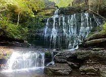
- Short Springs State Natural Area
Demographics
| Historical population | |||
|---|---|---|---|
| Census | Pop. | %± | |
| 1840 | 8,184 | — | |
| 1850 | 8,351 | 2.0% | |
| 1860 | 9,689 | 16.0% | |
| 1870 | 10,237 | 5.7% | |
| 1880 | 12,894 | 26.0% | |
| 1890 | 13,827 | 7.2% | |
| 1900 | 15,574 | 12.6% | |
| 1910 | 15,625 | 0.3% | |
| 1920 | 17,344 | 11.0% | |
| 1930 | 16,801 | −3.1% | |
| 1940 | 18,959 | 12.8% | |
| 1950 | 23,049 | 21.6% | |
| 1960 | 28,603 | 24.1% | |
| 1970 | 32,572 | 13.9% | |
| 1980 | 38,311 | 17.6% | |
| 1990 | 40,339 | 5.3% | |
| 2000 | 48,014 | 19.0% | |
| 2010 | 52,796 | 10.0% | |
| 2018 (est.) | 55,700 | [8] | 5.5% |
| U.S. Decennial Census[9] 1790-1960[10] 1900-1990[11] 1990-2000[12] 2010-2014[1] | |||
As of the census[14] of 2000, there were 48,014 people, 18,885 households, and 13,597 families residing in the county. The population density was 112 people per square mile (43/km2). There were 20,746 housing units at an average density of 48 per square mile (19/km2). The racial makeup of the county was 93.43% White, 3.59% Black or African American, 0.30% Native American, 0.74% Asian, 0.03% Pacific Islander, 0.91% from other races, and 1.00% from two or more races. 2.19% of the population were Hispanic or Latino of any race.
There were 18,885 households, out of which 32.40% had children under the age of 18 living with them, 56.90% were married couples living together, 11.10% had a female householder with no husband present, and 28.00% were non-families. 24.30% of all households were made up of individuals, and 10.30% had someone living alone who was 65 years of age or older. The average household size was 2.50 and the average family size was 2.96.
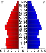
In the county, the population was spread out, with 25.10% under the age of 18, 8.30% from 18 to 24, 28.40% from 25 to 44, 23.60% from 45 to 64, and 14.60% who were 65 years of age or older. The median age was 38 years. For every 100 females, there were 95.10 males. For every 100 females age 18 and over, there were 92.30 males.
The median income for a household in the county was $34,898, and the median income for a family was $40,228. Males had a median income of $32,732 versus $21,014 for females. The per capita income for the county was $18,137. About 10.90% of families and 14.30% of the population were below the poverty line, including 17.80% of those under age 18 and 15.20% of those age 65 or over.
Events
The Bonnaroo Music Festival has been held annually in the county since 2002.[15]
Points of interest
- Arnold Engineering Development Complex
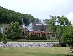
- George Dickel Tennessee whiskey distillery
- Old Stone Fort — part of Old Stone Fort State Archaeological Park, just west of Manchester
- Short Springs State Natural Area[16]
- Farrar Distillery – on the U.S. National Register of Historic Places
Communities
Census-designated places
Unincorporated communities
Politics
Coffee County is a Republican stronghold. The last Democrat to carry this county was Bill Clinton in 1996.
| Year | Republican | Democratic | Third Parties |
|---|---|---|---|
| 2020 | 73.6% 17,863 | 23.5% 5,704 | 2.9% 694 |
| 2016 | 72.2% 14,417 | 23.8% 4,743 | 4.1% 811 |
| 2012 | 67.6% 13,023 | 30.5% 5,870 | 1.9% 366 |
| 2008 | 63.7% 13,250 | 34.3% 7,132 | 2.0% 408 |
| 2004 | 58.5% 11,793 | 40.9% 8,243 | 0.7% 131 |
| 2000 | 49.4% 8,788 | 49.1% 8,741 | 1.5% 259 |
| 1996 | 43.2% 7,038 | 48.8% 7,951 | 8.1% 1,312 |
| 1992 | 35.5% 6,047 | 50.1% 8,534 | 14.5% 2,463 |
| 1988 | 57.6% 7,837 | 41.8% 5,686 | 0.7% 92 |
| 1984 | 57.1% 7,695 | 42.3% 5,691 | 0.6% 82 |
| 1980 | 40.7% 5,454 | 56.8% 7,612 | 2.4% 327 |
| 1976 | 32.1% 3,848 | 66.8% 8,017 | 1.2% 140 |
| 1972 | 66.2% 6,416 | 30.7% 2,973 | 3.2% 306 |
| 1968 | 29.9% 3,337 | 27.2% 3,040 | 42.9% 4,794 |
| 1964 | 30.6% 3,012 | 69.4% 6,837 | |
| 1960 | 39.8% 3,058 | 59.3% 4,555 | 1.0% 73 |
| 1956 | 32.4% 2,389 | 66.9% 4,930 | 0.7% 50 |
| 1952 | 37.3% 2,110 | 62.4% 3,537 | 0.3% 18 |
| 1948 | 16.6% 599 | 56.7% 2,041 | 26.7% 961 |
| 1944 | 17.4% 568 | 82.6% 2,703 | 0.1% 3 |
| 1940 | 15.6% 424 | 84.0% 2,277 | 0.4% 11 |
| 1936 | 15.9% 408 | 83.6% 2,148 | 0.5% 14 |
| 1932 | 17.9% 430 | 81.3% 1,950 | 0.8% 20 |
| 1928 | 48.7% 1,126 | 50.8% 1,175 | 0.4% 10 |
| 1924 | 21.8% 488 | 75.5% 1,691 | 2.7% 60 |
| 1920 | 28.7% 822 | 71.3% 2,043 | |
| 1916 | 20.8% 489 | 78.3% 1,837 | 0.9% 20 |
| 1912 | 22.5% 521 | 73.6% 1,705 | 3.9% 91 |
See also
References
- "State & County QuickFacts". United States Census Bureau. Archived from the original on July 8, 2011. Retrieved November 29, 2013.
- "Find a County". National Association of Counties. Archived from the original on 2011-05-31. Retrieved 2011-06-07.
- "Coffee County Century Farms". MTSU Center for Historic Preservation. Archived from the original on June 25, 2012. Retrieved December 22, 2012.
- Carroll Van West, "Coffee County," Tennessee Encyclopedia of History and Culture. Retrieved: 25 June 2013.
- Gannett, Henry (1905). The Origin of Certain Place Names in the United States. Govt. Print. Off. pp. 86.
- Lynching in America, Third Edition: Supplement by County Archived 2017-10-23 at the Wayback Machine, p. 9, Equal Justice Initiative, Mobile, AL, 2017
- "2010 Census Gazetteer Files". United States Census Bureau. August 22, 2012. Retrieved April 2, 2015.
- "Population and Housing Unit Estimates". Retrieved July 20, 2019.
- "U.S. Decennial Census". United States Census Bureau. Retrieved April 2, 2015.
- "Historical Census Browser". University of Virginia Library. Retrieved April 2, 2015.
- Forstall, Richard L., ed. (March 27, 1995). "Population of Counties by Decennial Census: 1900 to 1990". United States Census Bureau. Retrieved April 2, 2015.
- "Census 2000 PHC-T-4. Ranking Tables for Counties: 1990 and 2000" (PDF). United States Census Bureau. April 2, 2001. Retrieved April 2, 2015.
- Based on 2000 census data
- "U.S. Census website". United States Census Bureau. Retrieved 2011-05-14.
- "About Us". Bonnaroo Music Festival. Archived from the original on 2013-01-17.
- Short Springs State Natural Area, Tennessee Department of Environment and Conservation website. Retrieved: 25 June 2013.
- Leip, David. "Dave Leip's Atlas of U.S. Presidential Elections". uselectionatlas.org. Retrieved 2018-03-10.
External links
| Wikimedia Commons has media related to Coffee County, Tennessee. |
- Official site
- Industrial Board of Coffee County
- Coffee County Schools
- Coffee County, TNGenWeb – genealogy resources
- Bonnaroo Music Festival site
- Coffee County at Curlie
Places adjacent to Coffee County, Tennessee | ||||||||||
|---|---|---|---|---|---|---|---|---|---|---|
| ||||||||||
Municipalities and communities of Coffee County, Tennessee, United States | ||
|---|---|---|
| Cities | ||
| CDPs | ||
| Unincorporated communities | ||
| Footnotes | ‡This populated place also has portions in an adjacent county or counties | |
| ||

| Authority control |
|---|