Crockett County, Tennessee
Crockett County is a county located in the U.S. state of Tennessee. As of the 2010 census, the population was 14,586.[3] Its county seat is Alamo.[4]
Crockett County | |
|---|---|
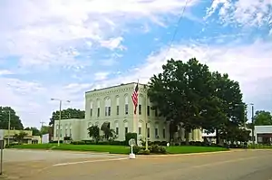 Crockett County Courthouse in Alamo | |
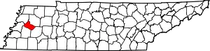 Location within the U.S. state of Tennessee | |
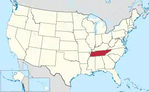 Tennessee's location within the U.S. | |
| Coordinates: 35°49′N 89°08′W | |
| Country | |
| State | |
| Founded | 1871 |
| Named for | Davy Crockett[1] |
| Seat | Alamo |
| Largest town | Alamo |
| Area | |
| • Total | 266 sq mi (690 km2) |
| • Land | 266 sq mi (690 km2) |
| • Water | 0.2 sq mi (0.5 km2) 0.08%% |
| Population | |
| • Estimate (2018) | 14,328[2] |
| • Density | 54/sq mi (21/km2) |
| Time zone | UTC−6 (Central) |
| • Summer (DST) | UTC−5 (CDT) |
| Congressional district | 8th |
Crockett County is included in the Jackson, TN Metropolitan Statistical Area.
History
Crockett County was formed in 1871 from portions of Haywood, Madison, Dyer and Gibson counties. It is named in honor of David Crockett (1786–1836), frontier humorist, soldier, Tennessee state legislator and U.S. congressman, and defender of the Alamo.[1][5]
In 1876, Crockett County Sheriff R. G. Harris and 19 other unidentified men removed four African Americans from the county jail and beat them, killing one of them. In United States v. Harris (1883), the Supreme Court ruled that the Sheriff could not be prosecuted under federal law.[6]
Geography
According to the U.S. Census Bureau, the county has a total area of 266 square miles (690 km2), of which 266 square miles (690 km2) is land and 0.2 square miles (0.52 km2) (0.08%) is water.[7]
Adjacent counties
- Gibson County (northeast)
- Madison County (southeast)
- Haywood County (south)
- Lauderdale County (west)
- Dyer County (northwest)
State protected areas
- Horns Bluff Refuge (part)
Demographics
| Historical population | |||
|---|---|---|---|
| Census | Pop. | %± | |
| 1880 | 14,109 | — | |
| 1890 | 15,146 | 7.3% | |
| 1900 | 15,867 | 4.8% | |
| 1910 | 16,076 | 1.3% | |
| 1920 | 17,438 | 8.5% | |
| 1930 | 17,359 | −0.5% | |
| 1940 | 17,330 | −0.2% | |
| 1950 | 16,624 | −4.1% | |
| 1960 | 14,594 | −12.2% | |
| 1970 | 14,402 | −1.3% | |
| 1980 | 14,941 | 3.7% | |
| 1990 | 13,378 | −10.5% | |
| 2000 | 14,532 | 8.6% | |
| 2010 | 14,586 | 0.4% | |
| 2018 (est.) | 14,328 | [8] | −1.8% |
| U.S. Decennial Census[9] 1790-1960[10] 1900-1990[11] 1990-2000[12] 2010-2014[3] | |||
As of the census[14] of 2000, there were 14,532 people, 5,632 households, and 4,066 families residing in the county. The population density was 55 people per square mile (21/km2). There were 6,138 housing units at an average density of 23 per square mile (9/km2). The racial makeup of the county was 81.96% White, 14.37% Black or African American, 0.20% Native American, 0.06% Asian, 2.79% from other races, and 0.63% from two or more races. 5.46% of the population were Hispanic or Latino of any race.
There were 5,632 households, out of which 32.70% had children under the age of 18 living with them, 56.40% were married couples living together, 11.80% had a female householder with no husband present, and 27.80% were non-families. 25.30% of all households were made up of individuals, and 11.50% had someone living alone who was 65 years of age or older. The average household size was 2.53 and the average family size was 3.01.
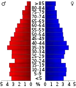
In the county, the population was spread out, with 25.10% under the age of 18, 8.10% from 18 to 24, 28.30% from 25 to 44, 22.70% from 45 to 64, and 15.80% who were 65 years of age or older. The median age was 37 years. For every 100 females there were 93.30 males. For every 100 females age 18 and over, there were 90.70 males.
The median income for a household in the county was $30,015, and the median income for a family was $36,713. Males had a median income of $27,436 versus $21,073 for females. The per capita income for the county was $14,600. About 13.20% of families and 16.90% of the population were below the poverty line, including 19.50% of those under age 18 and 17.90% of those age 65 or over.
Media
Radio
- WTJS Good News 93.1 - WTJS - Alamo - Southern Gospel Music
Newspaper
The Crockett Times is the paper of record in Crockett County, Tennessee. Locally owned and operated, The Times publishes articles on Crockett County communities of Alamo, Bells, Crockett Mills, Friendship, Gadsden and Maury City, as well as surrounding areas. The Times also publicizes legal notices such as notice to creditors, foreclosure notices, adoption notices, and beer permits. The newspaper is published once a week on Thursday. The Times began publishing in 1873 as the Crockett County Sentinel. In 1933, The Sentinel merged with two other newspapers and was renamed the Crockett Times.
Points of interest
Politics
| Year | Republican | Democratic | Third Parties |
|---|---|---|---|
| 2020 | 76.4% 4,673 | 22.6% 1,382 | 1.0% 59 |
| 2016 | 73.8% 3,982 | 24.1% 1,303 | 2.1% 112 |
| 2012 | 68.8% 3,783 | 30.4% 1,669 | 0.8% 46 |
| 2008 | 66.2% 3,994 | 32.6% 1,967 | 1.3% 76 |
| 2004 | 56.7% 3,242 | 43.0% 2,459 | 0.4% 21 |
| 2000 | 49.2% 2,676 | 49.7% 2,705 | 1.1% 59 |
| 1996 | 43.1% 1,872 | 52.0% 2,256 | 4.9% 214 |
| 1992 | 40.7% 2,180 | 49.6% 2,657 | 9.7% 520 |
| 1988 | 55.8% 2,214 | 43.9% 1,742 | 0.4% 14 |
| 1984 | 56.0% 2,479 | 43.7% 1,937 | 0.3% 13 |
| 1980 | 46.1% 2,117 | 52.8% 2,422 | 1.1% 49 |
| 1976 | 36.1% 1,694 | 63.1% 2,963 | 0.9% 40 |
| 1972 | 75.4% 2,642 | 21.0% 735 | 3.6% 127 |
| 1968 | 20.7% 932 | 15.6% 703 | 63.7% 2,865 |
| 1964 | 50.8% 1,873 | 49.2% 1,817 | |
| 1960 | 48.7% 1,467 | 47.7% 1,438 | 3.6% 108 |
| 1956 | 33.0% 1,026 | 63.2% 1,964 | 3.8% 117 |
| 1952 | 38.3% 1,343 | 61.4% 2,155 | 0.3% 11 |
| 1948 | 22.8% 601 | 53.6% 1,415 | 23.6% 624 |
| 1944 | 35.4% 782 | 64.2% 1,421 | 0.4% 9 |
| 1940 | 26.3% 733 | 73.4% 2,048 | 0.3% 9 |
| 1936 | 21.4% 525 | 78.4% 1,921 | 0.2% 4 |
| 1932 | 20.8% 513 | 78.4% 1,934 | 0.8% 20 |
| 1928 | 48.7% 710 | 51.3% 749 | |
| 1924 | 33.1% 587 | 65.8% 1,168 | 1.1% 20 |
| 1920 | 50.8% 2,326 | 49.2% 2,252 | |
| 1916 | 41.6% 1,144 | 58.4% 1,608 | |
| 1912 | 31.7% 852 | 48.3% 1,297 | 20.0% 536 |
From 1960 to 2000, Crockett was a swing county; since 2004 it has been trending increasingly Republican.
References
- Annie Laurie James, "Crockett County," Tennessee Encyclopedia of History and Culture. Retrieved: 25 June 2013.
- "Archived copy". Archived from the original on 2019-01-16. Retrieved 2018-05-07.CS1 maint: archived copy as title (link)
- "State & County QuickFacts". United States Census Bureau. Archived from the original on December 24, 2015. Retrieved November 29, 2013.
- "Find a County". National Association of Counties. Archived from the original on May 31, 2011. Retrieved 2011-06-07.
- Gannett, Henry (1905). The Origin of Certain Place Names in the United States. Govt. Print. Off. pp. 96.
- U.S. v. HARRIS, 106 U.S. 629 (1883), Findlaw.com. Retrieved: 25 June 2013.
- "2010 Census Gazetteer Files". United States Census Bureau. August 22, 2012. Retrieved April 2, 2015.
- "Population and Housing Unit Estimates". Retrieved July 20, 2019.
- "U.S. Decennial Census". United States Census Bureau. Retrieved April 2, 2015.
- "Historical Census Browser". University of Virginia Library. Retrieved April 2, 2015.
- Forstall, Richard L., ed. (March 27, 1995). "Population of Counties by Decennial Census: 1900 to 1990". United States Census Bureau. Retrieved April 2, 2015.
- "Census 2000 PHC-T-4. Ranking Tables for Counties: 1990 and 2000" (PDF). United States Census Bureau. April 2, 2001. Retrieved April 2, 2015.
- Based on 2000 census data
- "U.S. Census website". United States Census Bureau. Retrieved 2011-05-14.
- Leip, David. "Dave Leip's Atlas of U.S. Presidential Elections". uselectionatlas.org. Retrieved 2018-03-10.
External links
| Wikimedia Commons has media related to Crockett County, Tennessee. |
- The Crockett Reporter
- Crockett County Chamber of Commerce
- Crockett County Schools
- Crockett County, TNGenWeb – genealogy resources
- Crockett County at Curlie
Places adjacent to Crockett County, Tennessee | ||||||||||
|---|---|---|---|---|---|---|---|---|---|---|
| ||||||||||
Municipalities and communities of Crockett County, Tennessee, United States | ||
|---|---|---|
| Cities | ||
| Towns | ||
| Unincorporated communities | ||
| ||

| Authority control |
|---|