Henry County, Tennessee
Henry County is a county located on the northwestern border of the U.S. state of Tennessee, and is considered part of West Tennessee. As of the 2010 census, the population was 32,330.[2] Its county seat is Paris.[3] The county is named for the Virginia orator Patrick Henry.[4]
Henry County | |
|---|---|
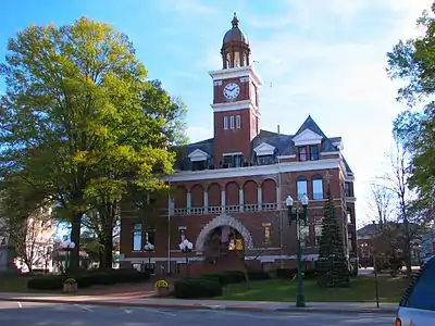 Henry County Courthouse in Paris | |
 Seal | |
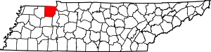 Location within the U.S. state of Tennessee | |
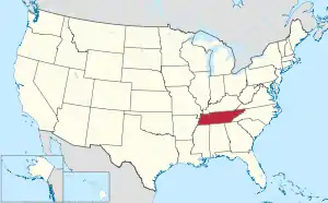 Tennessee's location within the U.S. | |
| Coordinates: 36°20′N 88°18′W | |
| Country | |
| State | |
| Founded | 1821 |
| Named for | Patrick Henry[1] |
| Seat | Paris |
| Largest city | Paris |
| Area | |
| • Total | 593 sq mi (1,540 km2) |
| • Land | 562 sq mi (1,460 km2) |
| • Water | 31 sq mi (80 km2) 5.3%% |
| Population | |
| • Estimate (2018) | 32,358 |
| • Density | 58/sq mi (22/km2) |
| Time zone | UTC−6 (Central) |
| • Summer (DST) | UTC−5 (CDT) |
| Congressional district | 8th |
| Website | henryco |
Henry County comprises the Paris, TN Micropolitan Statistical Area. West Tennessee lands and commodity culture were associated with the lowlands and delta of the Mississippi River, which created fertile areas that supported cotton culture. During the antebellum era, numerous enslaved African Americans provided labor for the cotton plantations.
Geography
According to the U.S. Census Bureau, the county has a total area of 593 square miles (1,540 km2), of which 562 square miles (1,460 km2) are land and 31 square miles (80 km2) (5.3%) are covered by water.[5]
Adjacent counties
- Calloway County, Kentucky (north)
- Stewart County (northeast)
- Benton County (southeast)
- Carroll County (south)
- Weakley County (west)
- Graves County, Kentucky (northwest)
National protected area
State protected areas
- Big Sandy Wildlife Management Area (part)
- Holly Fork Wildlife Management Area
- Paris Landing State Park
- West Sandy Wildlife Management Area
Demographics
| Historical population | |||
|---|---|---|---|
| Census | Pop. | %± | |
| 1830 | 12,249 | — | |
| 1840 | 14,906 | 21.7% | |
| 1850 | 18,233 | 22.3% | |
| 1860 | 19,133 | 4.9% | |
| 1870 | 20,380 | 6.5% | |
| 1880 | 22,142 | 8.6% | |
| 1890 | 21,070 | −4.8% | |
| 1900 | 24,208 | 14.9% | |
| 1910 | 25,434 | 5.1% | |
| 1920 | 27,151 | 6.8% | |
| 1930 | 26,432 | −2.6% | |
| 1940 | 25,877 | −2.1% | |
| 1950 | 23,828 | −7.9% | |
| 1960 | 22,275 | −6.5% | |
| 1970 | 23,749 | 6.6% | |
| 1980 | 28,656 | 20.7% | |
| 1990 | 27,888 | −2.7% | |
| 2000 | 31,115 | 11.6% | |
| 2010 | 32,330 | 3.9% | |
| 2018 (est.) | 32,358 | [6] | 0.1% |
| U.S. Decennial Census[7] 1790-1960[8] 1900-1990[9] 1990-2000[10] 2010-2014[2] | |||
As of the census[12] of 2000, 31,115 people, 13,019 households, and 9,009 families resided in the county. The population density was 55 people per square mile (21/km2). The 15,783 housing units averaged 28 per square mile (11/km2). The racial makeup of the county was 89.21% White, 8.96% African American, 0.19% Native American, 0.28% Asian, 0.03% Pacific Islander, 0.39% from other races, and 0.95% from two or more races. About 1.00% of the population was Hispanic or Latino of any race.
Of the 13,019 households, 27.50% had children under the age of 18 living with them, 54.40% were married couples living together, 11.20% had a female householder with no husband present, and 30.80% were not families. About 27.00% of all households were made up of individuals, and 12.80% had someone living alone who was 65 years of age or older. The average household size was 2.35 and the average family size was 2.82.
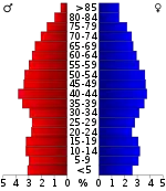
In the county, the population was distributed as 22.20% under the age of 18, 7.60% from 18 to 24, 26.30% from 25 to 44, 25.70% from 45 to 64, and 18.20% who were 65 years of age or older. The median age was 41 years. For every 100 females, there were 93.40 males. For every 100 females age 18 and over, there were 90.40 males.
The median income for a household in the county was $30,169, and for a family was $35,836. Males had a median income of $27,849 versus $20,695 for females. The per capita income for the county was $15,855. About 10.60% of families and 14.30% of the population were below the poverty line, including 20.10% of those under age 18 and 14.30% of those age 65 or over.
Media
Radio stations
- WMUF-FM 104.7 "Today's BEST Country"
- WRQR AM 1000 "The Best Classic Rock and Roll"
- FM 97.5 "Your Classic Hits"
- WLZK-FM 104.7 "The Lake - Powerhouse Adult Contemporary"
- WTPR-AM 710 "The Greatest Hits of All Time"
- WTPR-FM 101.7 "The Greatest Hits of All Time"
- WRQR-FM 105.5 "Today's Best Music with Ace & TJ in the Morning"
Communities
Cities
- McKenzie (mostly in Carroll County and a small portion in Weakley County)
- Paris (county seat)
- Puryear
Towns
Unincorporated communities
Politics
| Year | Republican | Democratic | Third Parties |
|---|---|---|---|
| 2020 | 74.7% 11,239 | 23.6% 3,548 | 1.7% 257 |
| 2016 | 73.5% 9,508 | 23.7% 3,063 | 2.9% 374 |
| 2012 | 64.3% 8,193 | 34.1% 4,339 | 1.6% 207 |
| 2008 | 60.4% 8,182 | 38.0% 5,153 | 1.6% 210 |
| 2004 | 55.7% 7,340 | 43.5% 5,732 | 0.8% 105 |
| 2000 | 48.3% 5,944 | 49.5% 6,093 | 2.2% 272 |
| 1996 | 37.1% 4,272 | 53.5% 6,153 | 9.4% 1,076 |
| 1992 | 30.3% 3,661 | 56.2% 6,797 | 13.5% 1,637 |
| 1988 | 48.0% 4,784 | 51.5% 5,138 | 0.5% 53 |
| 1984 | 49.6% 5,376 | 49.9% 5,407 | 0.5% 54 |
| 1980 | 38.5% 4,299 | 59.1% 6,601 | 2.4% 268 |
| 1976 | 26.2% 2,585 | 72.5% 7,162 | 1.4% 134 |
| 1972 | 60.6% 4,613 | 35.4% 2,694 | 4.0% 304 |
| 1968 | 23.9% 2,068 | 36.4% 3,149 | 39.7% 3,439 |
| 1964 | 27.8% 2,261 | 72.2% 5,874 | |
| 1960 | 36.9% 3,033 | 61.5% 5,049 | 1.6% 131 |
| 1956 | 29.0% 2,337 | 69.7% 5,625 | 1.3% 106 |
| 1952 | 29.8% 2,421 | 69.8% 5,677 | 0.4% 34 |
| 1948 | 14.1% 604 | 77.0% 3,292 | 8.9% 380 |
| 1944 | 18.3% 702 | 81.2% 3,111 | 0.5% 18 |
| 1940 | 14.5% 563 | 85.1% 3,307 | 0.4% 16 |
| 1936 | 12.6% 470 | 86.7% 3,223 | 0.7% 25 |
| 1932 | 10.5% 340 | 88.1% 2,867 | 1.5% 48 |
| 1928 | 28.0% 1,041 | 71.8% 2,667 | 0.1% 5 |
| 1924 | 17.6% 562 | 77.6% 2,478 | 4.8% 153 |
| 1920 | 29.5% 1,957 | 69.6% 4,613 | 1.0% 63 |
| 1916 | 31.3% 1,393 | 67.2% 2,988 | 1.5% 66 |
| 1912 | 24.4% 941 | 65.4% 2,526 | 10.2% 393 |
See also
References
- David Webb, "Henry County," Tennessee Encyclopedia of History and Culture. Retrieved: 17 October 2013.
- "State & County QuickFacts". United States Census Bureau. Archived from the original on June 7, 2011. Retrieved December 2, 2013.
- "Find a County". National Association of Counties. Archived from the original on 2011-05-31. Retrieved 2011-06-07.
- Gannett, Henry (1905). The Origin of Certain Place Names in the United States. Govt. Print. Off. pp. 155.
- "2010 Census Gazetteer Files". United States Census Bureau. August 22, 2012. Retrieved April 5, 2015.
- "Population and Housing Unit Estimates". Retrieved July 20, 2019.
- "U.S. Decennial Census". United States Census Bureau. Retrieved April 5, 2015.
- "Historical Census Browser". University of Virginia Library. Retrieved April 5, 2015.
- Forstall, Richard L., ed. (March 27, 1995). "Population of Counties by Decennial Census: 1900 to 1990". United States Census Bureau. Retrieved April 5, 2015.
- "Census 2000 PHC-T-4. Ranking Tables for Counties: 1990 and 2000" (PDF). United States Census Bureau. April 2, 2001. Retrieved April 5, 2015.
- Based on 2000 census data
- "U.S. Census website". United States Census Bureau. Retrieved 2011-05-14.
- Leip, David. "Dave Leip's Atlas of U.S. Presidential Elections". uselectionatlas.org. Retrieved 2018-03-10.
External links
| Wikimedia Commons has media related to Henry County, Tennessee. |
- Official site
- Henry County, TNGenWeb - free genealogy resources for the county
- Henry County at Curlie
Places adjacent to Henry County, Tennessee | ||||||||||
|---|---|---|---|---|---|---|---|---|---|---|
| ||||||||||
Municipalities and communities of Henry County, Tennessee, United States | ||
|---|---|---|
| Cities | Henry County map | |
| Towns | ||
| Unincorporated communities | ||
| Footnotes | ‡This populated place also has portions in an adjacent county or counties | |
| ||

| Authority control |
|---|
Sports
Lakewood Lady Eagles Basketball team,with a 4-9 winning and losing, they were able to compete in this years River Conference Championship and they came in 2nd with playing against Stewart County at the HCHS.On this years team the players were- Starting in 8th Grade Emma Atkins Paris Hale Katie Millard Allison Glatt
7th Grade Lauren Chandler Autumn Farris Aubrey Fortner Lilly Powell
6th Grade Irelyn Beecham Katilyn Farris Ava Rae Annie Grace Snow Peyton Wade