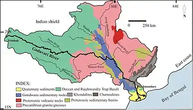
Pranhita River
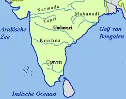
The Pranhita River is the largest tributary of Godavari River covering about 34%[4] of its drainage basin conveying the combined waters of the Penganga River, the Wardha River, and the Wainganga River. By virtue of its extensive network of tributaries, the river drains all of Vidarbha region in Maharashtra, as well as the southern slopes of the Satpura Ranges. It flows along the border of Gadchiroli district in Maharashtra and Adilabad district in Telangana. The Pranhita sub-basin is the seventh largest in India,[5] measuring about 109,078 km2, making it larger than the individual basins of significant rivers such as the Narmada River and Kaveri.
| pranahita | |
|---|---|
 | |
| Native name | प्राणहिता - ప్రాణహిత |
| Location | |
| Country | India |
| State | Maharashtra, Telangana |
| District | Gadchiroli, Adilabad |
| City | Sirpur |
| Physical characteristics | |
| Source | Confluence of Wardha and Wainganga |
| • location | Koutala,[1] Maharashtra, India |
| • coordinates | 19°35′24″N 79°47′59″E |
| • elevation | 146 m (479 ft) |
| Mouth | Godavari River |
• location | Kaleshwaram, Telangana |
• coordinates | 18°49′30″N 79°54′36″E |
• elevation | 107 m (351 ft) |
| Length | 113 km (70 mi) |
| Basin size | 109,078 km2 (42,115 sq mi) |
| Basin features | |
| Tributaries | |
| • left | Dina River[2] |
| • right | Nagulvagu River, Peddawagu River[3] |
Origin

The Pranhita River begins at the confluence of two extensive rivers: the Wardha (catchment area: 46,237 km2) and the Wainganga (catchment area: 49,677 km2). This junction lies on the border between the states of Maharashtra and Telangana near Kouthala (near Sirpur (T)). Right at the onset, the river enjoys a wide river bed.
Course
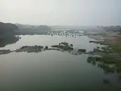
The Pranhita River follows a short course of 113 kilometers, strictly adhering to the boundary between Gadchiroli district in Maharashtra and Adilabad district in Telangana. The direction of flow is southward, unlike most rivers of the Deccan Plateau. Along its course, the river is flanked by thick forests and harbors a rich biodiversity of flora and fauna. After completing its short journey, the river empties itself into the Godavari River at Kaleswaram.
Dams
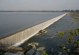
The Pranhita River currently does not have any dams built on it. However, a water project to construct a barrage is currently underway. This project, the Kaleshwaram lift irrigation project, has an estimated cost of Rs.38,500 crore and is a joint project between the Indian states of Maharashtra and Telangana.[6]
Uses
The River is used for water transport between Sironcha and Kaleswaram. It is also one of twelve rivers in the Pushkaram, a festival in Hindu traditions.
References
- "Villagers near Pranahita project the least informed". Thehindu.com. Retrieved 20 August 2017.
- "District Gadchiroli - Rivers & Dams". Gadchiroli.gov.in. Archived from the original on 20 August 2017. Retrieved 20 August 2017.
- "Archived copy". Archived from the original on 22 October 2015. Retrieved 12 October 2015.CS1 maint: archived copy as title (link)
- "Integrated Hydrological Databook (Non-Classified River Basins)" (PDF). Central Water Commission. March 2012. Archived from the original (PDF) on 4 March 2016. Retrieved 12 October 2015.
- "Archived copy". Archived from the original on 23 September 2015. Retrieved 12 October 2015.CS1 maint: archived copy as title (link)
- "Submergence, irrigation issues continue to dog Pranahita project". Thehindu.com. Retrieved 20 August 2017.