Chhindwara district
Chhindwara district is one of the major districts of Madhya Pradesh state of India, and Chhindwara town is the district headquarters. Chhindwara is the largest district in Madhya Pradesh with an area of 11,815 square km. The district is part of Jabalpur division.
Chhindwara district | |
|---|---|
District of Madhya Pradesh | |
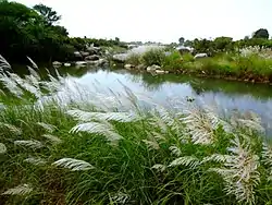 Kulebhra river near Chhindwara | |
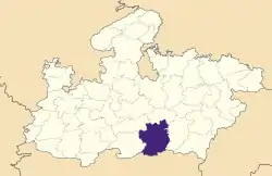 Location of Chhindwara district in Madhya Pradesh | |
| Country | India |
| State | Madhya Pradesh |
| Division | Jabalpur |
| Established | 1 November 1956[1] |
| Headquarters | Chhindwara |
| Tehsils | 11 |
| Government | |
| • Lok Sabha constituencies | Chhindwara |
| Area | |
| • Total | 11,815 km2 (4,562 sq mi) |
| Population (2011) | |
| • Total | 2,090,922 |
| • Density | 180/km2 (460/sq mi) |
| Demographics | |
| • Literacy | 72.21% |
| • Sex ratio | 966 |
| Time zone | UTC+05:30 (IST) |
| Major highways | 47, 347, 547 |
| Website | http://chhindwara.nic.in |
General information
The name Chhindwara has been derived from the word 'Chhind' which basically is a name of a local tall tree surrounding the district.
Chhindwara District ranks first in area (11,815 km²) in Madhya Pradesh State and occupies 3.85% of the area of the state. Chhindwara district was formed on 1 November 1956.[1]
It is on the southwest region of 'Satpura Range of Mountains'.[1] It is spread from 21.28 to 22.49 deg. North (latitude) and 78.40 to 79.24 deg. East (longitude) and spread over an area of 11,815 km². This district is bound by the plains of Nagpur district (in Maharashtra State) on the south, Hoshangabad and Narsinghpur districts on the north, Betul district on the west and Seoni district on the east.[1]
Divisions
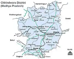
The district is divided into 13 tehsils:[2]
- Amarwara
- Bichhua
- Chand
- Chourai
- Harrai
- Junnardeo
- Mohkhed
- Pandhurna
- Parasia
- Sausar
- Tamia
- Umreth
- Chhindwara
and 11 Development Blocks: Chhindwara, Parasia, Junnardeo, Damua, Tamia, Amarwara, Chourai, Bichhua, Harrai, Mohkhed, Sausar and Pandhurna. There is one Nagar Nigam (chhindwara) There are 8 Nagar Palikas (Parasia, Junnardeo, Damua and Bichhua, Pandhurna Sausar, Amarwara, Chourai), 9 Nagar Panchayats (Chandameta Butaria, Newton Chiklis, Chand, Harrai, Mohgaon, Chourai, Bichhua, Lodhikheda and Pipla Narayanwar). Apart from this there are eleven small towns (Umranala, Dighawani, Jatachapar, Iklehara, Pagara, Kalichapar, Damua, Pala Chourai, Bhamori, Ambada and Badkuhi).
Demographics
| Year | Pop. | ±% p.a. |
|---|---|---|
| 1901 | 407,999 | — |
| 1911 | 517,109 | +2.40% |
| 1921 | 491,835 | −0.50% |
| 1931 | 573,272 | +1.54% |
| 1941 | 610,707 | +0.63% |
| 1951 | 646,430 | +0.57% |
| 1961 | 785,535 | +1.97% |
| 1971 | 989,413 | +2.33% |
| 1981 | 1,233,131 | +2.23% |
| 1991 | 1,568,702 | +2.44% |
| 2001 | 1,849,283 | +1.66% |
| 2011 | 2,090,922 | +1.24% |
| source:[3] | ||
According to the 2011 census Chhindwara District has a population of 2,090,922,[4] This gives it a ranking of 218th in India (out of a total of 640).[4] The district has a population density of 177 inhabitants per square kilometre (460/sq mi).[4] Its population growth rate over the decade 2001-2011 was 13.03%.[4] Chhindwara has a sex ratio of 966 females for every 1000 males,[4] and a literacy rate of 72.21%. Scheduled Castes and Scheduled Tribes made up 11.1% and 36.8% of the population respectively.[4]
There are 1,984 villages in the district, out of which 1,903 villages are inhabited. It is divided into 19 Revenue Circles, 319 Patwari Halkas. There are 808 Panchayats in the district. Chhindwara is the Parliamentary Constituency in the district and there are eight assembly segments (Jamai, Chhindwara, Parasia, Damua, Amarwara, Chourai, Sausar and Pandhurna). As per Census 2001 the population of Chhindwara town was 1,22,309 and of the district is 18,48,882 with a population density of 156 people per km². There are 953 females for every 1000 males.
The sex ratio of rural Chhindwara is more (962) than that of urban Chhindwara (926). As per Census 2001, the average literacy rate of the district was 66.03%, which is above the average of the MP state's 64.08%. The literacy rate in the rural area of the district is 60.76% and that of urban area is 81.46%.
Languages
At the time of the 2011 Census of India, 81.62% of the population in the district spoke Hindi, 10.32% Marathi, 5.52% Gondi and 1.75% Korku as their first language.[5]
Residents speak multiple languages, including Bagheli, which has a lexical similarity of 72%-91% with Hindi[6] (compared to 60% for German and English),[7] and is spoken by about 7,800,000 people in Bagelkhand;[6] and Bharia, a Dravidian language spoken by at least 200,000 members of the Bharia tribe and written in the Devanagari script.[8] Marathi is spoken in the regions of Pandhurna and Sausar. Marathi language is spoken by at least 65% population in Chhindwara district this language group has a dominating population. There are several known Maharashtra mandals that keep Marathis connected throughout.
Geography
Geographically, Chhindwara district can be divided into three main regions:
- the western region consists two major towns: Junnardeo and Parasia;
- the central region consists of Chhindwara, southern part of Amarwara region, and northern part of Sausar region; it is also known as the Satpura mountain region;
- The third region is mostly the northern region consisting of hilly terrain.
The altitude of the district varies from 1,550 ft (470 m) to 3,820 ft (1,160 m) above sea level with an average elevation of 2215 feet (675 m).
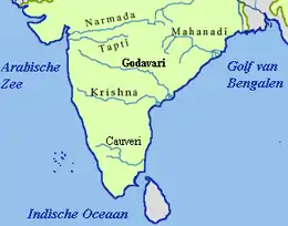
There are five major rivers which flow through the district — the Kanhan, the Pench, the Jam, the Kulbehra, the Shakkar and the Doodh.
The Kanhan River flows in a southern direction through the western parts of Chhindwara Tehsil and enters the Wenganga River. The Jam River flows mostly through the Sausar region and joins with the Kanhan River. The Pench River flows in the border areas of Chhindwara and Seoni districts and mixes with the Kanhan River in Nagpur District. The Kulbehra River starts at Umreth and flows through Chhindwara and Mohkhed and joins with Pench River.
Around 4212.556 km² of the district is covered under forest. Bamboo, teak, harra, saalbeej, and tendu patta are the major commercially harvested trees.
Climate
Chhindwara has a subtropical climate bordering tropical wet and dry climate. Like most of north India it has a hot, dry summer (April–June) followed by monsoon rains (July–September), and a cool and relatively dry winter. Average annual rainfall is 1,183 mm. Minimum temperature during winter is 4 to 6 degrees Celsius while maximum temperature during summer is 38 to 42 degrees Celsius.
History
In Chhindwara the Gauli Rule existed before the advent of the Gonds. Deogarh on the Chhindwara plateau is believed to be the last seat of Gauli power. According to legend, founder of the Gond dynasty, Jatha slew and supplanted the Gauli chiefs Ransur and Ghamsur.[9]
History records the place from the time of the rule of King Bakht Bulund, whose kingdom was spread over the Satpura range of hills and it is believed that his rule was up to the 3rd century. One ancient plaque, belonging to Rashtrakut dynasty, was found in Neelkanth village. This dynasty ruled up to the 7th century. Then came the Gondwana dynasty which ruled the area with Deogarh as the capital. King Bakht Bulund was most powerful in the dynasty and he has adopted Islam as his religion during the rule of Emperor Aurangzeb. Power changed many hands and Maratha rule ended in 1803.
On 17 September 1803, the British East India Company had taken over this kingdom by defeating Raghoji II Bhonsle, starting the British rule. Chhindwara district had been part of the Nerbudda (Narmada) Division of the Central Provinces and Berar, which became the state of Madhya Bharat (later Madhya Pradesh) after India's independence in 1947.[10] After Independence, Nagpur was made the capital of Chhindwara District, and on 1 November 1956 this district was re-constituted with Chhindwara as the capital.
Media
Newspapers: Chhindwara has a few print publications which include Hindi newspapers such as, Dainik Bhaskar, Lokmat Samachar, Patrika, Divya Express and a recent web publication called news4india.
Educational Institutions
Colleges
Some colleges -
- Government Anonymous PG College, Chhindwara
- Shri Shri Laxmi Narayan Government Pench Valley PG College, Parasia, District - Chhindwara
- Government Polytechnic College, Khirsadoh, District - Chhindwara
Schools
Some schools -
- Government Adarsh Multipurpose School of Excellence, Chhindwara
- Shri Nandlal Sood Government School of Excellence, Junnardeo, District - Chhindwara
- Jawahar Navodaya Vidyalaya Singori, Chhindwara
- Kendriya Vidyalaya (Chhindwara, Junnardeo, Barkuhi)
- Kanhan Valley School Dungariya, District - Chhindwara
Other Institutes
Some other institutions -
- Government Industrial Training Institute, Chhindwara (NCVT)
- Government Industrial Training Institute, Junnardeo, District - Chhindwara (SCVT)
Industries
Following are few recognizable industries that have contributed to the industrial development of Chhindwara:
Hindustan Unilever Limited is a multinational company, originally from England. Earlier this company's name was Hindustan Lever Limited. Chhindwara Hindustan Unilever Limited is in village Lahgadua, 5 km from Chhindwara. This company completed 75 years in 2008. There are 210 workers in Hindustan Unilever, who work in three shifts. The Chhindwara factory produces three main products: Rin washing soap, Wheel washing powder, and Surf Excel washing powder. It is the only factory of Hindustan Unilever in Madhya Pradesh. In 2007 the production was 70,000 units.
The Raymond Chhindwara plant, set up in 1991, is a state-of-the-art integrated manufacturing facility located 65 km from Chhindwara. Built on 100 acres (0.40 km2) of land, the plant produces premium pure wool, wool blend, and polyester viscose suiting. This plant has achieved a record production capacity of 14.65 million meters, giving it the distinction of being the single largest integrated worsted suiting unit in the world.
Spices Park:—
India's first spice park was opened in Chhindwara on 25 February 2009. The first in a series of seven parks planned by the Spices Board is being set up with an investment of Rs 20 cr. The initial phase of the park consists of a Garlic Dehydration Plant set up by the Spices Board and a Steam Sterilization Unit set up by STCL Ltd., a public sector company. KITCO are the technical consultants for the project. The park has come up in an area of 18 acres (73,000 m2) in Laas village, Umranala, near Chhindwara in Madhya Pradesh on Chhindwara-Nagpur Highway.
Nakoda Group:—
This group is Medium scale and fast growing industrial group of Chhindwara. Unit exist in Borgaon Industrial Area near Raymond Group. Leaded By Mr. Mayank Kothari and Mr. Ritesh Jain this group is expanding and raising job opportunity for local public and have given job to more than 200 People in last 3 years.
Amongst other large scale industries are Super Pack (Bajaj) at Village Sawli near Sausar, Bhansali Engineering Polymers at village Satnur near Sausar, P.B.M. Polytex Ltd. at village Borgaon near Sausar and Suryawanshi Spinning Mills at village Rajna near Pandhurna.
Coal mines
Junnardeo, about 50 km from Chhindwara, is the head office of the Kanhan area of WCL. It has Asia's largest coal wash plant. It has around 15 coal mines in the Kanhan area. It has a big railway coal transportation and its own importance in railways.
Parasia, about 30 km from Chhindwara, is known as the "Coal Mines Belt". There were 24 mines in this area, of which 20 mines are still working. The principal mines are Eklehara Mines, Barkuhi Mines, Chandameta Mines, Newton Mines, Donger Chikhali Mines, Mahadev Puri Mines. Ravanwara Mines, Ravanwara Khash, Vishnu Puri 11 No., Vishnu Puri 12 No., Chhinda Mines, Setiya Mines, Shivpuri Mines, Shivpuri Mines, Chhury Mines, Mathani Mines, Thisgora Mines, Nahariya Mines, Pench Mines, and Urdhan Project.
Tourism
Following Prominent Tourist Spots in the District. The unique fair of stone Gotmaar mela of Pandhurna is also attractive for the tourist all around the world.
- Kukdikhapa Waterfall
- Lilhi Waterfall
- Patalkot (Valley)
- Tamia Hills
- Junnardeo Hills
- Junnardeo Pahali Payari (Siddh Peeth)
- Sri Sri Hinglaj Devi Mandir, Ambada (Shakti Peeth)
- Chhota Mahadev Caves
- Deogarh Fort, District - Chhindwara
- Harrai Tribal Museum
- Jam Sawli Hanuman Mandir
- Ardhnarishwar Jyotirlinga, Mohgaon Haveli
- Shashthi Mata Mandir, Kapurda
- Banjari Mata Mandir
- Girja Maai Mandir, Tamia
- Khedapati Mata Mandir, Chandameta
- Mandir-Masjid, Eklehra
- Chandshah Vali Dargah
- Pandhurna Gotmaar Mela (Fair)
- Kaliraat Mela (Fair)
- Raini Dham / Meghnath Dham (7days Fair)
- Anhoni Hot Water Spring
- Sillewani Valley
- Jilhari Ghat, District - Chhindwara
- Lodheshwar Mahadev Mandir, Damua
- Maa Kali Chausath Yogini Mandir, Dungariya
Railway Station's
Major railways station's in Chhindwara District :
- Chhindwara Junction
- Parasia
- Junnardeo
- Nawegaon
- Khirsadoh
- Gangiwara
- Sausar
- Bhandarkund
- Umranala
- Lodhikheda
- Bhimalgondi
- Pandhurna
- Teegaon
- Jhilmili
- Chourai
Development
Chhindwara is an underconstructed and clean and green district .
Pataleshwara
Pataleshwara is a famous temple in Chhindwara. This is a Lord Shiva temple where the Shivratri Mela is held. In Chhindwara a shivling find out in "Ground".this shivling was seen before 250 years . In the bavari (step well) some ashes of mahatma gandhi were thrown this temple also have many small temples of lord bhairava, hanumana, goddess kali and many shivlings
Pench National Park
The Pench National Park or Pench Tiger Reserve is named after the Pench River, which flows from north to south through the reserve in the southern reaches of the Satpura hill ranges in the Seoni and Chhindwara districts of Madhya Pradesh. The terrain is undulating, with most of the area covered by small hill ranges, steeply sloping on the sides. The reserve is in an area that holds a significant place in the natural history of Central India.
The description of its landscape, flora, and fauna has appeared in wildlife books dating back to the 17th century. Books written in the 19th and early 20th century by naturalists such as Captain J. Forsyth and Rudyard Kipling's Jungle Book explicitly present a detailed panorama of this tract.
References
- MSME-Development Institute. "Brief Industrial Profile of Chindwara District, Madhya Pradesh" (PDF). Ministry of Micro, Small and Medium Enterprises (MSME), Government of India. Archived (PDF) from the original on 24 January 2013.
- "District Profile: Chhindwara" (PDF). District Administration Chhindwara. 29 May 2012. Archived from the original (PDF) on 14 November 2012. Retrieved 18 April 2015.
- Decadal Variation In Population Since 1901
- "District Census 2011". Census2011.co.in. 2011. Retrieved 30 September 2011.
- 2011 Census of India, Population By Mother Tongue
- M. Paul Lewis, ed. (2009). "Bagheli: A language of India". Ethnologue: Languages of the World (16th ed.). Dallas, Texas: SIL International. Retrieved 28 September 2011.
- M. Paul Lewis, ed. (2009). "English". Ethnologue: Languages of the World (16th ed.). Dallas, Texas: SIL International. Retrieved 28 September 2011.
- M. Paul Lewis, ed. (2009). "Bharia: A language of India". Ethnologue: Languages of the World (16th ed.). Dallas, Texas: SIL International. Retrieved 28 September 2011.
- B.H. Mehta (1984). Gonds of the Central Indian Highlands Vol II. Concept Publishing Company. p. 571.
- Hunter, William Wilson, Sir, et al. (1908). Imperial Gazetteer of India, Volume 6. 1908-1931; Clarendon Press, Oxford
External links
| Wikimedia Commons has media related to Chhindwara district. |
- Chhindwara City
- Chhindwara District
- . Encyclopædia Britannica. 6 (11th ed.). 1911. pp. 116–117.
Places adjacent to Chhindwara district | |
|---|---|
| State symbols | |
|---|---|
| Topics | |
| Governance |
|
| Divisions | |
| Districts |
|
| Major cities | |