Seoni district
Seoni District is a district of Madhya Pradesh state in central India. The town of Seoni is the district headquarters.
Seoni district | |
|---|---|
District of Madhya Pradesh | |
 | |
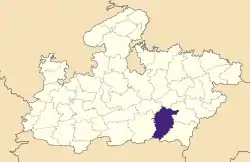 Location of Seoni district in Madhya Pradesh | |
| Country | India |
| State | Madhya Pradesh |
| Division | Jabalpur |
| Headquarters | Seoni (Madhya Pradesh) |
| Government | |
| • Lok Sabha constituencies | Balaghat |
| Area | |
| • Total | 8,758 km2 (3,381 sq mi) |
| Population (2011) | |
| • Total | 1,379,131 |
| • Density | 160/km2 (410/sq mi) |
| Demographics | |
| • Literacy | 91.16 per cent |
| • Sex ratio | 984 |
| Time zone | UTC+05:30 (IST) |
| Average annual precipitation | 1384 mm |
| Website | http://seoni.nic.in |
Geography
Seoni district forms part of the Satpura tableland. It is largely covered with forest. The district is remarkable for the beauty of its scenery and the fertility of its valleys.[1]
The northern and western portions include the plateaus of Lakhnadon and Seoni; the eastern section consists of the watershed and elevated basin of the Wainganga; and in the south-west is a narrow strip of rocky land known as Dongartal. The plateaus of Seoni and Lakhnadon vary in height from 1,800 to 2,000 ft.; they are well cultivated and clear of jungle, and their temperature is always moderate and healthy.[1]
Geologically the north part of Seoni consists of trap hills and the south of crystalline rock. The soil of the plateaus is the rich black cotton soil formed by disintegrated trap, of which about two-thirds of the district are said to consist; but towards the south, where cliffs of gneiss and other primitive formations occur, the soil is siliceous and contains a large proportion of clay.[1]
The chief river is the Wainganga, with its affluents the Sagar, Theli, Bijna and Thanwar; other streams are the Timar and the Sher, tributaries of the Nerbudda. The annual rainfall averages 53 in. The principal crops are wheat, millets, rice, pulse, oil-seeds and cotton.[1] [[this reference from 117 years ago (!) is not current. Crops grown in Seoni today on more than 30,000 ha are (in descending order) rice, wheat, maize, chickpea (gram), and soybean—data available from Indian gov't at https://eands.dacnet.nic.in/Default.htm]]
It extends over an area of 8,758 km2.[2]
History
The district was formed on 1 November 1956. The name of the district originated from the word Seona (Gudina arborea), a species of tree commonly found in the area.[2]
Economy
In 2006 the Ministry of Panchayati Raj named Seoni one of the country's 250 most backward districts (out of a total of 640).[3] It is one of the 24 districts in Madhya Pradesh currently receiving funds from the Backward Regions Grant Fund Programme (BRGF).[3]
Demographics
| Year | Pop. | ±% p.a. |
|---|---|---|
| 1901 | 328,281 | — |
| 1911 | 396,165 | +1.90% |
| 1921 | 348,871 | −1.26% |
| 1931 | 393,732 | +1.22% |
| 1941 | 423,333 | +0.73% |
| 1951 | 434,061 | +0.25% |
| 1961 | 523,741 | +1.90% |
| 1971 | 668,352 | +2.47% |
| 1981 | 809,713 | +1.94% |
| 1991 | 1,000,831 | +2.14% |
| 2001 | 1,166,608 | +1.54% |
| 2011 | 1,379,131 | +1.69% |
| source:[4] | ||
According to the 2011 census Seoni District has a population of 1,379,131,[5] roughly equal to the nation of Swaziland[6] or the US state of Hawaii.[7] This gives it a ranking of 355th in India (out of a total of 640).[5] The district has a population density of 157 inhabitants per square kilometre (410/sq mi).[5] Its population growth rate over the decade 2001-2011 was 18.2%.[5] Seoni has a sex ratio of 984 females for every 1000 males,[5] and a literacy rate of 73.01%. Scheduled Castes and Scheduled Tribes made up 9.5% and 37.7% of the population respectively.[5]
At the time of the 2011 Census of India, 89.66% of the population in the district spoke Hindi, 6.91% Gondi, 1.77% Marathi and 1.36% Urdu as their first language.[8]
As per 2001 census, Seoni district had a total population of 1,165,893, out of which 588,135 were males and 577,758 were females. During the decade 1991-2001 population growth rate was 16.49 per cent. Sex ratio was 982. Density of population was 133 / km2.[9]
Scheduled tribes constitute over 36 per cent of the population in the district.[2] Gonds have a major concentration in Seoni district.[10] sanodiya (kurmi) are the major residents of the district. They occupy about 250 villages of the district.
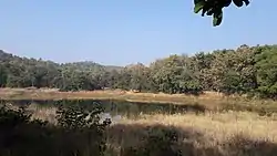
Pench Tiger Reserve
The River Bainganga's source is located beneath the village Mundara, where it includes for example the Pench Tiger Reserve within 10 km. The Pench Tiger Reserve is named after the Pench River, which flows from north to south through the reserve, and is located in the southern reaches of the Satpura hill ranges in the Seoni and Chhindwara districts in the Madhya Pradesh state of India. The terrain is undulating, with most of the area covered by small hill ranges, steeply sloping on the sides. The Pench National Park is named after the Pench River, which flows from north to south through the park. This river constitutes the district boundary of Seoni and Chhindwara districts of Madhya Pradesh in the upper region and State boundary with Maharashtra State in the lower region. This area became the 19th tiger reserve of India in 1992. The tourist traffic is experiencing fast growth in this park. The Pench National Park which constitutes the core of the tiger reserves was notified in the year 1983. The total area of the park is 292.85 km2. The total area of the Pench Tiger Reserve is 757.85 km2.
The reserve is situated in an area that holds a significant place in the natural history of Central India. Descriptions of its flora and fauna have appeared in wildlife books dating back to the 17th century. Books written in the 19th and early 20th century by naturalists like Captain J. Forsyth and Rudyard Kipling's Jungle Book cover the panorama of nature's abundance in this tract.
A forest belt extends in three directions: north, east and south, covering forest tracts of Seoni, Balaghat and Nagpur districts. The contiguous forest on the southern side in the Maharashtra state of India, initially named Pandit Jawaharlal Nehru National Park has been recently included in the Project Tiger network under the same name as this reserve. A dam was constructed on the Pench River on south-eastern boundary of the reserve.
The area is criss-crossed by numerous seasonal streams and "nalas". The Pench River flowing through the central line of the reserve is dry by the end of April but a number of water pools locally known locally as "dohs" are found, which serve as waterholes for wild animals. A few perennial springs also exist in this area. However, the water sources are not suitably distributed, hence large area remains unused by the wild animals. The Pench reservoir at the center of the reserve is the only major water source during pinch period.
As the prey concentration is high along the Pench River, tigers usually inhabit this belt. Leopards, though, generally operate in the peripheral areas but are occasionally seen in deep forests also. Jungle cats are commonly seen. Leopard cats, small Indian civet and palm civet are common but seen very rarely.
Wild dogs are commonly seen in packs of 12 to 15, near Chhedia, Jamtara, Bodanala and Pyorthadi areas of the reserve. Wild boars are ubiquitous. Sloth bears occupy the hilly, rocky outcrops and favour mahul bel-infested forest. Chinkara are present in very small numbers and are found in open areas around Turia, Telia, and Dudhgaon villages. Jackals are seen occasionally near Tekadi, Alikatta and Chhindimatta villages.
Culture
Rudyard Kipling's Jungle Books are set in the Seoni District (spelled Seeonee in the books).
References
-
 One or more of the preceding sentences incorporates text from a publication now in the public domain: Chisholm, Hugh, ed. (1911). "Seoni". Encyclopædia Britannica. 24 (11th ed.). Cambridge University Press. p. 651.
 - "Seoni, Madhya Pradesh". District administration. Retrieved 2010-08-19.
- Ministry of Panchayati Raj (September 8, 2009). "A Note on the Backward Regions Grant Fund Programme" (PDF). National Institute of Rural Development. Archived from the original (PDF) on April 5, 2012. Retrieved September 27, 2011.
- Decadal Variation In Population Since 1901
- "District Census 2011". Census2011.co.in. 2011. Retrieved 2011-09-30.
- US Directorate of Intelligence. "Country Comparison:Population". Retrieved 2011-10-01.
Swaziland 1,370,424
- "2010 Resident Population Data". U. S. Census Bureau. Retrieved 2011-09-30.
Hawaii 1,360,301
- 2011 Census of India, Population By Mother Tongue
- "Population, decadal growth rate, sex ratio and density – States/Union territories and Districts : 2001". Table 1. Education for all in India, Source:Registrar General of India, Government of India, New Delhi. Retrieved 2010-08-12.
- "Madhya Pradesh: DATA HIGHLIGHTS: THE SCHEDULED TRIBES, Census of India 2001" (PDF). Govt. of Madhya Pradesh. Retrieved 2010-08-20.
External links
| Wikimedia Commons has media related to Seoni district. |
Places adjacent to Seoni district | |
|---|---|
| State symbols | |
|---|---|
| Topics | |
| Governance |
|
| Divisions | |
| Districts |
|
| Major cities | |