National Register of Historic Places listings in Seminole County, Oklahoma
This is a list of the National Register of Historic Places listings in Seminole County, Oklahoma.

Location of Seminole County in Oklahoma
This is intended to be a complete list of the properties on the National Register of Historic Places in Seminole County, Oklahoma, United States. The locations of National Register properties for which the latitude and longitude coordinates are included below, may be seen in a map.[1]
There are 17 properties listed on the National Register in the county.
- This National Park Service list is complete through NPS recent listings posted January 29, 2021.[2]
Current listings
| [3] | Name on the Register[4] | Image | Date listed[5] | Location | City or town | Description |
|---|---|---|---|---|---|---|
| 1 | Alice Brown House | March 31, 1982 (#82003701) |
Chestnut St. 34°56′46″N 96°31′43″W |
Sasakwa | ||
| 2 | Jackson Brown House | 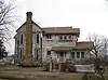 Jackson Brown House |
June 27, 1980 (#80003299) |
1200 S. Muskogee Pl. 35°08′53″N 96°29′25″W |
Wewoka | |
| 3 | Silas L. Brown House | August 5, 1985 (#85001697) |
107 S. Seminole 35°09′29″N 96°29′12″W |
Wewoka | ||
| 4 | W.E. Grisso Mansion | 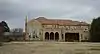 W.E. Grisso Mansion |
January 27, 1975 (#75001573) |
612 State Highway 9E 35°14′50″N 96°39′52″W |
Seminole | |
| 5 | Home Stake Oil and Gas Company Building | 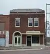 Home Stake Oil and Gas Company Building |
May 14, 1986 (#86001094) |
315 E. Broadway 35°13′27″N 96°40′04″W |
Seminole | |
| 6 | Hotel Aldridge | 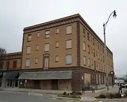 Hotel Aldridge |
May 14, 1986 (#86001083) |
3rd St. and Wewoka Ave. 35°09′24″N 96°29′29″W |
Wewoka | |
| 7 | J. Coody Johnson Building | 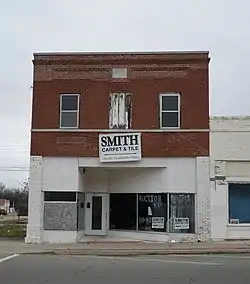 J. Coody Johnson Building |
August 5, 1985 (#85001744) |
124 N. Wewoka St. 35°09′35″N 96°29′28″W |
Wewoka | |
| 8 | Konawa Armory | 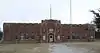 Konawa Armory |
May 20, 1994 (#94000483) |
625 N. State St. 34°57′51″N 96°45′05″W |
Konawa | |
| 9 | Mekasukey Academy | March 28, 1974 (#74001668) |
Southwest of Seminole 35°11′25″N 96°43′18″W |
Seminole | ||
| 10 | Rosenwald Hall | Rosenwald Hall |
September 28, 1984 (#84003427) |
College St. 35°10′27″N 96°35′56″W |
Lima | |
| 11 | Roulston-Rogers Site |  Roulston-Rogers Site |
November 27, 1978 (#78002262) |
Address Restricted |
Sasakwa | |
| 12 | Seminole County Courthouse |  Seminole County Courthouse |
August 24, 1984 (#84003429) |
120 S. Wewoka Ave. 35°09′29″N 96°29′27″W |
Wewoka | |
| 13 | Seminole Municipal Building | Seminole Municipal Building |
September 8, 2015 (#15000580) |
401 N. Main St. 35°13′36″N 96°40′07″W |
Seminole | |
| 14 | Seminole Whipping Tree |  Seminole Whipping Tree |
May 22, 1981 (#81000468) |
120 S. Wewoka Ave. 35°09′29″N 96°29′28″W |
Wewoka | |
| 15 | Sinclair Loading Rack |  Sinclair Loading Rack |
August 5, 1985 (#85001698) |
U.S. Route 270 35°12′57″N 96°38′20″W |
Seminole | System for loading oil of Sinclair Oil Company into railroad tankcars. Demolished. |
| 16 | Strother Memorial Chapel | 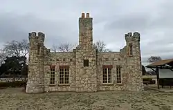 Strother Memorial Chapel |
September 2, 2003 (#03000880) |
1201 Van Dr. (inside the Maple Grove Cemetery) 35°14′02″N 96°41′08″W |
Seminole | |
| 17 | Wewoka Switch and Side Tracks | Wewoka Switch and Side Tracks |
September 26, 1985 (#85002475) |
State Highway 56 35°09′39″N 96°29′28″W |
Wewoka |
See also
| Wikimedia Commons has media related to National Register of Historic Places in Seminole County, Oklahoma. |
References
- The latitude and longitude information provided in this table was derived originally from the National Register Information System, which has been found to be fairly accurate for about 99% of listings. Some locations in this table may have been corrected to current GPS standards.
- "National Register of Historic Places: Weekly List Actions". National Park Service, United States Department of the Interior. Retrieved on January 29, 2021.
- Numbers represent an alphabetical ordering by significant words. Various colorings, defined here, differentiate National Historic Landmarks and historic districts from other NRHP buildings, structures, sites or objects.
- "National Register Information System". National Register of Historic Places. National Park Service. March 13, 2009.
- The eight-digit number below each date is the number assigned to each location in the National Register Information System database, which can be viewed by clicking the number.
| Topics | |
|---|---|
| Lists by state |
|
| Lists by insular areas | |
| Lists by associated state | |
| Other areas | |
| Related | |
| |
Municipalities and communities of Seminole County, Oklahoma, United States | ||
|---|---|---|
| Cities | Seminole County map | |
| Towns | ||
| Unincorporated communities |
| |
| Indian reservations | ||
| Footnotes | ‡This populated place also has portions in an adjacent county or counties | |
| ||
This article is issued from Wikipedia. The text is licensed under Creative Commons - Attribution - Sharealike. Additional terms may apply for the media files.