Chase County, Nebraska
Chase County is a county in the U.S. state of Nebraska. As of the 2010 United States Census, the population was 3,966.[1] Its county seat is Imperial.[2]
Chase County | |
|---|---|
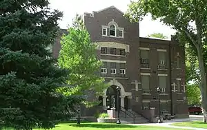 Chase County courthouse in Imperial | |
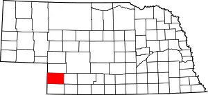 Location within the U.S. state of Nebraska | |
 Nebraska's location within the U.S. | |
| Coordinates: 40°32′N 101°41′W | |
| Country | |
| State | |
| Founded | 27 February 1873 (authorized) 1886 (organized) |
| Named for | Champion S. Chase |
| Seat | Imperial |
| Largest city | Imperial |
| Area | |
| • Total | 897 sq mi (2,320 km2) |
| • Land | 894 sq mi (2,320 km2) |
| • Water | 3.1 sq mi (8 km2) 0.5%% |
| Population | |
| • Estimate (2018) | 3,977 |
| • Density | 4.4/sq mi (1.7/km2) |
| Time zone | UTC−7 (Mountain) |
| • Summer (DST) | UTC−6 (MDT) |
| Congressional district | 3rd |
| Website | www |
In the Nebraska license plate system, Chase County is represented by the prefix 72 (it had the 72nd-most vehicles registered in the state when the license plate system was established in 1922).
History
Chase County was named after Champion S. Chase, who served as mayor of Omaha for seven years and was Nebraska's first Attorney General.
Chase County was separated from Hayes County by the Nebraska legislature on February 27, 1873, although the county was not organized until 1886.[3][4]
It was once said that, excluding ranch owners, their wives, and their cooks, at the time Chase County was organized it was populated entirely by cowboys. Part of the reason for such a statement may have been the fact that at one time Frenchman Creek and its main branch the Stinking Water Creek were used as watering stops for cattle drives that traveled from Texas to the Union Pacific railhead at Ogallala. These trails are known as the Western or Great Western trails.[5][6]
Chase County sits in the region once referred to as the Great American Desert. However, on the broad, fertile plateau, early settlers quickly discovered that Chase County's dark sandy loam soil was excellent for farming.
The railroad came to Chase County in 1892, reaching Wauneta on January 28.[7] It was built by a division of the Chicago, Burlington and Quincy Railroad. This line left the main line near Culbertson and terminated in Imperial.
National Register of Historic Places listings
- Imperial
- Wauneta
- Wauneta Roller Mills (listed 2008)[9]
- Champion
- Rural Areas
Law and government
Chase County is served by a three-member Board of Commissioners. County officials are directly elected. It is a part of the 44th Legislative District of the Nebraska Legislature.[13]
Geography
Chase County is on the west edge of Nebraska. Its west boundary line abuts the east boundary line of the state of Colorado. According to the US Census Bureau, the county has a total area of 897 square miles (2,320 km2), of which 894 square miles (2,320 km2) is land and 3.1 square miles (8.0 km2) (0.3%) is water.[14]
Chase County is geographically diverse. The spring-fed Frenchman Creek crosses the county from west to southeast. From Enders to Wauneta the path of the creek exposes limestone outcroppings. North of Wauneta is an area of significant loess deposits, including the typical steep-walled canyons. Rolling Sandhill formations are found in the north-central and southwestern areas of the county.
The Pierre Shale of Upper Cretaceous Age is the underlying structure of the region. At Enders Dam this formation is found at a depth of 175 feet (53 m) below the valley floor. The Ogallala Formation of Pliocene Age overlies the Pierre Shale. The Ogallala Formation is composed of fine to course sand, some gravel, calcareous silt, silty sands, silts and clays. Various degrees of calcareous cementation occur, resulting in lenses of varying loose unconsolidated to very firm compact materials at irregular intervals. The Ogallala beds lie almost horizontal and structural irregularities, such as faulting, have been observed in the area.[15]
The Ogallala Formation is of vital importance to the county and the surrounding areas. The associated Ogallala Aquifer is the primary source of water for the population and livestock, and an important input into agricultural economy of the county.
Adjacent counties
- Hayes County – east
- Dundy County – south
- Yuma County, Colorado – southwest
- Phillips County, Colorado – west
- Perkins County – north
Demographics
| Historical population | |||
|---|---|---|---|
| Census | Pop. | %± | |
| 1880 | 70 | — | |
| 1890 | 4,807 | 6,767.1% | |
| 1900 | 2,559 | −46.8% | |
| 1910 | 3,613 | 41.2% | |
| 1920 | 4,939 | 36.7% | |
| 1930 | 5,484 | 11.0% | |
| 1940 | 5,310 | −3.2% | |
| 1950 | 5,176 | −2.5% | |
| 1960 | 4,317 | −16.6% | |
| 1970 | 4,129 | −4.4% | |
| 1980 | 4,758 | 15.2% | |
| 1990 | 4,381 | −7.9% | |
| 2000 | 4,068 | −7.1% | |
| 2010 | 3,966 | −2.5% | |
| 2018 (est.) | 3,977 | [18] | 0.3% |
| US Decennial Census[19] 1790-1960[20] 1900-1990[21] 1990-2000[22] 2010-2013[1] | |||
As of the 2000 United States Census,[23] there were 4,068 people, 1,662 households, and 1,163 families in the county. The population density was 4 people per square mile (2/km2). There were 1,927 housing units at an average density of 2 per square mile (1/km2). The racial makeup of the county was 97.81% White, 0.17% Black or African American, 0.10% Native American, 0.17% Asian, 0.02% Pacific Islander, 1.47% from other races, and 0.25% from two or more races. 3.42% of the population were Hispanic or Latino of any race. 44.6% were of German, 13.0% American, 12.3% English and 7.1% Irish ancestry.
There were 1,662 households, out of which 30.60% had children under the age of 18 living with them, 62.10% were married couples living together, 5.50% had a female householder with no husband present, and 30.00% were non-families. 27.30% of all households were made up of individuals, and 13.80% had someone living alone who was 65 years of age or older. The average household size was 2.39 and the average family size was 2.91.
The county population contained 25.20% under the age of 18, 5.90% from 18 to 24, 23.90% from 25 to 44, 24.00% from 45 to 64, and 21.10% who were 65 years of age or older. The median age was 42 years. For every 100 females there were 96.60 males. For every 100 females age 18 and over, there were 94.80 males.
The median income for a household in the county was $32,351, and the median income for a family was $39,225. Males had a median income of $27,554 versus $17,602 for females. The per capita income for the county was $17,490. About 7.90% of families and 9.60% of the population were below the poverty line, including 10.50% of those under age 18 and 9.00% of those age 65 or over.
Economy
Chase County economy is based on agriculture. A third of the county's area is under irrigation; another fourth is used for dry farming. The rest is rangeland. Wheat, corn, edible beans (pintos, kidneys and great northerns), soybeans and sugar beets are the principal crops. Livestock production is equally important in the county's economy.[24] In 2007, sales of agricultural products exceeded $125 Million, with Corn ($96 Million) and Wheat ($11 Million) being the primary crops.[25]
Transportation
The main highway routes crossing Chase County are U.S. Route 6 which crosses east–west and Nebraska Highway 61 which crosses north–south.[26] The county is served by the Nebraska Kansas & Colorado Railway. NKCR is an operating company of OmniTRAX. This short line operates the branch line which interchanges with the BNSF. This line enters the county near the southeastern corner passing through Wauneta and Enders, terminating at Imperial.[27]
Major highways
Communities
City
- Imperial (county seat)
Politics
Chase County voters are strongly Republican. In no national election since 1936 has the county selected a Democratic Party candidate. In 2020, Donald Trump won the highest share of the vote ever in the county at 87.0%. Republicans also hold a significant advantage in voter registration in Chase County, with 1,902 registered Republicans compared with just 282 registered Democrats as of 2021.[28]
| Year | Republican | Democratic | Third Parties |
|---|---|---|---|
| 2020 | 87.0% 1,740 | 11.3% 226 | 1.7% 34 |
| 2016 | 86.8% 1,648 | 9.0% 171 | 4.2% 79 |
| 2012 | 84.8% 1,584 | 13.6% 254 | 1.6% 29 |
| 2008 | 80.1% 1,477 | 18.5% 341 | 1.4% 26 |
| 2004 | 83.7% 1,652 | 15.3% 302 | 1.0% 19 |
| 2000 | 80.3% 1,505 | 16.3% 306 | 3.4% 64 |
| 1996 | 68.9% 1,277 | 19.7% 365 | 11.4% 212 |
| 1992 | 48.0% 1,000 | 19.1% 398 | 32.9% 685 |
| 1988 | 69.5% 1,446 | 28.7% 597 | 1.9% 39 |
| 1984 | 80.9% 1,697 | 17.6% 368 | 1.5% 32 |
| 1980 | 75.8% 1,593 | 15.4% 324 | 8.9% 186 |
| 1976 | 59.2% 1,146 | 37.4% 725 | 3.4% 66 |
| 1972 | 81.1% 1,318 | 18.9% 307 | |
| 1968 | 67.8% 1,171 | 21.0% 363 | 11.2% 193 |
| 1964 | 54.4% 1,081 | 45.6% 907 | |
| 1960 | 69.3% 1,482 | 30.7% 657 | |
| 1956 | 68.3% 1,444 | 31.7% 670 | |
| 1952 | 80.7% 1,941 | 19.3% 463 | |
| 1948 | 59.8% 1,094 | 40.2% 736 | |
| 1944 | 69.0% 1,444 | 31.0% 648 | |
| 1940 | 63.3% 1,557 | 36.7% 904 | |
| 1936 | 39.9% 1,031 | 57.7% 1,493 | 2.4% 63 |
| 1932 | 38.6% 948 | 57.4% 1,408 | 4.0% 99 |
| 1928 | 71.9% 1,540 | 27.0% 579 | 1.1% 23 |
| 1924 | 48.2% 919 | 29.9% 570 | 22.0% 419 |
| 1920 | 66.2% 976 | 28.1% 414 | 5.8% 85 |
| 1916 | 37.4% 369 | 55.8% 551 | 6.8% 67 |
| 1912 | 25.1% 197 | 33.4% 262 | 41.5% 325 |
| 1908 | 51.6% 400 | 43.6% 338 | 4.8% 37 |
| 1904 | 62.4% 329 | 21.1% 111 | 16.5% 87 |
| 1900 | 51.6% 313 | 45.1% 274 | 3.3% 20 |
References
- "State & County QuickFacts". US Census Bureau. Archived from the original on July 8, 2011. Retrieved September 17, 2013.
- "Find a County". National Association of Counties. Archived from the original on 31 May 2011. Retrieved 7 June 2011.
- Fitzpatrick, Lilian Linder (1925). Nebraska Place-Names. Lincoln: University of Nebraska Studies in Language, Literature, and Criticism. p. 35. Retrieved December 14, 2014.
- "Chase County". Nebraska Association of County Officials. Retrieved December 14, 2014.
- Western Trail, The Handbook of Texas
- The Great Western Trail
- Chase County Tourism
- Chase County Tourism
- Nebraska State Historical Society
- Chase County Tourism
- "NebraskaStudies.Org". Archived from the original on 2008-10-17. Retrieved 2009-06-28.
- Chase County Tourism
- Nebraska Legislature
- "2010 Census Gazetteer Files". US Census Bureau. August 22, 2012. Archived from the original on November 13, 2013. Retrieved December 6, 2014.
- Bureau of Reclamation - Enders Dam Data Archived May 13, 2009, at the Wayback Machine
- Church Grove Recreation Area, Enders NE Google Maps (accessed 17 January 2019)
- Enders Grove State Recreation Area, Enders NE Google Maps (accessed 17 January 2019)
- "Population and Housing Unit Estimates". Retrieved December 28, 2019.
- "US Decennial Census". US Census Bureau. Retrieved December 6, 2014.
- "Historical Census Browser". University of Virginia Library. Retrieved December 6, 2014.
- "Population of Counties by Decennial Census: 1900 to 1990". US Census Bureau. Retrieved December 6, 2014.
- "Census 2000 PHC-T-4. Ranking Tables for Counties: 1990 and 2000" (PDF). US Census Bureau. Retrieved December 6, 2014.
- "U.S. Census website". US Census Bureau. Retrieved 31 January 2008.
- "eReference Desk, Chase County, Nebraska". Archived from the original on 2010-05-28. Retrieved 2009-03-01.
- 2007 Census of Agriculture, USDA, National Agricultural Statistics Service
- Nebraska Highway Logbook
- Nebraska Kansas Colorado Railway Archived May 6, 2009, at the Wayback Machine
- "2021 Eligible Voter Statistics". Nebraska Secretary of State. January 8, 2021. Retrieved January 18, 2021.
- Election Results
External links
Places adjacent to Chase County, Nebraska | ||||||||||
|---|---|---|---|---|---|---|---|---|---|---|
| ||||||||||
Municipalities and communities of Chase County, Nebraska, United States | ||
|---|---|---|
| City | Map of Nebraska highlighting Chase County | |
| Villages | ||
| CDPs | ||
| ||

| Authority control |
|---|