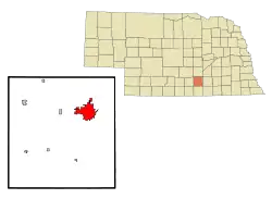
Hastings, Nebraska
Hastings is a city and the county seat of Adams County, Nebraska, United States.[5] The population was 24,907 at the 2010 census. It is known as the town where Kool-Aid was invented by Edwin Perkins in 1927, and celebrates that event with the Kool-Aid Days festival every August.[6] Hastings is also known for Fisher Fountain, and during World War II operated the largest Naval Ammunition Depot in the United States.
Hastings, Nebraska | |
|---|---|
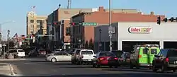 Downtown Hastings: 2nd Street, looking eastward (2012) | |
 | |
| Coordinates: 40°35′21″N 98°23′30″W | |
| Country | United States |
| State | Nebraska |
| County | Adams |
| Area | |
| • Total | 14.77 sq mi (38.25 km2) |
| • Land | 14.59 sq mi (37.80 km2) |
| • Water | 0.18 sq mi (0.46 km2) |
| Elevation | 1,926 ft (587 m) |
| Population | |
| • Total | 24,907 |
| • Estimate (2019)[3] | 24,692 |
| • Density | 1,692.04/sq mi (653.29/km2) |
| Time zone | UTC−6 (CST) |
| • Summer (DST) | UTC−5 (CDT) |
| ZIP codes | 68901-68902 |
| Area code | 402 |
| FIPS code | 31-21415 |
| GNIS ID | 0829848[4] |
| U.S. Routes | |
| Website | cityofhastings.org |
History
Hastings was founded in 1872 at the intersection of the Burlington and Missouri River Railroad and the St. Joseph and Denver City Railroad. It was named for Colonel D. T. Hastings of the St. Joseph and Grand Island Railroad, who was instrumental in building the railroad through Adams County.[7][8][9] The area was previously open plain: the Donner party passed through on its way to California in 1846 and a pioneer cemetery marker in Hastings bears an inscription taken from Tamsen Donner's journal: "The country between the Blue and the Platte is beautiful beyond compare. Never have I seen so varied a country so suitable to cultivation."[10] In the 1870s, railroads lured European immigrants to the new state of Nebraska with advertisements. Hastings' first settlers were English, from Liverpool, and were quickly joined by other English, Irish, Germans, Danes, and Germans from Russia.[11]
Between 1872 and 1880, when the population had grown to 2,800, Hastings was a boomtown. Settlers first built sod houses, dugouts, and shanties, then houses and stores. The city was incorporated in April 1874, and in September 1878, after a five-year Great County Seat War, the county seat was transferred to Hastings from Juniata.[12] However, a fire in 1879 destroyed 33 buildings downtown. The city was rebuilt between 1880 and 1890 in fireproof materials and in a more planned fashion, with characteristically ornate Victorian buildings, many designed by Charles C. Rittenhouse, the first practicing architect in Adams County and also mayor for ten years.[13] Thanks to the railroads, the city enjoyed great prosperity during the Gilded Age. The population grew to 13,500.[14] This period of expansion ended with the drought and agricultural depression of the 1890s; the town's population fell to 7,000 and would not reach 15,000 until 1930.
Hastings saw renewed growth from 1900 to 1930, which is reflected by buildings in the Craftsman, Prairie, Colonial Revival, and American Foursquare styles. The leading Arts and Crafts architect was Claude W. Way.[13] Hastings had four brickyards and in 1911 was producing more bricks than any other city in Nebraska,[15] and all the paving bricks.[16] During this period, the city also became known as the cigar-making capital of Nebraska. The largest cigar factory, the Kipp Cigar Company, was by 1921 hand-rolling one-fifth of all cigars produced in Nebraska; in 1925 it produced half, a total of 10 million.[17][18] Cigars lost their popularity to cigarettes between the two World Wars, and in the 1930s the Great Depression again brought the town's expansion to a halt.
In 1942, the Naval Ammunition Depot was constructed, initiating explosive growth: Hastings' population grew from 15,000 to 23,000 in under a year and there was a critical shortage of housing, which prompted both alteration of existing housing stock and rapid construction of new neighborhoods.[19] Once World War II ended, staff was reduced at the ammunition depot, bringing Hastings' last growth period to an end in 1950, and the depot eventually closed.
Today, Heartwell Park and Central Hastings, two of the oldest neighborhoods, are listed on the National Register of Historic Places.[20] The Hastings Symphony Orchestra performs in the Chautauqua Pavilion, built in 1907 and on the National Register of Historic Places, while the Hastings Community Theatre performs in the auditorium of the former Spencer Park School, built during the housing shortage of the 1940s. The city has adapted several of its historic buildings to new uses. Central Community College is housed in buildings of the former Naval Ammunition Depot., St. Michael's Elementary School (formerly the Lincoln Elementary School building), built in 1912, is now the police headquarters. The Clarke Hotel, built in 1914 and also on the National Register of Historic Places, is now the Kensington, a home for senior citizens.[21] Spencer Park, an 840-unit "village" built to house workers in the 1940s, is now Good Samaritan Retirement Village.[16]
On June 24, 2007, Hastings won Yahoo's Greenest City in America competition.[22]
Geography
According to the United States Census Bureau, the city has a total area of 13.66 square miles (35.38 km2), of which 13.48 square miles (34.91 km2) is land and 0.18 square miles (0.47 km2) is water.[23]
Climate
A National Weather Service Forecast Office is located in Hastings, serving central and south-central Nebraska and six counties in north-central Kansas. The data below are from the WRCC.[24]
| Climate data for Hastings, NE | |||||||||||||
|---|---|---|---|---|---|---|---|---|---|---|---|---|---|
| Month | Jan | Feb | Mar | Apr | May | Jun | Jul | Aug | Sep | Oct | Nov | Dec | Year |
| Record high °F (°C) | 76 (24) |
80 (27) |
90 (32) |
96 (36) |
105 (41) |
110 (43) |
116 (47) |
111 (44) |
105 (41) |
97 (36) |
86 (30) |
80 (27) |
116 (47) |
| Average high °F (°C) | 35.1 (1.7) |
40.2 (4.6) |
50.6 (10.3) |
63.2 (17.3) |
73.4 (23.0) |
83.6 (28.7) |
89.6 (32.0) |
87.5 (30.8) |
78.9 (26.1) |
66.8 (19.3) |
50.3 (10.2) |
37.9 (3.3) |
63.1 (17.3) |
| Average low °F (°C) | 13.6 (−10.2) |
18.1 (−7.7) |
26.6 (−3.0) |
38.3 (3.5) |
49.1 (9.5) |
59.2 (15.1) |
64.3 (17.9) |
62.2 (16.8) |
52.8 (11.6) |
40.7 (4.8) |
27.4 (−2.6) |
17.5 (−8.1) |
39.2 (4.0) |
| Record low °F (°C) | −30 (−34) |
−22 (−30) |
−15 (−26) |
5 (−15) |
22 (−6) |
34 (1) |
45 (7) |
40 (4) |
26 (−3) |
4 (−16) |
−7 (−22) |
−23 (−31) |
−30 (−34) |
| Average precipitation inches (mm) | 0.57 (14) |
0.85 (22) |
1.48 (38) |
2.74 (70) |
4.02 (102) |
3.95 (100) |
3.32 (84) |
3.21 (82) |
2.60 (66) |
1.60 (41) |
1.04 (26) |
0.73 (19) |
26.11 (664) |
| Average snowfall inches (cm) | 5.2 (13) |
6.5 (17) |
5.1 (13) |
1.7 (4.3) |
0.1 (0.25) |
0 (0) |
0 (0) |
0 (0) |
0.1 (0.25) |
0.6 (1.5) |
2.4 (6.1) |
4.9 (12) |
26.6 (67.4) |
| Source: https://wrcc.dri.edu/cgi-bin/cliMAIN.pl?ne3660 | |||||||||||||
Demographics
| Historical population | |||
|---|---|---|---|
| Census | Pop. | %± | |
| 1880 | 2,817 | — | |
| 1890 | 13,584 | 382.2% | |
| 1900 | 7,188 | −47.1% | |
| 1910 | 9,338 | 29.9% | |
| 1920 | 11,647 | 24.7% | |
| 1930 | 15,490 | 33.0% | |
| 1940 | 15,145 | −2.2% | |
| 1950 | 20,211 | 33.4% | |
| 1960 | 21,412 | 5.9% | |
| 1970 | 23,580 | 10.1% | |
| 1980 | 23,045 | −2.3% | |
| 1990 | 22,837 | −0.9% | |
| 2000 | 24,064 | 5.4% | |
| 2010 | 24,907 | 3.5% | |
| 2019 (est.) | 24,692 | [3] | −0.9% |
| U.S. Decennial Census[25] 2018 Estimate[26] | |||
Hastings is the principal city of the Hastings, Nebraska Micropolitan Statistical Area, which consists of Adams and Clay counties.
2010 census
As of the census[2] of 2010, there were 24,907 people, 10,110 households, and 6,160 families residing in the city. The population density was 1,847.7 inhabitants per square mile (713.4/km2). There were 10,847 housing units at an average density of 804.7 per square mile (310.7/km2). The racial makeup of the city was 90.4% White, 1.0% African American, 0.5% Native American, 1.7% Asian, 0.1% Pacific Islander, 5.0% from other races, and 1.5% from two or more races. Hispanic or Latino of any race were 9.8% of the population.
There were 10,110 households, of which 29.6% had children under the age of 18 living with them, 46.2% were married couples living together, 10.5% had a female householder with no husband present, 4.2% had a male householder with no wife present, and 39.1% were non-families. 32.7% of all households were made up of individuals, and 14.3% had someone living alone who was 65 years of age or older. The average household size was 2.35 and the average family size was 2.97.
The median age in the city was 36.8 years. 23.9% of residents were under the age of 18; 12.4% were between the ages of 18 and 24; 22.8% were from 25 to 44; 25.1% were from 45 to 64; and 15.8% were 65 years of age or older. The gender makeup of the city was 49.4% male and 50.6% female.
2000 census
As of the census of 2000, there were 24,064 people, 9,610 households, and 5,948 families residing in the city. The population density was 2,448.5 people per square mile (945.2/km2). There were 10,333 housing units at an average density of 1,051.4 per square mile (405.9/km2). The racial makeup of the city was 93.39% White, 0.79% African American, 0.42% Native American, 2.02% Asian, 0.04% Pacific Islander, 2.39% from other races, and 0.96% from two or more races. Hispanic or Latino of any race were 5.58% of the population.
There were 9,610 households, out of which 29.6% had children under the age of 18 living with them, 49.8% were married couples living together, 9.2% had a female householder with no husband present, and 38.1% were non-families. 31.5% of all households were made up of individuals, and 14.2% had someone living alone who was 65 years of age or older. The average household size was 2.36 and the average family size was 2.98.
In the city, the population was spread out, with 23.6% under the age of 18, 12.8% from 18 to 24, 26.5% from 25 to 44, 20.5% from 45 to 64, and 16.7% who were 65 years of age or older. The median age was 36 years. For every 100 females, there were 93.7 males. For every 100 females age 18 and over, there were 90.1 males.
As of 2000 the median income for a household in the city was $35,461, and the median income for a family was $44,688. Males had a median income of $29,633 versus $21,262 for females. The per capita income for the city was $17,941. About 5.6% of families and 10.0% of the population were below the poverty line, including 10.6% of those under age 18 and 6.7% of those age 65 or over.
Transportation
Amtrak, the national passenger rail system, provides service through Hastings, operating its California Zephyr daily in each direction between Chicago and Emeryville, California, across the bay from San Francisco. Hastings is served by major highways, including east-west U.S. Highways 6 and 34, and north-south U.S. Highway 281. Burlington Avenue is the main street running from south to north in Hastings; northward it leads to U.S. 281. Hastings is approximately 14 miles (23 km) south of Interstate 80.
Hastings Municipal Airport, owned and operated by the City of Hastings, serves the city.
There is currently no Uber taxi service or other internet-ordered taxi services or ride-sharing services.
Education
The school district is the Hastings Public Schools.
Hastings has several elementary schools. The largest public elementary is Longfellow. Others are Hawthorne, Watson, Alcott, and Lincoln. Zion Lutheran serves students in grades K–8. There was a new middle school that opened in the fall of 2008. The high schools are Hastings High School (public) Athletics Class B and St. Cecilia's (Catholic) Athletics class C–2.
Just outside town is Adams Central Junior-Senior High School (public rural) Athletics Class C.
Hastings College is a private liberal arts college, affiliated with the Presbyterian Church (USA), and founded in 1882. Central Community College, a two-year technical college, began serving students in 1966, and it occupies the site of the old Naval Ammunition Depot.[20]
Fisher Fountain
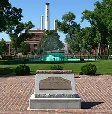
The Jacob Fisher Rainbow Fountain in Highland Park, Hastings, is the largest water fountain between Chicago and Denver. The fountain shoots continuously changing arrays of water jets (reaching heights of 67 feet) while green, yellow, orange, red, magenta, and blue lights illuminate the water in varying patterns.
Fisher Fountain was originally a temporary exhibit at the 1932 Adams County Fair, called the Electric Fountain. It was invented by Edward R. Howard and became a symbol of hope during the Great Depression and Dust Bowl. Because of its popularity, it was moved to the park and made permanent. A competition among schoolchildren to rename it resulted in two winning names that were combined: Rainbow Fountain, and Fisher Fountain after Mayor Jacob Fisher.[27]
Fisher Fountain was renovated in 1982 but was then dynamited by vandals in 1984. Its destruction aroused a strong community response. $63,000 was raised to rebuild it, and it was rededicated on Mother's Day in 1985.[28]
Hastings Museum
The Hastings Museum of Natural and Cultural History is in an art deco building funded by $75,000 from the Works Progress Administration and completed in 1939. Albert Brooking, who founded the museum in 1926 and provided it with many exhibits, including Indian relics, fossils, and the largest private collection of mounted birds in the US,[29] was buried in the basement in 1946.[30] The museum currently houses the Lied Super Screen Theatre, McDonald Planetarium, and local and regional exhibits including the largest diorama of whooping and sandhill cranes in the world.[31] The Adams County Historical Society is located within the museum.
Naval Ammunition Depot
The Naval Ammunition Depot, constructed on 49,000 acres (200 km2) southeast of Hastings and in operation from 1942 to 1946, was the largest United States World War II naval munitions plant, encompassing over 2,200 structures valued at $71 million. Hastings was chosen as the location for the plant because of its central location. In 1945 it employed 6,692 civilians in addition to 125 officers and 1,800 enlistees.[32]
The plant was reactivated in the Korean War but decommissioned between 1958 and 1966, and the site now houses a US Department of Agriculture research station, training facilities for the National Guard and Reserves, an industrial park, Central Community College, and a golf course.
Parks and recreation
Hastings has twenty parks and recreational facilities throughout the city. The city offers recreational and leisure programs and operates the Aquacourt Water Park, the City Auditorium, Lake Hastings, Chautauqua Pavilion, Duncan Field, the Pioneer Spirit Trail, Smith Softball Complex, Brickyard Park Amphitheater, and Heartwell Lake.[33]
Media
The principal newspaper in Hastings is the Hastings Tribune, published six days a week.[34]
KNHL's studio is located north of Hastings on U.S. 281.
Notable people
- Marc Boerigter, football player
- Stan Campbell, football player
- Adam Carriker, football player
- Clarence L. "Ben" Coates, computer scientist
- Sandy Dennis, theater and Academy Award-winning film actress
- Charles Henry Dietrich, Governor of Nebraska and U.S. Senator
- Stephen Goodin, football player
- Francis Greenlief, United States Army Major General and Chief of the National Guard Bureau
- Neal Hefti, jazz musician and composer
- Sheila Hicks, fiber artist
- Johnny Hopp, Major League baseball player
- Rollin Kirby, political cartoonist [16]
- Les Nunamaker, Major League baseball player
- Tom Osborne, University of Nebraska football coach and Congressman
- Edwin Perkins, inventor of Kool-Aid
- Randall Ray Rader, Chief Judge of the United States Court of Appeals for the Federal Circuit.
- Carrie Renfrew (1858–1948), author
- Fred A. Seaton, U.S. Secretary of the Interior 1956–61.
- Rick Sheehy, lieutenant governor of Nebraska 2005–13
- Teddi Smith, Playboy Playmate (July 1960)
- Zach Sterup, football player
- Jeri Kehn Thompson, political commentator, wife of Sen. Fred Thompson
- Gerald Lee Warren, journalist
See also
References
- "2019 U.S. Gazetteer Files". United States Census Bureau. Retrieved July 26, 2020.
- "U.S. Census website". United States Census Bureau. Retrieved 2012-06-24.
- "Population and Housing Unit Estimates". United States Census Bureau. May 24, 2020. Retrieved May 27, 2020.
- "US Board on Geographic Names". United States Geological Survey. 2007-10-25. Retrieved 2008-01-31.
- "Find a County". National Association of Counties. Retrieved 2011-06-07.
- "Kool-Aid Days". Retrieved 2012-11-16.
- A History of the Origin of the Place Names in Nine Northwestern States connected with the Chicago & North Western and Chicago, St. Paul, Minneapolis & Omaha Railways, 2nd ed. Chicago, 1908, OCLC 38707348, p. 11.
- Nebraska History 58 (1977) p. 539.
- Elton Perkey, Perkey's Nebraska Place-Names, Publications of the Nebraska State Historical Society 28, Lincoln: Nebraska State Historical Society, 1982, OCLC 9488791, p. 2.
- Elizabeth H. Spilinek, Hastings: Then and Now, Charleston, South Carolina: Arcadia, 2009, ISBN 978-0-7385-6121-9, p. 9.
- Spilinek, p. 9.
- Catherine Renschler, Prairie to Prominence: Hastings' First 10 Years at Adams County Historical Society, retrieved April 6, 2010.
- Rittenhouse and Way: Architects of Hastings' First Half Century at Adams County Historical Society, retrieved April 6, 2010.
- Spilinek, p. 9.
- Central Hastings Historic District at Adams County Historical Society, retrieved April 6, 2010.
- Elizabeth Spilinek, History Archived 2010-04-20 at the Wayback Machine, Hastings, Nebraska Chamber of Commerce, 2006, retrieved April 6, 2010.
- Spilinek, p. 72.
- Kipp Cigar Company at Adams County Historical Society, retrieved April 4, 2010.
- Spilinek, p. 10.
- Spilinek, p. 10.
- Spilinek, p. 10.
- Dawn Kawamoto, "Yahoo names greenest city in America," CNET news blog June 25, 2007, retrieved 4 April 2010.
- "US Gazetteer files 2010". United States Census Bureau. Archived from the original on 2012-07-02. Retrieved 2012-06-24.
- "HASTINGS 4 N, NEBRASKA - Climate Summary". wrcc.dri.edu. Retrieved 2018-07-19.
- United States Census Bureau. "Census of Population and Housing". Retrieved June 24, 2013.
- "Population Estimates". United States Census Bureau. Retrieved June 8, 2018.
- Fountain to Fountain Tour Book at Adams County Historical Society, retrieved April 4, 2010. According to Spilinek, p. 79, it was set up on the grounds of Hastings Utilities.
- Adams County Historical Society.
- J. Harold Hamil, Adams County, Who's Who in Nebraska, 1940.
- Spilinek, p. 80.
- Recreation and Places of Interest Archived 2010-05-27 at the Wayback Machine, Nebraska State Legislature.
- The Naval Ammunition Depot at Adams County Historical Society, retrieved April 4, 2010.
- Parks & Recreation Archived 2011-05-06 at the Wayback Machine, City of Hastings Nebraska, retrieved April 5, 2010.
- "About Us," Archived 2010-10-21 at Archive.today Hastings Tribune.
Sources
- Elizabeth Spilinek, John B Chrise, Keith Enockson, Brett Erickson. Connections to the Past: The Connected History of Hastings, Nebraska as Told Through its Historic Architecture. Video. Adams County Historical Society, 2007. OCLC 237049053
External links
- City of Hastings, NE
- Hastings Economic Development Corporation
- Visit Hastings Nebraska!
- Hastings Museum of Natural and Cultural History
- Hastings Tribune
Municipalities and communities of Adams County, Nebraska, United States | ||
|---|---|---|
| City | Map of Nebraska highlighting Adams County | |
| Villages | ||
| Townships | ||
| Unincorporated communities | ||
| Footnotes | ‡This populated place also has portions in an adjacent county or counties | |
| ||

| Authority control |
|---|