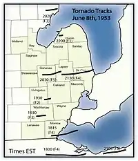
Flint–Worcester tornado outbreak sequence
An extremely devastating and deadly tornado outbreak sequence impacted the Midwestern and Northeastern United States at the beginning of June. It included two tornadoes that caused at least 90 deaths each—an F5 tornado occurring in Flint, Michigan, on June 8, 1953, and an F4 tornado in Worcester, Massachusetts, on June 9.[nb 1][nb 2] These tornadoes are among the deadliest in United States history and were caused by the same storm system that moved eastward across the nation. The tornadoes are also related together in the public mind because, for a brief period following the Worcester tornado, it was debated in the U.S. Congress whether recent atomic bomb testing in the upper atmosphere had caused the tornadoes. Congressman James E. Van Zandt (R-Penn.) was among several members of Congress who expressed their belief that the June 4th bomb testing created the tornadoes, which occurred far outside the traditional tornado alley. They demanded a response from the government. Meteorologists quickly dispelled such an assertion, and Congressman Van Zandt later retracted his statement.
 | |
| Type | Tornado outbreak |
|---|---|
| Duration | June 7–9, 1953 |
| Tornadoes confirmed | 50[1] |
| Max. rating1 | F5 tornado |
| Duration of tornado outbreak2 | 3 days |
| Damage | $340.611 million (1953 USD $2.56 billion (2006 USD)[2] |
| Casualties | 247 fatalities, 2,562 injuries |
| Areas affected | Midwestern and Northeastern United States |
Part of the tornado outbreaks of 1953 1Most severe tornado damage; see Fujita scale 2Time from first tornado to last tornado | |
The Flint-Worcester Tornadoes were the most infamous storms produced by a larger outbreak of severe weather that began in Nebraska, Iowa and Wisconsin, before moving across the Great Lakes states, and then into New York and New England. Other F3 and F4 tornadoes struck other locations in Massachusetts, Michigan, New Hampshire and Ohio.[4]
Meteorlogical synopsis
On June 6, a surface low-pressure area formed over Northwestern New Mexico and eventually began to move northeastward into the Great Plains. On June 7, the low-pressure system moved into Southwestern Nebraska with a cold front extending a short distance westward into Northeastern Colorado, a dryline that extended south into Southwestern Texas, and a warm front that extended east-northeastward to near Omaha, Nebraska before turning east-southeastward into Southwestern Indiana. Temperatures across Kansas, Nebraska, and Iowa that afternoon were in the area was up in the upper 70s to lower 90s while dewpoints were in the lower 60s to lower 70s. With shear values of 55 knots in the upper atmosphere, the environment became extremely ripe for the development of severe weather and tornadoes throughout the afternoon and evening. A jet streak formed later that night after an upper-level low formed, which allowed the outbreak to go well into the overnight hours.
By June 8, the surface low and upper-level low had moved into Canada. The surface low occluded with the warm front over the Eastern Great Lakes into Ontario and New York and the cold front extending southwestward into Southeastern Iowa. A surface boundary formed, spanning from Eastern Upper Michigan southwestward into Southwestern Illinois. Upper-level wind shear values were even stronger on this day, reaching as high as 65 knots. Temperatures were in upper 70s to upper 80s with dewpoints in the mid 60s to mid 70s. This allowed for a line of violent tornadic supercells to form across Eastern Lower Michigan into Northwestern Ohio. These storms marched eastward throughout the afternoon before weakening that evening.
On June 9, the cold front from the surface low over Eastern Ontario had moved into New England. A shortwave trough had formed over the region in the upper atmosphere conjuring up extremely strong wind shear values of 100 knots. At the surface, temperatures were in the upper 70s to mid 80s with dewpoints in the mid 60s to lower 70s. Numerous supercell thunderstorm formed along the cold front, spawning wind, hail, and tornadoes before weakening and moving offshore that evening.[5][6]
Confirmed tornadoes
| FU | F0 | F1 | F2 | F3 | F4 | F5 | Total |
|---|---|---|---|---|---|---|---|
| 0 | 14 | 10 | 13 | 7 | 5 | 1 | 50 |
June 7 event
| F# | Location | County / Parish | State | Start coord. |
Time (UTC) | Path length | Max. width | Summary |
|---|---|---|---|---|---|---|---|---|
| F1 | E of Morland | Graham | KS | 39.35°N 100.5°W | 19:00–? | 0.1 miles (0.16 km) | 10 yards (9.1 m) | This tornado, which was accompanied by large hail and strong winds, was the first of three tornadoes produced by the same squall line, which damaged six farmsteads. There was $25,000 in damage. |
| F2 | S of Hill City | Graham | KS | 39.35°N 99.85°W | 19:00–? | 0.1 miles (0.16 km) | 10 yards (9.1 m) | This tornado, which was accompanied by large hail and strong winds, was the second of three tornadoes produced by the same squall line, which damaged six farmsteads. There was $25,000 in damage. |
| F0 | S of Edmond to SSW of Logan | Graham, Norton | KS | 39.53°N 99.83°W | 19:00–? | 10.9 miles (17.5 km) | 10 yards (9.1 m) | This tornado, which was accompanied by large hail and strong winds, was the third of three tornadoes produced by the same squall line, which damaged six farmsteads. There was $25,000 in damage. |
| F1 | WSW of Julesburg (1st tornado) | Sedgwick | CO | 40.98°N 102.28°W | 20:00–? | 0.1 miles (0.16 km) | 10 yards (9.1 m) | First of five tornadoes in the area. This was the only to cause damage, which was limited to small farm buildings and equipment. There was $2,500 in damage. |
| F1 | N of Julesburg | Sedgwick | CO | 41°N 102.27°W | 20:00–? | 0.1 miles (0.16 km) | 10 yards (9.1 m) | Second of five tornadoes in the area. There was no damage value given. |
| F2 | ENE of Mason City to SW of Arcadia | Custer, Sherman | NE | 41.23°N 99.27°W | 20:30–? | 6.6 miles (10.6 km) | 100 yards (91 m) | Farm houses were destroyed and livestock were killed. Barns were leveled as well. Losses totaled $500,000. |
| F2 | WNW of Giltner to SSW of Phillips | Hamilton | NE | 40.78°N 98.17°W | 21:00–? | 6.6 miles (10.6 km) | 10 yards (9.1 m) | Strong tornado damaged sets of farm buildings on three farms while ripping roofs off of homes. There was $25,000 in damage. |
| F0 | S of Phillips | Hamilton | NE | 40.83°N 98.22°W | 21:00–? | 4.1 miles (6.6 km) | 10 yards (9.1 m) | There was $2,500 in damage. |
| F1 | ENE of Rising City to Octavia to WNW of Linwood | Butler | NE | 41.2°N 97.28°W | 21:00–? | 22.7 miles (36.5 km) | 10 yards (9.1 m) | Barns were destroyed on a dozen farms with losses totaling $25,000 in damage. Two people were injured. The CDNS report states that the tornado injured four and was short-lived, implying that this was actually a tornado family. |
| F4 | S of Arcadia to WSW of Ord | Sherman, Valley | NE | 41.33°N 99.13°W | 21:15–? | 15 miles (24 km) | 440 yards (400 m) | 11 deaths – Homes were completely leveled and two cars were destroyed, including one that was thrown a .25 mi (0.40 km) through the air. The worst damage occurred near Arcadia, where a farm was swept away, killing 10 people at a family reunion. Bodies were thrown up to .5 mi (0.80 km) away from the residence. Farm machinery was thrown as well. Losses totaled $500,000. |
| F0 | WSW of Julesburg (2nd tornado) | Sedgwick | CO | 40.98°N 102.21°W | 22:00–? | 0.1 miles (0.16 km) | 10 yards (9.1 m) | Third of five tornadoes in the area. There was no damage. |
| F0 | SW of Julesburg | Sedgwick | CO | 40.97°N 102.3°W | 22:00–? | 0.1 miles (0.16 km) | 10 yards (9.1 m) | Fourth of five tornadoes in the area. There was no damage. |
| F0 | NW of Julesburg | Sedgwick | CO | 41°N 102.3°W | 22:00–? | 0.1 miles (160 m) | 10 yards (9.1 m) | Fifth of five tornadoes in the area. There was no damage. |
| F2 | E of Scotia to Greeley to Spalding | Greeley | NE | 41.47°N 98.63°W | 22:00–? | 20.1 miles (32.3 km) | 10 yards (9.1 m) | This was more than likely a family of tornadoes linked by strong winds. There was one injury and $25,000 in damage. The CDNS report does not list any casualties. |
| F2 | WNW of Octavia to WNW of Linwood | Butler | NE | 41.35°N 97.07°W | 22:00–? | 6.9 miles (11.1 km) | 10 yards (9.1 m) | This strong tornado, which accompanied by spotted hail in the vicinity, barely missed Octavia and Linwood while moving over farmland. Losses totaled $250,000 and two people were injured. The CDNS report does not list any casualties. |
| F3 | NW of Albion to SE of Petersburg | Boone | NE | 41.7°N 98.02°W | 22:15–? | 8 miles (13 km) | 250 yards (230 m) | This intense tornado touched down northwest of Albion and Boone nd moved northward. A house was destroyed along with multiple barns. Paint was stripped from a tractor and livestock were killed. Losses totaled $250,000 and one person was injured. The CDNS report does not list any casualties. |
| F0 | Macon to SE of Upland | Franklin | NE | 40.3°N 98.85°W | 22:30–? | 9 miles (14 km) | 33 yards (30 m) | Weak tornado stayed mostly over open terrain, causing $25,000 in damage. |
| F1 | E of Franklin to Upland | Franklin | NE | 40.1°N 98.85°W | 23:00–? | 15 miles (24 km) | 33 yards (30 m) | This tornado, which was embedded within a much larger swath of hail, moved north-northwestward over farmland, causing $2,500 in damage. |
| F2 | SW of Battle Creek to S of Pierce | Madison | NE | 23:00–? | 16.6 miles (26.7 km) | |||
| F2 | SW of Pierce to SW of Laurel | Pierce, Cedar | NE | 23:00–? | 31 miles (50 km) | Barns and outbuildings were destroyed on a dozen farms. Caused $31,000 in damage. | ||
| F1 | N of Breslau | Pierce | NE | 23:10–? | 8.2 miles (13.2 km) | |||
| F0 | SW of Martinsburg | Dixon | NE | 23:40–? | 1.5 miles (2.4 km) | |||
| F0 | N of Mitchell | Davison | SD | 23:45–? | 1.5 miles (2.4 km) | |||
| F2 | NE of Westfield | Plymouth | IA | 00:15–? | 11.3 miles (18.2 km) | Barns were destroyed. | ||
| F2 | NW of Blair | Washington | NE | 00:45–? | 4.1 miles (6.6 km) | |||
| F0 | SE of Milford Colony | Lewis and Clark | MT | 47.28°N 112.17°W | 01:00–? | 0.1 miles (0.16 km) | 10 yards (9.1 m) | |
| F1 | SE of Trimont to SE of Grogan | Martin, Watonwan | MN | 01:00–? | 19.1 miles (30.7 km) | |||
| F0 | S of Hooper | Dodge | NE | 01:00–? | 1 mile (1.6 km) | Farm buildings and barns were destroyed. | ||
| F2 | N of Ida Grove to E of Fenton | Ida, Sac, Pocahontas, Kossuth | IA | 01:30–? | 49.2 miles (79.2 km) | Barns were destroyed. | ||
| F2 | N of Gowrie to SW of Olaf | Webster, Hamilton, Wright | IA | 03:00–? | 49 miles (79 km) | A church was lifted up and set down again. Barns were destroyed as well. | ||
| F3 | W of Pomeroy to SE of Bode | Calhoun, Pocahontas, Humboldt | IA | 03:15–? | 30.7 miles (49.4 km) | |||
| F2 | NE of Winterset to E of Walford | Madison, Warren, Polk, Jasper, Poweshiek, Iowa, Johnson | IA | 03:15–? | 116 miles (187 km) | Several barns were destroyed. | ||
| F1 | E of Boxholm | Boone, Hamilton | IA | 03:30–? | 2.3 miles (3.7 km) | |||
| F0 | NE of Tampa to SW of Herington | Marion, Dickinson | KS | 04:45–? | 12.6 miles (20.3 km) | |||
| Source: Tornado History Project Storm Data, NCDC Storm Events Database, CDNS report, Grazulis 1993[4] | ||||||||
June 8 event
| F# | Location | County / Parish | State | Start Coord. | Time (UTC) | Path length | Max width | Summary |
|---|---|---|---|---|---|---|---|---|
| F1 | NW of Big Springs | Deuel | NE | 41.07°N 102.1°W | 22:00–? | 0.1 miles (0.16 km) | 83 yards (76 m) | There was $250 in damage. |
| F0 | N of Big Springs | Deuel | NE | 41.08°N 102.08°W | 22:00–? | 0.1 miles (0.16 km) | 10 yards (9.1 m) | There was no damage. |
| F0 | ENE of Big Springs | Deuel | NE | 41.07°N 102.5°E | 22:00–? | 0.1 miles (0.16 km) | 10 yards (9.1 m) | There was no damage. |
| F4 | Temperance to Southern Erie to ESE of Vienna | Monroe | MI | 41.78°N 83.57°W | 23:15–? | 5.4 miles (8.7 km) | 200 yards (180 m) | 4 deaths – A total of 15 houses destroyed and 14 more were damaged by this violent, stovepipe tornado. Trucks and cars were hurled through the air as well. Damage was estimated at $250,000 in damage and 18 people were injured. |
| F4 | NE of Deshler to Western Cleveland | Henry, Wood, Sandusky, Erie, Lorain, Cuyahoga | OH | 00:00–? | 118 miles (190 km) | 17 deaths – See section on this tornado – 379 people were injured. | ||
| F3 | SW of Ann Arbor | Washtenaw | MI | 00:30–? | 11.3 miles (18.2 km) | 1 death – A large tree landed on one house. One house was leveled along with three barns. | ||
| F3 | W of Milford | Livingston, Oakland | MI | 00:30–? | 9.1 miles (14.6 km) | Caused damage to several buildings at the GM Proving Grounds 5 miles (8.0 km) west of Milford. | ||
| F2 | E of Sand Lake to N of Oscoda | Iosco | MI | 00:40–? | 16.6 miles (26.7 km) | 4 deaths – Five vacation cabins were leveled, and six others were badly damaged. A double funnel was reported in Wilber Township. Grazulis gave the tornado an F3 rating. | ||
| F3 | S of Spruce | Alcona | MI | 01:08–? | 1.8 miles (2.9 km) | Five large barns were destroyed and livestock were killed. Rated F2 by Grazulis. | ||
| F5 | N of Flushing to N of Columbiaville | Genesee, Lapeer | MI | 01:30–? | 18.9 miles (30.4 km) | 116 deaths – See section on this tornado | ||
| F0 | SW of Caseville | Huron | MI | 03:00–? | 0.1 miles (160 m) | |||
| F4 | N of Kings Mill to N of Port Huron | Lapeer, St. Clair | MI | 03:30–? | 33.8 miles (54.4 km) | 1 death – Formed after the Flint tornado dissipated. Several homes and barns were blown away. One man was killed and several family members seriously injured near the St. Clair County line when their home was destroyed. | ||
| Source: Tornado History Project Storm Data, NCDC Storm Events Database, CDNS report, Grazulis 1993[4] | ||||||||
June 9 event
| F# | Location | County / Parish | State | Start Coord. | Time (UTC) | Path length | Max width | Summary |
|---|---|---|---|---|---|---|---|---|
| F4 | E of Petersham to Northern Worcester NE of Fayville | Worcester | MA | 42.47°N 72.17°W | 20:25–? | 34.9 miles (56.2 km) | 900 yards (820 m) | 90 deaths – See section on this tornado – 1,228 people were injured. |
| F3 | SW of Exeter | Rockingham | NH | 42.97°N 70.97°W | 21:20–? | 1.5 miles (2.4 km) | 100 yards (91 m) | A strong tornado tore the roofs off 15 homes and businesses in the Jady Hill area while also destroying the Exeter Country Club lodge. Five people were injured. |
| F3 | SSW of Millbury to NE of Mansfield | Worcester, Norfolk, Bristol | MA | 42.17°N 71.77°W | 21:30–? | 28 miles (45 km) | 667 yards (610 m) | This large, strong, damaging tornado formed after the Worcester tornado dissipated and devastated Wrentham, Southern Foxborough and Western Mansfield. Cars and trucks were overturned, numerous trees were downed and homes sustained roof and wall damage. A total of 17 people were injured. |
| F1 | Rollinsford | Strafford | NH | 43.23°N 70.83°W | 22:00–? | 1 mile (1.6 km) | 40 yards (37 m) | Weak tornado moved directly through Rollinsford. |
| Source: Tornado History Project Storm Data, NCDC Storm Events Database, CDNS report, Grazulis 1993[4] | ||||||||
Deshler–Fremont–Fairview Lanes–Northeastern Elyria–Western Cleveland, Ohio
| F4 tornado | |
|---|---|
| Max. rating1 | F4 tornado |
| Casualties | 17 fatalities, 379 injuries |
| Areas affected | Northeast Ohio |
| 1Most severe tornado damage; see Fujita scale | |
This extremely long-tracked tornado, which was likely a tornado family according to Grazulis, started near Delsher, where the first tornado (F4+) touched down and moved northeast before turning due east and striking the north edge of Cygnet, where homes were swept away at possible F5 intensity, and eight people were killed. This first tornado destroyed a steel and concrete bridge as it passed near Jerry City. The second tornado (F3) touched down east of Kimball, passed south of Ceylon and ended near Vermilion, destroying multiple homes along the path and killing one person. The third tornado (F3) touched down east of Elyria, and tore across Western Cleveland. It killed seven and destroyed at least 100 homes before moving offshore into Lake Erie.
Northern Flint–Beecher, Michigan
| F5 tornado | |
|---|---|
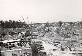 Damage in Beecher, Michigan | |
| Max. rating1 | F5 tornado |
| Casualties | 116 fatalities, 844 injuries |
| 1Most severe tornado damage; see Fujita scale | |
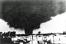
An F5 tornado hit Flint, Michigan on June 8, 1953.[8] The tornado moved east-northeast 2 miles (3.2 km) north of Flushing and devastated the north side of Flint and Beecher. The tornado first descended about 8:30 p.m. on a humid evening near a drive-in movie theater that was flickering to life at twilight time. Motorists in the drive-in began to flee in panic, creating many auto accidents on nearby roads. The tornado dissipated near Lapeer, Michigan. Nearly every home was destroyed on both sides of Coldwater Road. Multiple deaths were reported in 20 families, and it was reported that papers from Flint were deposited in Sarnia, Ontario, Canada, some sixty miles east of Flint. Large sections of neighborhoods were completely swept away, with only foundations left. Trees were debarked and vehicles were thrown and mangled. One hundred and sixteen were killed,[9] making it the tenth deadliest tornado in U.S. history.[10] The death toll was surpassed by the 2011 Joplin tornado.[11] It is also one of only two F5 tornadoes ever to hit in Michigan. Another F5 tornado would hit in Hudsonville on April 3, 1956.[4]
Worcester, Massachusetts
| F4 tornado | |
|---|---|
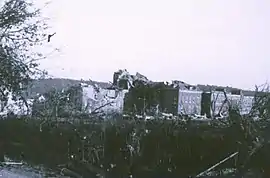 Damage at Assumption College | |
| Max. rating1 | F4 tornado |
| Casualties | 94 fatalities, 1228 injuries |
| 1Most severe tornado damage; see Fujita scale | |
The storm system that created the Flint tornado moved eastward over southern Ontario and Lake Erie during the early morning hours of June 9. As radar was still primitive (or nonexistent) in 1953, inadequate severe weather predictions resulted. (Even during the Super Outbreak of April 3, 1974, weather radar was still not up to this task; that outbreak resulted in a technological upgrade.) The Weather Bureau in Buffalo, New York merely predicted thunderstorms and said that "a tornado may occur." As early as 10 A.M., however, the Weather Bureau in Boston anticipated the likelihood of tornadic conditions that afternoon but feared the word "tornado" would strike panic in the public, and refrained from using it. Instead, as a compromise, they issued New England's first-ever severe thunderstorm watch.[12]
Rain fell across Worcester County throughout the day on June 9.[13] In New York, a strong cluster of thunderstorms began to build, moving eastward into Massachusetts. At approximately 4:25 pm (EST), a funnel cloud formed near the Quabbin Reservoir near New Salem.[14] Very soon after, a tornado spawned from the funnel cloud, touching down in a forest outside of the rural community of Petersham. The tornado then proceeded to pass through a farm field, where it struck a farmhouse and killed two people. As the storm moved eastward at approximately 35 mph (58 km/h), it hit the towns of Rutland and Holden, where 11 people were killed in total.[12](Grazulis, 1993)[4]
At about 5:00 pm, the tornado moved into the city of Worcester, alarming many residents. According to eyewitness accounts, the storm moved in extremely quickly, shocking the townsfolk. "I saw it grow noticeably darker," said eyewitness George Carlson, "Then it hit. Houses tumbled, trees fell, and it was all over. The tornado was definitely discernible. Like when you can see the lines of rain in an approaching rainstorm," he added.[15] The tornado, which had grown to a mile (1.6 km) wide, destroyed several structures in Northern Worcester, including parts of Assumption College. Other major structures included a newly built factory and a large residential development. Residential areas were devastated, where entire rows of homes swept away at possible F5 intensity.[4]
The funnel maintained its 1-mile width as it passed throughout much of Shrewsbury, and still did a high amount of damage when it moved through downtown Westborough, where it began curving towards the northeast in its final leg.[16] In the storm's final moments, 3 were killed when Fayville Post Office in Southborough collapsed.[16] Around the time it ended 5:45 pm, a tornado warning was issued, although by then it was too late.[16]
1953 tornado season in perspective
| State | Total | County | County total |
|---|---|---|---|
| Massachusetts | 90 | Worcester | 90 |
| Michigan | 125 | Genesee | 116 |
| Iosco | 4 | ||
| Monroe | 4 | ||
| Washtenaw | 1 | ||
| Nebraska | 11 | Valley | 11 |
| Ohio | 17 | Cuyahoga | 6 |
| Erie | 2 | ||
| Henry | 5 | ||
| Lorain | 1 | ||
| Wood | 3 | ||
| Totals | 247 | ||
| All deaths were tornado-related | |||
The year 1953 saw some of the deadliest tornadoes in U.S. history, including the Waco Tornado that hit on May 11, the Flint tornado of June 8, and the Worcester tornado on June 9. These 3 storms were also unique in occurring within a 30-day period.
Other severe tornadoes of 1953 hit Warner Robins, Georgia in April, San Angelo, Texas in May (same day as Waco), Port Huron, Michigan later in May, Cleveland in June (same day as Flint and the day before Worcester), and Vicksburg, Mississippi in December.[17]
See also
- List of North American tornadoes and tornado outbreaks
- 2011 New England tornado outbreak, most recent in New England weather history
References
- "Tornado History Project: The Flint - Worcester Outbreak". www.tornadohistoryproject.com. Retrieved 12 October 2020.
- "Storm Events Database - Search Results | National Centers for Environmental Information". www.ncdc.noaa.gov. Retrieved 12 October 2020.
- Schneider, Russell S.; Harold E. Brooks; Joseph T. Schaefer. "Tornado Outbreak Day Sequences: Historic Events and Climatology (1875–2003)" (PDF). Norman, Oklahoma: Storm Prediction Center. Retrieved 13 February 2013.
- Grazulis, Thomas P (July 1993). Significant Tornadoes 1680–1991. St. Johnsbury, VT: The Tornado Project of Environmental Films. ISBN 1-879362-03-1.
- "North America Tornado Cases 1950 to 1959". bangladeshtornadoes.org. Retrieved 16 October 2020.
- "Climatological Data National Summary Publication | IPS | National Climatic Data Center (NCDC)". www.ncdc.noaa.gov. Retrieved 16 October 2020.
- Brooks, Harold E. (April 2004). "On the Relationship of Tornado Path Length and Width to Intensity". Weather and Forecasting. Boston: American Meteorological Society. 19 (2): 310. doi:10.1175/1520-0434(2004)019<0310:OTROTP>2.0.CO;2. Retrieved 11 September 2019.
- "Southeast Michigan Tornado Climatology". National Oceanic and Atmospheric Administration. Retrieved 2007-01-03.
- "1953 Beecher Tornado". National Oceanic and Atmospheric Administration. Retrieved 2007-01-03.
- "The 25 Deadliest U.S. Tornadoes". National Weather Service Storm Prediction Center. Retrieved 24 May 2011.
- "Joplin, Mo., single deadliest tornado since 1950". CBS News.
- O'Toole, John (1993). Tornado! 84 Minutes, 94 Lives. Chandler House Press. Retrieved September 16, 2013.
- Pletcher 2006 p. 155
- Freeman, Stan (June 5, 2011). "Through history, Massachusetts tornadoes not unprecendented, and very deadly". masslive.
- Wheeler, James R. (June 10, 1953). "Randall Street homes grim reminders of death, destruction". Worcester Telegram. Retrieved 1 August 2010.
- Chittick, William F. (2003). The Worcester tornado: June 9, 1953. W.F. Chittick. p. 19.
- "Tornado History Project: 1953". www.tornadohistoryproject.com.
Bibliography
- Chittick, William F. (2003). The Worcester Tornado, June 9, 1953. Bristol, RI: Private Publication.
- Chittick, William F. (2005). What Is So Rare As A Day In June: The Worcester Tornado, June 9, 1953. Bristol, RI: Multimedia Presentation.
- O'Toole, John M. (1993). Tornado! 84 minutes, 94 lives. Worcester: Chandler House Press. ISBN 0-9636277-0-8
Notes
- An outbreak is generally defined as a group of at least six tornadoes (the number sometimes varies slightly according to local climatology) with no more than a six-hour gap between individual tornadoes. An outbreak sequence, prior to (after) modern records that began in 1950, is defined as, at most, two (one) consecutive days without at least one significant (F2 or stronger) tornado.[3]
- All damage totals are in 1953 United States dollars unless otherwise noted.
- All dates are based on the local time zone where the tornado touched down; however, all times are in Coordinated Universal Time and dates are split at midnight CST/CDT for consistency.
- Prior to 1994, only the average widths of tornado paths were officially listed.[7]
External links
- Full map of Flint-Worcester tornado outbreak Tornado History Project
- Video interview of tornado survivor (and nurse) who tended to injured
- Beecher Tornado – Flint Public Library Archive
- Beecher Tornado – Flint Journal Beecher Tornado Anniversary
- 1953 Worcester Tornado Slideshow – City of Worcester
- Worcester Telegram and Gazette site on Worcester tornado
- The Worcester Tornado of 1953
- June 7–9, 1953 — The Flint – Worcester Outbreak (Shawn Schuman)
- Worcester, MA Terrible Tornado Death and Damage, June 1953 at GenDisasters.com
- Flint and Other Towns, MI and OH Tornadoes, June 1953 at GenDisasters.com
- A nurse who attended to victims describes the carnage and scene of the 1953 Flint tornado