Boone County, Iowa
Boone County is a county in the U.S. state of Iowa. As of the 2010 census, the population was 26,306.[1] Its county seat is Boone.[2]
Boone County | |
|---|---|
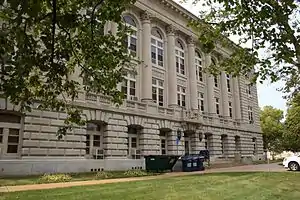 Boone County Courthouse | |
 Seal | |
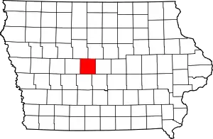 Location within the U.S. state of Iowa | |
 Iowa's location within the U.S. | |
| Coordinates: 42°02′11″N 93°55′56″W | |
| Country | |
| State | |
| Founded | January 13, 1846 |
| Seat | Boone |
| Largest city | Boone |
| Area | |
| • Total | 574 sq mi (1,490 km2) |
| • Land | 572 sq mi (1,480 km2) |
| • Water | 2.1 sq mi (5 km2) 0.4% |
| Population (2010) | |
| • Total | 26,306 |
| • Estimate (2018) | 26,346 |
| • Density | 46/sq mi (18/km2) |
| Time zone | UTC−6 (Central) |
| • Summer (DST) | UTC−5 (CDT) |
| Congressional district | 4th |
Boone County comprises the Boone, IA Micropolitan Statistical Area, which is included in the Des Moines-Ames-West Des Moines, IA Combined Statistical Area.
History
The land that now forms Boone and several other Iowa counties was ceded by the Sac and Fox nation to the United States in a treaty signed on October 11, 1842.
On January 13, 1846, the legislative body of the Indiana Territory authorized creation of twelve counties in the Iowa Territory,[3] with general descriptions of their boundaries.[4] Boone County's name referred to Captain Nathan Boone,[5] son of Daniel Boone, an American pioneer who formed the Wilderness Trail and founded the settlement of Boonesborough, Kentucky.
County residents selected Boonesboro as the county seat in 1851. The first building erected in the new settlement was a double log house, to be used as interim county office and courthouse. It was supplemented by a two–story building erected in 1856, then replaced by a three-story building in 1868.
The nearby settlement of Montana was incorporated in 1866, when a railway station was built there.[6] It was renamed to Boone in 1871.[7] It continued to grow, and it annexed the settlement of Boonesboro (which had also been incorporated in 1866) in 1887, thus becoming the county seat.[7]
After the second courthouse became too small for the county's expanding populace, a new building (the present courthouse) replaced it. It was completed in 1917.[8]
Geography
According to the U.S. Census Bureau, the county has a total area of 574 square miles (1,490 km2), of which 572 square miles (1,480 km2) is land and 2.1 square miles (5.4 km2) (0.4%) is water.[9]
Major highways
.svg.png.webp) U.S. Route 30 – runs east–west through center of county. Passes Beaver, Ogden, and Jordan.
U.S. Route 30 – runs east–west through center of county. Passes Beaver, Ogden, and Jordan..svg.png.webp) U.S. Route 169 – runs south from Webster County through the west-central portion of Boone County. At its intersection with US 30, U.S. 169 runs east three miles to Ogden, then runs south to Dallas County.
U.S. Route 169 – runs south from Webster County through the west-central portion of Boone County. At its intersection with US 30, U.S. 169 runs east three miles to Ogden, then runs south to Dallas County. Iowa Highway 17 – runs south through eastern Boone County to Jordan, west one mile, then south to the boundary line between Dallas and Polk counties.
 Iowa Highway 144 – runs across the southwest tip of the county from northwest to southeast.
 Iowa Highway 210 – enters south line of county at Woodward, then runs east and east-northeast across the southern portion of county to Story County.[10]
Adjacent counties
- Dallas County – south
- Greene County – west
- Hamilton County – north and northeast
- Polk County – south and southeast
- Story County – east
- Webster County – north and northwest
Demographics
| Historical population | |||
|---|---|---|---|
| Census | Pop. | %± | |
| 1850 | 735 | — | |
| 1860 | 4,232 | 475.8% | |
| 1870 | 14,584 | 244.6% | |
| 1880 | 20,838 | 42.9% | |
| 1890 | 23,772 | 14.1% | |
| 1900 | 28,200 | 18.6% | |
| 1910 | 27,626 | −2.0% | |
| 1920 | 29,892 | 8.2% | |
| 1930 | 29,271 | −2.1% | |
| 1940 | 29,782 | 1.7% | |
| 1950 | 28,139 | −5.5% | |
| 1960 | 28,037 | −0.4% | |
| 1970 | 26,470 | −5.6% | |
| 1980 | 26,184 | −1.1% | |
| 1990 | 25,186 | −3.8% | |
| 2000 | 26,224 | 4.1% | |
| 2010 | 26,306 | 0.3% | |
| 2018 (est.) | 26,346 | [11] | 0.2% |
| U.S. Decennial Census[12] 1790-1960[13] 1900-1990[14] 1990-2000[15] 2010-2018[1] | |||
2010 census
The 2010 census recorded a population of 26,306 in the county, with a population density of 46.07/sq mi (17.788/km2). There were 11,756 housing units, of which 10,728 were occupied.[16]
2000 census
As of the census[17] of 2000, there were 26,224 people, 10,374 households, and 7,137 families residing in the county. The population density was 46 people per square mile (18/km2). There were 10,968 housing units at an average density of 19 per square mile (7/km2). The racial makeup of the county was 98.53% White, 0.36% Black or African American, 0.20% Native American, 0.22% Asian, 0.26% from other races, and 0.43% from two or more races. 0.83% of the population were Hispanic or Latino of any race.
There were 10,374 households, out of which 31.20% had children under the age of 18 living with them, 58.00% were married couples living together, 7.80% had a female householder with no husband present, and 31.20% were non-families. 26.70% of all households were made up of individuals, and 11.80% had someone living alone who was 65 years of age or older. The average household size was 2.44 and the average family size was 2.95.
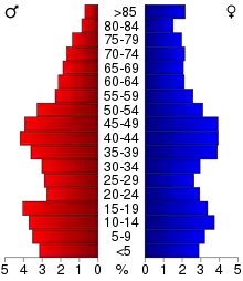
In the county, the population was spread out, with 24.80% under the age of 18, 8.40% from 18 to 24, 27.10% from 25 to 44, 23.30% from 45 to 64, and 16.40% who were 65 years of age or older. The median age was 39 years. For every 100 females there were 95.90 males. For every 100 females age 18 and over, there were 91.70 males.
The median income for a household in the county was $40,763, and the median income for a family was $49,346. Males had a median income of $32,504 versus $23,838 for females. The per capita income for the county was $19,943. About 4.50% of families and 7.60% of the population were below the poverty line, including 8.00% of those under age 18 and 5.90% of those age 65 or over.
Communities
Cities
Townships
Population ranking
The population ranking of the following table is based on the 2010 census of Boone County.[18]
† county seat
| Rank | City/Town/etc. | Municipal type | Population (2010 Census) |
|---|---|---|---|
| 1 | † Boone | City | 12,661 |
| 2 | Madrid | City | 2,543 |
| 3 | Ogden | City | 2,044 |
| 4 | Boxholm | City | 195 |
| 5 | Pilot Mound | City | 173 |
| 6 | Luther | City | 122 |
| 7 | Fraser | City | 102 |
| 8 | Beaver | City | 48 |
| 9 | Berkley | City | 32 |
| 10 | Sheldahl (partially in Polk and Story Counties) | City | 19 (319 total) |
Politics
Prior to 1932, Boone County was primarily Republican in presidential elections, aside from 1912 when the county backed Bull Moose candidate & former Republican President Theodore Roosevelt. From 1932 to 1980, the county was a swing county, voting for the national winner in all elections in that period aside from 1960. From 1984 to 2012, the county was consistently Democratic in presidential elections, but swung hard in 2016 by 20.7 points to back Republican Donald Trump similar to many other counties in Iowa.[19]
| Year | Republican | Democratic | Third parties |
|---|---|---|---|
| 2016 | 52.7% 7,484 | 39.0% 5,541 | 8.3% 1,171 |
| 2012 | 45.6% 6,556 | 52.2% 7,512 | 2.2% 320 |
| 2008 | 45.2% 6,293 | 52.8% 7,356 | 2.0% 282 |
| 2004 | 49.0% 6,870 | 50.2% 7,027 | 0.8% 112 |
| 2000 | 45.9% 5,625 | 51.2% 6,270 | 2.9% 354 |
| 1996 | 36.3% 4,293 | 54.5% 6,446 | 9.3% 1,096 |
| 1992 | 34.0% 4,148 | 48.4% 5,913 | 17.7% 2,158 |
| 1988 | 37.5% 4,381 | 61.9% 7,232 | 0.6% 73 |
| 1984 | 46.8% 5,746 | 52.8% 6,485 | 0.4% 46 |
| 1980 | 47.4% 5,732 | 42.4% 5,126 | 10.2% 1,229 |
| 1976 | 44.1% 5,413 | 53.8% 6,595 | 2.1% 255 |
| 1972 | 54.3% 6,271 | 43.8% 5,057 | 1.9% 223 |
| 1968 | 47.4% 5,260 | 47.0% 5,219 | 5.6% 617 |
| 1964 | 31.3% 3,543 | 67.9% 7,699 | 0.8% 93 |
| 1960 | 54.0% 6,761 | 46.0% 5,759 | 0.1% 7 |
| 1956 | 53.7% 6,740 | 46.3% 5,815 | 0.1% 9 |
| 1952 | 61.0% 7,901 | 37.8% 4,896 | 1.2% 150 |
| 1948 | 40.9% 4,183 | 54.2% 5,541 | 4.9% 498 |
| 1944 | 44.2% 4,868 | 55.1% 6,062 | 0.7% 73 |
| 1940 | 41.9% 5,227 | 57.5% 7,168 | 0.6% 74 |
| 1936 | 35.3% 4,110 | 60.9% 7,080 | 3.8% 439 |
| 1932 | 38.0% 3,694 | 54.4% 5,293 | 7.6% 735 |
| 1928 | 70.0% 7,521 | 28.4% 3,049 | 1.6% 172 |
| 1924 | 45.6% 4,980 | 6.4% 702 | 48.0% 5,246[21] |
| 1920 | 71.1% 7,093 | 22.4% 2,240 | 6.5% 647 |
| 1916 | 52.4% 2,955 | 41.5% 2,338 | 6.1% 345 |
| 1912 | 13.6% 802 | 27.2% 1,601 | 59.1% 3,477 |
| 1908 | 57.7% 3,368 | 33.6% 1,958 | 8.7% 510 |
| 1904 | 65.7% 3,830 | 19.7% 1,148 | 14.7% 855 |
| 1900 | 61.6% 4,151 | 33.6% 2,264 | 4.8% 326 |
| 1896 | 56.4% 3,741 | 42.3% 2,801 | 1.3% 88 |
See also
References
- "State & County QuickFacts". United States Census Bureau. Archived from the original on January 3, 2016. Retrieved July 13, 2014.
- "Find a County". National Association of Counties. Archived from the original on May 31, 2011. Retrieved June 7, 2011.
- The counties were Boone, Clarke, Dallas, Decatur, Jasper, Lucas, Madison, Marshall, Polk, Story, Warren, and Wayne.
- The History of Polk County, Iowa: Containing a History of the County, Its Cities, Towns, &c. Union Historical Co. 1880. pp. 419, 425.
- History of the Origin of the Place Names in Nine Northwestern States. 1908. p. 12.
- "Bird's eye view of the city of Montana, Boone Co. IA". historymap.com. Retrieved August 20, 2018.
- "County History". Boone County IA. Retrieved August 20, 2018.
- "Boone County Courthouse". Iowa Judicial Branch. Retrieved August 20, 2018.
- "US Gazetteer files: 2010, 2000, and 1990". United States Census Bureau. February 12, 2011. Retrieved April 23, 2011.
- Boone County IA Google Maps (accessed August 20, 2018)
- "Population and Housing Unit Estimates". Retrieved June 20, 2019.
- "U.S. Decennial Census". US Census Bureau. Retrieved July 13, 2014.
- "Historical Census Browser". University of Virginia Library. Retrieved July 13, 2014.
- "Population of Counties by Decennial Census: 1900 to 1990". US Census Bureau. Retrieved July 13, 2014.
- "Census 2000 PHC-T-4. Ranking Tables for Counties: 1990 and 2000" (PDF). US Census Bureau. Retrieved July 13, 2014.
- "Population and Housing Occupancy Status: 2010 - State -- County". US Census Bureau – American FactFinder. Retrieved March 8, 2011.
- "U.S. Census website". US Census Bureau. Retrieved January 31, 2008.
- "Archived copy". Retrieved May 25, 2015.
- "Here's a map of the US counties that flipped to Trump from Democrats". www.cnbc.com. Retrieved February 18, 2019.
- Leip, David. "Dave Leip's Atlas of U.S. Presidential Elections". uselectionatlas.org. Retrieved April 25, 2018.
- The leading "other" candidate, Progressive Robert M. La Follette, received 4,953 votes, while Communist Party candidate William Z. Foster received 286 votes, and Write-in candidates 7 votes.
External links
| Wikimedia Commons has media related to Boone County, Iowa. |
- Boone County on state government portal
- Boone County government's website
- Boone County Republican, Google news archive. —PDFs of 1,242 issues, dating from 1873 to 1897.
Places adjacent to Boone County, Iowa | ||||||||||
|---|---|---|---|---|---|---|---|---|---|---|
| ||||||||||
Municipalities and communities of Boone County, Iowa, United States | ||
|---|---|---|
| Cities | Map of Iowa highlighting Boone County | |
| Townships | ||
| Unincorporated communities | ||
| Ghost town | ||
| Footnotes | ‡This populated place also has portions in an adjacent county or counties | |
| ||

| Authority control |
|---|