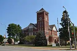
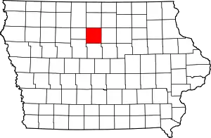
Wright County, Iowa
Wright County is a county in the U.S. state of Iowa. As of the 2010 census, the population was 13,229.[1] The county seat is Clarion.[2] The county organization became effective in January 1851, and is believed to be named either after Silas Wright, a governor of New York, or Joseph Albert Wright, a governor of Indiana.[3]
Wright County | |
|---|---|
 | |
 Location within the U.S. state of Iowa | |
 Iowa's location within the U.S. | |
| Coordinates: 42°43′59″N 93°44′08″W | |
| Country | |
| State | |
| Founded | January 15, 1851 |
| Named for | Silas Wright |
| Seat | Clarion |
| Largest city | Eagle Grove |
| Area | |
| • Total | 582 sq mi (1,510 km2) |
| • Land | 580 sq mi (1,500 km2) |
| • Water | 1.8 sq mi (5 km2) 0.3% |
| Population (2010) | |
| • Total | 13,229 |
| • Estimate (2018) | 12,690 |
| • Density | 23/sq mi (8.8/km2) |
| Time zone | UTC−6 (Central) |
| • Summer (DST) | UTC−5 (CDT) |
| Congressional district | 4th |
Geography
According to the U.S. Census Bureau, the county has an area of 582 square miles (1,510 km2), of which 580 square miles (1,500 km2) is land and 1.8 square miles (4.7 km2) (0.3%) is covered by water.[4] The terrain is generally undulating. The county is intersected by the Boone and Iowa Rivers[5]
Major highways
 Interstate 35
 U.S. Highway 69
 Iowa Highway 3
 Iowa Highway 17
Adjacent counties
- Hancock County - north
- Franklin County - east
- Hardin County - southeast
- Hamilton County - south
- Webster County - southwest
- Humboldt County - west
Demographics
| Historical population | |||
|---|---|---|---|
| Census | Pop. | %± | |
| 1870 | 2,392 | — | |
| 1880 | 5,062 | 111.6% | |
| 1890 | 12,057 | 138.2% | |
| 1900 | 18,227 | 51.2% | |
| 1910 | 17,951 | −1.5% | |
| 1920 | 20,348 | 13.4% | |
| 1930 | 20,216 | −0.6% | |
| 1940 | 20,038 | −0.9% | |
| 1950 | 19,652 | −1.9% | |
| 1960 | 19,447 | −1.0% | |
| 1970 | 17,294 | −11.1% | |
| 1980 | 16,319 | −5.6% | |
| 1990 | 14,269 | −12.6% | |
| 2000 | 14,334 | 0.5% | |
| 2010 | 13,229 | −7.7% | |
| 2018 (est.) | 12,690 | [6] | −4.1% |
| U.S. Decennial Census[7] 1790-1960[8] 1900-1990[9] 1990-2000[10] 2010-2018[1] | |||
2010 census
The 2010 census recorded a population of 13,229 in the county, with a population density of 22.7803/sq mi (8.7955/km2). There were 6,529 housing units, of which 5,625 were occupied.[11]
2000 census
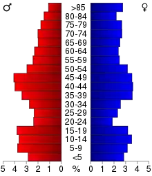
As of the census[12] of 2000, there were 14,334 people, 5,940 households, and 3,938 families residing in the county. The population density was 25 people per square mile (10/km2). There were 6,559 housing units at an average density of 11 per square mile (4/km2). The racial makeup of the county was 95.93% White, 0.17% Black or African American, 0.18% Native American, 0.20% Asian, 2.90% from other races, and 0.63% from two or more races. 4.93% of the population were Hispanic or Latino of any race.
There were 5,940 households, out of which 28.40% had children under the age of 18 living with them, 57.30% were married couples living together, 6.20% had a female householder with no husband present, and 33.70% were non-families. 30.20% of all households were made up of individuals, and 16.30% had someone living alone who was 65 years of age or older. The average household size was 2.36 and the average family size was 2.92.
In the county, the population was spread out, with 24.50% under the age of 18, 6.50% from 18 to 24, 24.50% from 25 to 44, 23.30% from 45 to 64, and 21.20% who were 65 years of age or older. The median age was 41 years. For every 100 females there were 96.20 males. For every 100 females age 18 and over, there were 92.30 males.
The median income for a household in the county was $36,197, and the median income for a family was $44,043. Males had a median income of $29,398 versus $21,222 for females. The per capita income for the county was $18,247. About 4.20% of families and 7.00% of the population were below the poverty line, including 7.70% of those under age 18 and 6.40% of those age 65 or over.
Education
Primary and secondary
There are three school districts in Wright County with three high schools: Clarion-Goldfield-Dows Community School District K-12 Enrollment 954 Eagle Grove Community School District K-12 Enrollment 836 Belmond-Klemme Community School District K-12 Enrollment 793
Tertiary
Iowa State University maintains an extension office in Clarion. Iowa Central Community College in Fort Dodge, North Iowa Area Community College in Mason City, and Ellsworth Community College in Iowa Falls are all within driving distance of Wright County. Iowa Central Community College began offering ICN Polycom classes in Clarion and Eagle Grove in 2015.
Politics
Wright County has, like many counties in Iowa, been a swing state for the majority of its history. The county has voted for the winning candidate in 21 out of the 25 presidential elections in the 20th Century. However in 2000, the county was won by Republican George W. Bush and has voted for the party in all presidential elections since.
| Year | Republican | Democratic | Third Parties |
|---|---|---|---|
| 2016 | 63.1% 3,800 | 31.5% 1,896 | 5.5% 330 |
| 2012 | 53.4% 3,349 | 45.2% 2,836 | 1.5% 93 |
| 2008 | 50.0% 3,198 | 48.5% 3,102 | 1.5% 95 |
| 2004 | 55.0% 3,631 | 44.4% 2,930 | 0.6% 42 |
| 2000 | 53.4% 3,384 | 44.1% 2,796 | 2.5% 156 |
| 1996 | 41.5% 2,473 | 48.9% 2,912 | 9.6% 574 |
| 1992 | 40.6% 2,708 | 41.7% 2,776 | 17.7% 1,181 |
| 1988 | 43.9% 2,658 | 55.4% 3,353 | 0.7% 43 |
| 1984 | 54.8% 3,675 | 44.4% 2,980 | 0.8% 50 |
| 1980 | 55.1% 3,936 | 37.0% 2,645 | 7.9% 566 |
| 1976 | 48.7% 3,544 | 50.0% 3,637 | 1.4% 101 |
| 1972 | 59.7% 4,278 | 38.8% 2,780 | 1.5% 104 |
| 1968 | 57.0% 4,299 | 39.3% 2,969 | 3.7% 281 |
| 1964 | 36.1% 2,831 | 63.8% 4,998 | 0.1% 7 |
| 1960 | 56.3% 5,386 | 43.5% 4,159 | 0.2% 15 |
| 1956 | 58.7% 5,512 | 41.2% 3,865 | 0.1% 13 |
| 1952 | 67.1% 6,566 | 32.6% 3,186 | 0.3% 31 |
| 1948 | 48.9% 3,810 | 49.6% 3,866 | 1.6% 124 |
| 1944 | 47.9% 3,916 | 51.7% 4,232 | 0.4% 35 |
| 1940 | 47.5% 4,443 | 52.1% 4,871 | 0.4% 36 |
| 1936 | 38.0% 3,311 | 59.4% 5,177 | 2.6% 222 |
| 1932 | 39.1% 3,262 | 59.1% 4,922 | 1.8% 150 |
| 1928 | 65.8% 5,020 | 33.4% 2,547 | 0.8% 63 |
| 1924 | 57.4% 4,323 | 6.7% 501 | 35.9% 2,707 |
| 1920 | 81.0% 5,739 | 17.0% 1,205 | 2.0% 138 |
| 1916 | 68.2% 2,599 | 29.8% 1,135 | 2.0% 76 |
| 1912 | 22.6% 805 | 21.5% 765 | 55.8% 1,985 |
| 1908 | 72.3% 2,498 | 25.1% 866 | 2.6% 89 |
| 1904 | 77.4% 2,795 | 19.2% 695 | 3.4% 122 |
| 1900 | 75.1% 2,990 | 22.4% 891 | 2.6% 102 |
| 1896 | 71.4% 2,992 | 27.2% 1,138 | 1.5% 61 |
Media
Several small newspapers are published in Wright County, including the Wright County Monitor, serving Clarion and Dows, the Eagle Grove Eagle, and the Belmond Independent.
Wright County Fair
The first Wright County Fair was held in Clarion. The old fairgrounds were located where Clarion's USA Healthcare Center stands today. the Clarion Fair ran until 1924; it was held in Goldfield in 1925, and moved to its present location in Eagle Grove in 1926; it was later retitled as the Wright County District Junior Fair. Entries are open to children in Hamilton, Humboldt, Webster, Hardin, Franklin, and Wright Counties.[14]
Communities
Unincorporated communities
Townships
Population ranking
The population ranking of the following table is based on the 2010 census of Wright County.[15]
† county seat
| Rank | City/Town/etc. | Municipal type | Population (2010 Census) |
|---|---|---|---|
| 1 | Eagle Grove | City | 3,583 |
| 2 | † Clarion | City | 2,850 |
| 3 | Belmond | City | 2,376 |
| 4 | Goldfield | City | 635 |
| 5 | Dows (partially in Franklin County) | City | 538 |
| 6 | Woolstock | City | 168 |
| 7 | Rowan | City | 158 |
| 8 | Galt | City | 32 |
See also
References
- "State & County QuickFacts". United States Census Bureau. Retrieved July 20, 2014.
- "Find a County". National Association of Counties. Retrieved June 7, 2011.
- Wright County Archived 2007-10-04 at the Wayback Machine
- "US Gazetteer files: 2010, 2000, and 1990". United States Census Bureau. February 12, 2011. Retrieved April 23, 2011.
- Ripley, George; Dana, Charles A., eds. (1879). . The American Cyclopædia.
- "Population and Housing Unit Estimates". Retrieved June 27, 2019.
- "U.S. Decennial Census". United States Census Bureau. Retrieved July 20, 2014.
- "Historical Census Browser". University of Virginia Library. Retrieved July 20, 2014.
- "Population of Counties by Decennial Census: 1900 to 1990". United States Census Bureau. Retrieved July 20, 2014.
- "Census 2000 PHC-T-4. Ranking Tables for Counties: 1990 and 2000" (PDF). United States Census Bureau. Retrieved July 20, 2014.
- "Population & Housing Occupancy Status 2010". United States Census Bureau American FactFinder. Retrieved June 19, 2011.
- "U.S. Census website". United States Census Bureau. Retrieved January 31, 2008.
- Leip, David. "Dave Leip's Atlas of U.S. Presidential Elections". uselectionatlas.org. Retrieved April 28, 2018.
- Wright County District Junior Fair
- 2010 Census
External links
| Wikimedia Commons has media related to Wright County, Iowa. |
Places adjacent to Wright County, Iowa | ||||||||||
|---|---|---|---|---|---|---|---|---|---|---|
| ||||||||||
Municipalities and communities of Wright County, Iowa, United States | ||
|---|---|---|
| Cities | Map of Iowa highlighting Wright County | |
| Towns | ||
| Unincorporated communities | ||
| Ghost town | ||
| Footnotes | ‡This populated place also has portions in an adjacent county or counties | |
| ||

| Authority control |
|---|