List of Gram Panchayats in Malappuram district
Malappuram is one of the 14 districts in the southern Indian state of Kerala. Kerala, with appreciative development indicators comparable to developed countries, has been experimenting with decentralization and participatory local democracy, ultimately aimed at the realization of the constitutional goal of establishing genuine "institutions of local self-government" since the enactment of Kerala Panchayat Raj Act & The Kerala Municipality Act in the year 1994. Gram Panchayats are the basic units of rural governance in the decentralized system.[1]
| Gram Panchayats of Malappuram | |
|---|---|
 Local Self Government Institutions in the district | |
| Category | Gram Panchayats |
| Location | Malappuram district |
| Number | 94 Gram Panchayats |
| Government | Government of Kerala |
| Subdivisions | Block Panchayats |
Overview
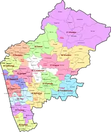
Malappuram is the most populous and the third-largest district in the state.[2] The rural district is divided into 94 Gram Panchayats which are included in 15 blocks namely Areekode, Kalikavu, Kondotty, Kuttipuram, Malappuram, Mankada, Nilambur, Perinthalmanna, Perumpadappu, Ponnani, Tanur, Tirur, Tirurangadi, Vengara, and Wandoor.[3] These blocks combine to form the Malappuram district Panchayat, which is the apex district body of rural governance. Malappuram District Panchayat is the largest District Panchayat as well as the largest local self-government body in the state. The 94 Gram Panchayats are again divided into 1,778 wards.[4] Census towns (small towns with urban features) also come under the jurisdiction of Gram Panchayats. Though the draft notifications for the formation of new Gram Panchayats namely Anamangad, Ananthavoor, Arakkuparamba, Ariyallur, Chembrassery, Elankur, Karipur, Kootayi, Kurumbalangode, Marutha, Pang, Vaniyambalam, and Velimukku were published in 2015, they are yet to be formed.[5] With their formation, the number of Gram Panchayats in the district will become 106.
List of Gram Panchayats in the district
| Gram Panchayat | Area (in km2) |
Population (2011) |
Wards | Taluk | |
|---|---|---|---|---|---|
| Areekode Block | |||||
| 1 | Areekode | 12.21 | 31,563 | 18 | Eranad |
| 2 | Cheekkode | 23.96 | 32,867 | 18 | Kondotty |
| 3 | Edavanna | 52.10 | 46,128 | 22 | Eranad |
| 4 | Kavanoor | 31.30 | 37,977 | 19 | Eranad |
| 5 | Kizhuparamba | 14.99 | 22,062 | 14 | Eranad |
| 6 | Kuzhimanna | 22.05 | 34,413 | 18 | Kondotty |
| 7 | Pulpatta | 30.12 | 42,683 | 21 | Eranad |
| 8 | Urangattiri | 76.09 | 40,318 | 21 | Eranad |
| Kalikavu Block | |||||
| 9 | Amarambalam | 84.64 | 35,975 | 19 | Nilambur |
| 10 | Chokkad | 76.08 | 32,224 | 18 | Nilambur |
| 11 | Edappatta | 25.77 | 22,729 | 15 | Perinthalmanna |
| 12 | Kalikavu | 92.00 | 35,210 | 19 | Nilambur |
| 13 | Karulai | 131.31 | 23,277 | 15 | Nilambur |
| 14 | Karuvarakundu | 78.69 | 41,583 | 21 | Nilambur |
| 15 | Tuvvur | 31.38 | 40,297 | 17 | Nilambur |
| Kondotty Block | |||||
| 16 | Chelembra | 15.91 | 34,149 | 18 | Kondotty |
| 17 | Cherukavu | 16.87 | 36,773 | 19 | Kondotty |
| 18 | Muthuvallur | 21.49 | 26,028 | 15 | Kondotty |
| 19 | Pallikkal | 25.96 | 46,962 | 22 | Kondotty |
| 20 | Pulikkal | 28.70 | 40,133 | 21 | Kondotty |
| 21 | Vazhayur | 21.19 | 30,262 | 17 | Kondotty |
| 22 | Vazhakkad | 23.89 | 35,774 | 19 | Kondotty |
| Kuttippuram Block | |||||
| 23 | Athavanad | 26.77 | 41,187 | 22 | Tirur |
| 24 | Edayur | 30.43 | 36,498 | 19 | Tirur |
| 25 | Irimbiliyam | 24.06 | 30,635 | 17 | Tirur |
| 26 | Kalpakanchery | 16.25 | 33,721 | 19 | Tirur |
| 27 | Kuttippuram | 31.32 | 47,023 | 23 | Tirur |
| 28 | Marakkara | 27.00 | 40,404 | 20 | Tirur |
| Malappuram Block | |||||
| 29 | Anakkayam | 45.23 | 50,634 | 23 | Eranad |
| 30 | Kodur | 18.42 | 38,258 | 19 | Perinthalmanna |
| 31 | Morayur | 24.57 | 25,261 | 18 | Kondotty |
| 32 | Othukkungal | 17.28 | 39,139 | 20 | Tirurangadi |
| 33 | Ponmala | 21.65 | 33,922 | 18 | Tirur |
| 34 | Pookkottur | 20.63 | 28,077 | 19 | Eranad |
| Mankada Block | |||||
| 35 | Koottilangadi | 21.54 | 36,602 | 19 | Perinthalmanna |
| 36 | Kuruva | 35.77 | 45,354 | 22 | Perinthalmanna |
| 37 | Makkaraparamba | 11.17 | 18,702 | 13 | Perinthalmanna |
| 38 | Mankada | 31.00 | 32,748 | 18 | Perinthalmanna |
| 39 | Moorkanad | 17.60 | 36,324 | 19 | Perinthalmanna |
| 40 | Puzhakkattiri | 22.72 | 29,886 | 17 | Perinthalmanna |
| Nilambur Block | |||||
| 41 | Chaliyar | 125.00 | 20,834 | 14 | Nilambur |
| 42 | Chungathara | 129.69 | 36,269 | 20 | Nilambur |
| 43 | Edakkara | 58.09 | 28,162 | 16 | Nilambur |
| 44 | Moothedam | 48.00 | 33,960 | 15 | Nilambur |
| 45 | Pothukal | 77.00 | 29,561 | 17 | Nilambur |
| 46 | Vazhikkadavu | 114.00 | 47,322 | 23 | Nilambur |
| Perinthalmanna Block | |||||
| 47 | Aliparamba | 34.37 | 41,725 | 21 | Perinthalmanna |
| 48 | Angadipuram | 38.50 | 56,451 | 23 | Perinthalmanna |
| 49 | Elamkulam | 21.31 | 26,456 | 16 | Perinthalmanna |
| 50 | Keezhattur | 40.00 | 36,317 | 19 | Perinthalmanna |
| 51 | Melattur | 27.24 | 27,250 | 16 | Perinthalmanna |
| 52 | Pulamantol | 32.15 | 37,785 | 20 | Perinthalmanna |
| 53 | Thazhekode | 24.03 | 41,982 | 21 | Perinthalmanna |
| 54 | Vettathur | 35.84 | 37,456 | 16 | Perinthalmanna |
| Perumpadappu Block | |||||
| 55 | Alamkode | 20.50 | 33,918 | 19 | Ponnani |
| 56 | Maranchery | 20.47 | 35,011 | 19 | Ponnani |
| 57 | Nannamukku | 19.35 | 28,989 | 17 | Ponnani |
| 58 | Perumpadappu | 15.02 | 29,766 | 18 | Ponnani |
| 59 | Veliyankode | 15.15 | 32,554 | 18 | Ponnani |
| Ponnani Block | |||||
| 60 | Edappal | 23.70 | 32,550 | 19 | Ponnani |
| 61 | Vattamkulam | 20.73 | 36,147 | 19 | Ponnani |
| 62 | Thavanur | 25.28 | 34,500 | 19 | Ponnani |
| 63 | Kalady | 16.48 | 25,872 | 16 | Ponnani |
| Tanur Block | |||||
| 64 | Cheriyamundam | 11.95 | 31,212 | 18 | Tirur |
| 65 | Niramaruthur | 9.20 | 29,846 | 17 | Tirur |
| 66 | Ozhur | 15.92 | 34,016 | 18 | Tirur |
| 67 | Perumanna-Klari | 11.48 | 27,278 | 16 | Tirur |
| 68 | Ponmundam | 9.16 | 25,855 | 16 | Tirur |
| 69 | Tanalur | 15.12 | 47,976 | 23 | Tirur |
| 70 | Valavannur | 15.28 | 33,159 | 19 | Tirur |
| Tirur Block | |||||
| 71 | Purathur | 19.50 | 31,915 | 19 | Tirur |
| 72 | Thalakkad | 16.30 | 35,820 | 19 | Tirur |
| 73 | Tirunavaya | 19.59 | 45,848 | 23 | Tirur |
| 74 | Triprangode | 20.67 | 41,167 | 21 | Tirur |
| 75 | Vettom | 13.46 | 28,104 | 20 | Tirur |
| 76 | Mangalam | 12.17 | 33,442 | 20 | Tirur |
| Tirurangadi Block | |||||
| 77 | Moonniyur | 22.66 | 55,535 | 23 | Tirurangadi |
| 78 | Nannambra | 18.35 | 40,543 | 21 | Tirurangadi |
| 79 | Vallikkunnu | 25.14 | 48,006 | 23 | Tirurangadi |
| 80 | Thenhipalam | 17.98 | 32,045 | 17 | Tirurangadi |
| 81 | Peruvallur | 21.19 | 34,941 | 19 | Tirurangadi |
| Vengara Block | |||||
| 82 | Abdu Rahiman Nagar | 14.83 | 41,993 | 21 | Tirurangadi |
| 83 | Edarikode | 15.65 | 27,356 | 16 | Tirurangadi |
| 84 | Kannamangalam | 28.24 | 41,260 | 20 | Tirurangadi |
| 85 | Oorakam | 21.65 | 29,157 | 17 | Tirurangadi |
| 86 | Parappur | 18.50 | 36,270 | 19 | Tirurangadi |
| 87 | Thennala | 10.00 | 29,190 | 17 | Tirurangadi |
| 88 | Vengara | 18.66 | 48,600 | 23 | Tirurangadi |
| Wandoor Block | |||||
| 89 | Mampad | 84.67 | 37,221 | 19 | Nilambur |
| 90 | Pandikkad | 57.01 | 55,213 | 23 | Eranad |
| 91 | Porur | 35.60 | 37,636 | 17 | Nilambur |
| 92 | Thiruvali | 33.83 | 27,734 | 16 | Nilambur |
| 93 | Trikkalangode | 59.99 | 52,090 | 23 | Eranad |
| 94 | Wandoor | 45.45 | 49,013 | 23 | Nilambur |
| Sources: 2011 Census of India,[6] Government of Kerala[7] | |||||
References
- "Panchayati Raj System in India | Definition, Examples, Diagrams". www.toppr.com. Retrieved 4 December 2020.
- "Population profile of Kerala". spb.kerala.gov.in.
- "Rural administration in Malappuram district". Official website of Malappuram district. Retrieved 2 August 2020.
- "Gram Panchayats and wards in Malappuram". Local self-government department, Government of Kerala. Retrieved 3 August 2020.
- "Draft notifications for new local bodies in Malappuram". Delimitation Commission, Kerala. Government of Kerala. Retrieved 10 October 2020.
- "Taluk-wise demography of Malappuram" (PDF). censusindia.gov.in. Directorate of Census Operations, Kerala. pp. 161–193. Retrieved 19 April 2020.
- "Villages in Malappuram". lsgkerala.gov.in. Retrieved 2 August 2020.
- "dchb malappuram" (PDF). censusindia.gov.in.