Los Pinos River
Los Pinos River is a tributary of the San Juan River in southern Colorado and northern New Mexico in the United States. The stream flows from a source near Weminuche Pass in the San Juan Mountains of Colorado to a confluence with the San Juan River at Navajo Lake in San Juan County, New Mexico.
| Los Pinos River[1] Pine River | |
|---|---|
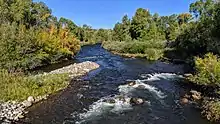
 The river near the intersection of County roads 501 and 245 | |
| Physical characteristics | |
| Source | |
| • location | Hinsdale County, Colorado |
| • coordinates | 37°40′39″N 107°19′09″W |
| Mouth | |
• location | Confluence with San Juan River |
• coordinates | 36°49′15″N 107°36′06″W |
• elevation | 6,089 ft (1,856 m) |
| Basin features | |
| Progression | San Juan—Colorado |
The river is impounded by the Vallecito Dam.
The name Los Pinos is Spanish for "the pines,"[2] and, in fact, the river is known locally as the Pine River.[3]
Los Pinos River looking north, at business 160 in Bayfield, Colorado

Los Pinos River looking south, at business 160 in Bayfield, Colorado
References
- "Los Pinos River". Geographic Names Information System. United States Geological Survey. Retrieved 2013-05-15.
- Gannett, Henry (1905). The Origin of Certain Place Names in the United States. U.S. Government Printing Office. p. 190.,
- Duranglers Flies and Supplies. Los Pinos River Viewed 2016-03-18.
External links

Santa Fe (capital) | ||
| Topics |
| |
| Society | ||
| Regions |
| |
| Cities | ||
| Counties | ||

| Authority control |
|
|---|
This article is issued from Wikipedia. The text is licensed under Creative Commons - Attribution - Sharealike. Additional terms may apply for the media files.