National Register of Historic Places listings in Braxton County, West Virginia
This is a list of the National Register of Historic Places listings in Braxton County, West Virginia.
This is intended to be a complete list of the properties and districts on the National Register of Historic Places in Braxton County, West Virginia, United States. The locations of National Register properties and districts for which the latitude and longitude coordinates are included below, may be seen in a Google map.[1]
There are 10 properties and districts listed on the National Register in the county.
- This National Park Service list is complete through NPS recent listings posted February 5, 2021.[2]
Barbour - Berkeley - Boone - Braxton - Brooke - Cabell - Calhoun - Clay - Doddridge - Fayette - Gilmer - Grant - Greenbrier - Hampshire - Hancock - Hardy - Harrison - Jackson - Jefferson - Kanawha - Lewis - Lincoln - Logan - Marion - Marshall - Mason - McDowell - Mercer - Mineral - Mingo - Monongalia - Monroe - Morgan - Nicholas - Ohio - Pendleton - Pleasants - Pocahontas - Preston - Putnam - Raleigh - Randolph - Ritchie - Roane - Summers - Taylor - Tucker - Tyler - Upshur - Wayne - Webster - Wetzel - Wirt - Wood - Wyoming |
Current listings
| [3] | Name on the Register[4] | Image | Date listed[5] | Location | City or town | Description |
|---|---|---|---|---|---|---|
| 1 | Burnsville Bridge | 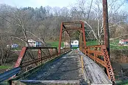 Burnsville Bridge |
March 17, 1995 (#95000254) |
Bridge St. over the Little Kanawha River 38°51′19″N 80°39′25″W |
Burnsville | |
| 2 | Cunningham House and Outbuildings | 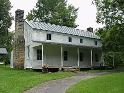 Cunningham House and Outbuildings |
March 21, 1984 (#84003510) |
Bulltown Historic Area at Burnsville Lake[6] 38°47′34″N 80°33′40″W |
Napier | |
| 3 | Gassaway Depot |  Gassaway Depot |
March 17, 1994 (#94000215) |
Between 4th and 5th Sts. 38°40′16″N 80°46′36″W |
Gassaway | |
| 4 | William Edgar Haymond House |  William Edgar Haymond House |
April 21, 2004 (#04000356) |
110 S. Stonewall St. 38°39′45″N 80°42′33″W |
Sutton | |
| 5 | Old Sutton High School |  Old Sutton High School |
August 29, 1979 (#79002570) |
N. Hill Rd. 38°40′00″N 80°42′26″W |
Sutton | |
| 6 | Michael Smith House | September 28, 2006 (#06000902) |
End of County Route 5/1, 1 mi (1.6 km) from its junction with County Route 19/26 38°48′39″N 80°48′04″W |
Cedarville | ||
| 7 | Sutton Downtown Historic District | 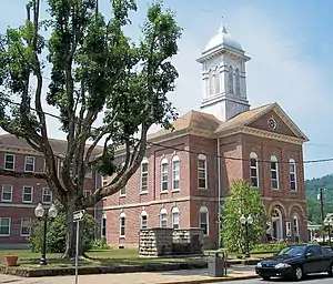 Sutton Downtown Historic District |
July 10, 1987 (#87001059) |
Roughly bounded by Main St., River View Dr., and First St. 38°39′51″N 80°42′28″W |
Sutton | |
| 8 | Union Civil War Fortification | March 21, 1984 (#84003515) |
Bulltown Historic Area at Burnsville Lake[6] 38°47′23″N 80°33′51″W |
Napier | ||
| 9 | Weston and Gauley Bridge Turnpike | 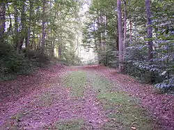 Weston and Gauley Bridge Turnpike |
January 28, 1999 (#98001430) |
Section between Stonewell Jackson Lake and Burnsville Lake 38°49′39″N 80°32′07″W |
Burnsville | |
| 10 | Windy Run Grade School | 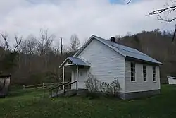 Windy Run Grade School |
January 12, 1984 (#84003518) |
Junction of CR 38 and CR 19/48 38°35′57″N 80°43′27″W |
Tesla |
See also
| Wikimedia Commons has media related to National Register of Historic Places in Braxton County, West Virginia. |
References
- The latitude and longitude information provided in this table was derived originally from the National Register Information System, which has been found to be fairly accurate for about 99% of listings. Some locations in this table may have been corrected to current GPS standards.
- "National Register of Historic Places: Weekly List Actions". National Park Service, United States Department of the Interior. Retrieved on February 5, 2021.
- Numbers represent an alphabetical ordering by significant words. Various colorings, defined here, differentiate National Historic Landmarks and historic districts from other NRHP buildings, structures, sites or objects.
- "National Register Information System". National Register of Historic Places. National Park Service. April 24, 2008.
- The eight-digit number below each date is the number assigned to each location in the National Register Information System database, which can be viewed by clicking the number.
- The NRIS lists the Cunningham property as being simply "east of Napier" and restricts the address of the Union Fort; these locations are derived from "Bulltown Historic Area". U.S. Army Corps of Engineers, Huntington District. Archived from the original on 2009-01-18. Retrieved 2009-01-18.
| Topics | ||
|---|---|---|
| Lists by county |
| |
| Other lists | ||
| ||
Municipalities and communities of Braxton County, West Virginia, United States | ||
|---|---|---|
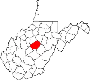
| Towns | Map of West Virginia Strange Creek, West Virginiahighlighting Braxton County | |
| Unincorporated communities |
| |
| Ghost towns | ||
| Footnotes | ‡This populated place also has portions in an adjacent county or counties | |
| ||