National Register of Historic Places listings in Hampshire County, West Virginia
This is a list of the National Register of Historic Places listings in Hampshire County, West Virginia.
This is intended to be a complete list of the properties and districts on the National Register of Historic Places in Hampshire County, West Virginia, United States. The locations of National Register properties and districts for which the latitude and longitude coordinates are included below, may be seen in an online map.[1]
There are 27 properties and districts listed on the National Register in the county.
- This National Park Service list is complete through NPS recent listings posted January 29, 2021.[2]
Barbour - Berkeley - Boone - Braxton - Brooke - Cabell - Calhoun - Clay - Doddridge - Fayette - Gilmer - Grant - Greenbrier - Hampshire - Hancock - Hardy - Harrison - Jackson - Jefferson - Kanawha - Lewis - Lincoln - Logan - Marion - Marshall - Mason - McDowell - Mercer - Mineral - Mingo - Monongalia - Monroe - Morgan - Nicholas - Ohio - Pendleton - Pleasants - Pocahontas - Preston - Putnam - Raleigh - Randolph - Ritchie - Roane - Summers - Taylor - Tucker - Tyler - Upshur - Wayne - Webster - Wetzel - Wirt - Wood - Wyoming |
Current listings
| [3] | Name on the Register[4] | Image | Date listed[5] | Location | City or town | Description |
|---|---|---|---|---|---|---|
| 1 | The Brill Octagon House |  The Brill Octagon House |
May 31, 2016 (#16000313) |
Capon Springs and McIlwee Rds. 39°08′16″N 78°29′27″W |
Capon Springs | |
| 2 | Capon Chapel | 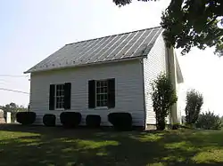 Capon Chapel |
December 12, 2012 (#12001048) |
Christian Church Rd. 39°16′12″N 78°26′39″W |
Capon Bridge | |
| 3 | Capon Springs | 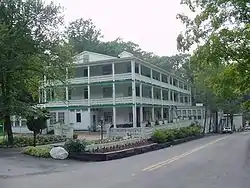 Capon Springs |
November 12, 1993 (#93001228) |
Capon Springs Rd. (County Route 16)[6][7] 39°07′56″N 78°28′46″W |
Capon Springs | |
| 4 | Fort Mill Ridge Civil War Trenches |  Fort Mill Ridge Civil War Trenches |
January 22, 2014 (#13001121) |
Fort Mill Ridge Rd. 39°19′28″N 78°47′37″W |
Romney | |
| 5 | Fort Van Meter | 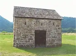 Fort Van Meter |
December 30, 2009 (#09001191) |
River Road 39°14′10″N 78°50′30″W |
Romney | |
| 6 | French's Mill | 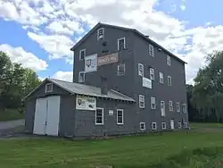 French's Mill |
December 16, 2014 (#14001056) |
Augusta-Ford Hill Rd. 39°17′38″N 78°38′12″W |
Augusta | |
| 7 | Hampshire County Courthouse | 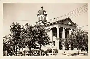 Hampshire County Courthouse |
September 7, 2005 (#05001006) |
66 N. High St. 39°20′32″N 78°45′22″W |
Romney | |
| 8 | Hebron Church |  Hebron Church |
December 16, 2014 (#14001057) |
10851 Carper's Pike 39°09′03″N 78°32′32″W |
Yellow Spring | |
| 9 | Hickory Grove | 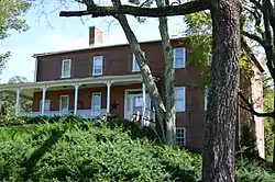 Hickory Grove |
August 18, 2011 (#11000556) |
County Route 8, 1 mile (1.6 km) south of U.S. Route 50 39°19′31″N 78°46′51″W |
Romney | |
| 10 | Hook's Tavern | 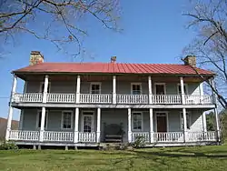 Hook's Tavern |
April 29, 2011 (#11000260) |
Junction of U.S. Route 50 and Smokey Hollow Rd. 39°18′03″N 78°24′51″W |
Capon Bridge | |
| 11 | Kuykendall Polygonal Barn | 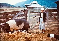 Kuykendall Polygonal Barn |
July 9, 1985 (#85001549) |
River Road 39°14′07″N 78°50′36″W |
Romney | |
| 12 | Nathaniel and Isaac Kuykendall House | 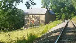 Nathaniel and Isaac Kuykendall House |
December 16, 2014 (#14001058) |
Address Restricted |
Romney | |
| 13 | Literary Hall |  Literary Hall |
May 29, 1979 (#79002577) |
Main and High Sts. 39°20′32″N 78°45′24″W |
Romney | |
| 14 | North River Mills Historic District | 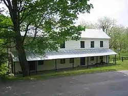 North River Mills Historic District |
May 4, 2011 (#11000261) |
Junction of County Roads 45/20 and 4/2 39°20′11″N 78°30′12″W |
North River Mills | |
| 15 | Old District Parsonage | 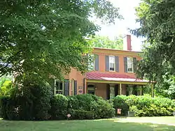 Old District Parsonage |
May 5, 2005 (#05000398) |
351 N. High St. 39°20′43″N 78°45′19″W |
Romney | |
| 16 | Old Pine Church | 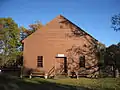 Old Pine Church |
December 12, 2012 (#12001049) |
Old Pine Church Rd. 39°12′55″N 78°55′33″W |
Purgitsville | |
| 17 | Pin Oak Fountain | 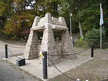 Pin Oak Fountain |
May 31, 2016 (#16000314) |
WV 29 and Falconwood Rd. 39°26′20″N 78°27′07″W |
Pin Oak | |
| 18 | Capt. David Pugh House | August 25, 2004 (#04000913) |
County Route 14 at County Route 23/4 39°14′39″N 78°27′47″W |
Hooks Mills | ||
| 19 | Scanlon Farm | 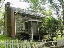 Scanlon Farm |
February 3, 1988 (#87002521) |
Three Churches Run Rd. 39°23′56″N 78°38′46″W |
Three Churches | |
| 20 | Sloan-Parker House | 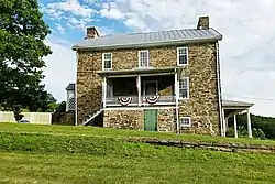 Sloan-Parker House |
June 5, 1975 (#75001892) |
East of Junction on U.S. Route 50 39°18′48″N 78°50′56″W |
Junction | |
| 21 | Capon Lake Whipple Truss Bridge |  Capon Lake Whipple Truss Bridge |
December 15, 2011 (#11000929) |
WV 259 north of its junction with County Route 16 39°09′28″N 78°32′13″W |
Capon Lake | |
| 22 | Springfield Brick House | January 2, 2013 (#12001141) |
12 Market St. 39°27′04″N 78°41′42″W |
Springfield | ||
| 23 | Sycamore Dale | 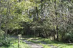 Sycamore Dale |
December 2, 1980 (#80004021) |
West of Romney off County Route 8 39°20′15″N 78°46′24″W |
Romney | |
| 24 | Valley View | 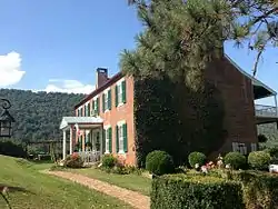 Valley View |
December 12, 2012 (#12001050) |
Depot Valley Rd. 39°21′21″N 78°45′36″W |
Romney | |
| 25 | Washington Bottom Farm |  Washington Bottom Farm |
November 29, 2001 (#01001328) |
WV 28 39°24′49″N 78°44′19″W |
Springfield | |
| 26 | Wilson-Wodrow-Mytinger House | 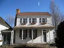 Wilson-Wodrow-Mytinger House |
August 22, 1977 (#77001375) |
51 W. Gravel Ln. 39°20′29″N 78°45′27″W |
Romney | |
| 27 | Yellow Spring Mill | 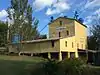 Yellow Spring Mill |
December 16, 2014 (#14001059) |
Junction of WV 259 and Cacapon River Rd. 39°10′57″N 78°30′36″W |
Yellow Spring |
See also
| Wikimedia Commons has media related to National Register of Historic Places in Hampshire County, West Virginia. |
References
- The latitude and longitude information provided in this table was derived originally from the National Register Information System, which has been found to be fairly accurate for about 99% of listings. Some locations in this table may have been corrected to current GPS standards.
- "National Register of Historic Places: Weekly List Actions". National Park Service, United States Department of the Interior. Retrieved on January 29, 2021.
- Numbers represent an alphabetical ordering by significant words. Various colorings, defined here, differentiate National Historic Landmarks and historic districts from other NRHP buildings, structures, sites or objects.
- "National Register Information System". National Register of Historic Places. National Park Service. April 24, 2008.
- The eight-digit number below each date is the number assigned to each location in the National Register Information System database, which can be viewed by clicking the number.
- The NRIS lists Capon Springs as "Address Restricted"; this location is derived from "Driving Directions". Capon Springs & Farms. Archived from the original on 2009-01-18. Retrieved 2009-01-18.
- General Highway Map: Hampshire County, West Virginia (Map). West Virginia Department of Transportation. 2008.
| Topics | ||
|---|---|---|
| Lists by county |
| |
| Other lists | ||
| ||
Municipalities and communities of Hampshire County, West Virginia, United States | ||
|---|---|---|
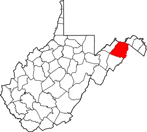
| City | Map of West Virginia highlighting Hampshire County | |
| Town | ||
| CDPs | ||
| Unincorporated communities |
| |
| ||