National Register of Historic Places listings in Marshall County, West Virginia
This is a list of the National Register of Historic Places listings in Marshall County, West Virginia.
This is intended to be a complete list of the properties and districts on the National Register of Historic Places in Marshall County, West Virginia, United States. The locations of National Register properties and districts for which the latitude and longitude coordinates are included below, may be seen in an online map.[1]
There are 12 properties and districts listed on the National Register in the county.
- This National Park Service list is complete through NPS recent listings posted January 29, 2021.[2]
Barbour - Berkeley - Boone - Braxton - Brooke - Cabell - Calhoun - Clay - Doddridge - Fayette - Gilmer - Grant - Greenbrier - Hampshire - Hancock - Hardy - Harrison - Jackson - Jefferson - Kanawha - Lewis - Lincoln - Logan - Marion - Marshall - Mason - McDowell - Mercer - Mineral - Mingo - Monongalia - Monroe - Morgan - Nicholas - Ohio - Pendleton - Pleasants - Pocahontas - Preston - Putnam - Raleigh - Randolph - Ritchie - Roane - Summers - Taylor - Tucker - Tyler - Upshur - Wayne - Webster - Wetzel - Wirt - Wood - Wyoming |
Current listings
| [3] | Name on the Register | Image | Date listed[4] | Location | City or town | Description |
|---|---|---|---|---|---|---|
| 1 | B & O Railroad Viaduct | 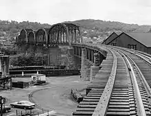 B & O Railroad Viaduct |
June 22, 1976 (#76001370) |
Spans the Ohio River at the southern end of Benwood 40°00′40″N 80°44′13″W |
Benwood | Extends into Belmont County, Ohio |
| 2 | Cameron City Pool-PWA Project 1196 |  Cameron City Pool-PWA Project 1196 |
July 14, 1993 (#93000612) |
Park St. 39°49′46″N 80°34′01″W |
Cameron | |
| 3 | Cameron Downtown |  Cameron Downtown |
December 4, 1998 (#98001473) |
Roughly bounded by Church St., Waynesburg Ave., Main St., and Park St. 39°49′35″N 80°33′57″W |
Cameron | |
| 4 | Bennett Cockayne House |  Bennett Cockayne House |
December 12, 2002 (#02001521) |
1111 Wheeling Ave. 39°56′33″N 80°45′17″W |
Glen Dale | |
| 5 | Ferrell-Holt House | 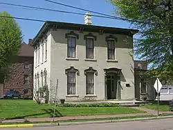 Ferrell-Holt House |
February 3, 1987 (#86003678) |
609 Jefferson Ave. 39°55′08″N 80°44′52″W |
Moundsville | |
| 6 | Grave Creek Mound | 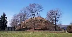 Grave Creek Mound |
October 15, 1966 (#66000751) |
Off WV 2 39°55′01″N 80°44′42″W |
Moundsville | |
| 7 | McMechen Lockmaster Houses on the Ohio River | 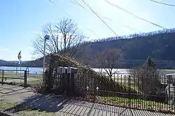 McMechen Lockmaster Houses on the Ohio River |
November 12, 1992 (#92001485) |
623-625 Grant St. 39°59′22″N 80°44′03″W |
McMechen | |
| 8 | Moundsville Commercial Historic District | 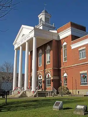 Moundsville Commercial Historic District |
March 17, 1995 (#95000252) |
Roughly Jefferson Ave. from 2nd to 7th Sts., 7th from Jefferson to Lafayette Ave., and Lafayette south of 7th 39°55′15″N 80°44′49″W |
Moundsville | |
| 9 | Prabhupada's Palace of Gold | 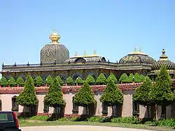 Prabhupada's Palace of Gold |
August 28, 2019 (#100002852) |
3759 McCreary’s Ridge Rd. 39°57′43″N 80°36′14″W |
Moundsville vicinity | |
| 10 | Bushrod Washington Price House | 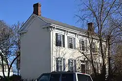 Bushrod Washington Price House |
November 22, 1995 (#95001326) |
1803 Virginia St. 39°55′22″N 80°43′57″W |
Moundsville | |
| 11 | Spencer Cemetery | 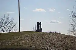 Spencer Cemetery |
December 12, 2012 (#12001051) |
668 Burley Hill Rd. 39°52′01″N 80°32′15″W |
Cameron | |
| 12 | West Virginia State Penitentiary | 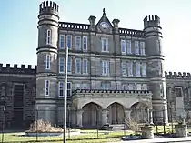 West Virginia State Penitentiary |
September 19, 1996 (#96000987) |
818 Jefferson Ave. 39°54′55″N 80°44′34″W |
Moundsville |
See also
| Wikimedia Commons has media related to National Register of Historic Places in Marshall County, West Virginia. |
References
- The latitude and longitude information provided in this table was derived originally from the National Register Information System, which has been found to be fairly accurate for about 99% of listings. Some locations in this table may have been corrected to current GPS standards.
- "National Register of Historic Places: Weekly List Actions". National Park Service, United States Department of the Interior. Retrieved on January 29, 2021.
- Numbers represent an alphabetical ordering by significant words. Various colorings, defined here, differentiate National Historic Landmarks and historic districts from other NRHP buildings, structures, sites or objects.
- The eight-digit number below each date is the number assigned to each location in the National Register Information System database, which can be viewed by clicking the number.
| Topics | ||
|---|---|---|
| Lists by county |
| |
| Other lists | ||
| ||
Municipalities and communities of Marshall County, West Virginia, United States | ||
|---|---|---|
| Cities | Map of West Virginia highlighting Marshall County | |
| Unincorporated communities |
| |
| Ghost towns | ||
| Footnotes | ‡This populated place also has portions in an adjacent county or counties | |
| ||