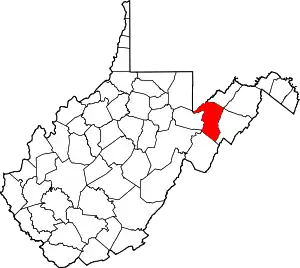
National Register of Historic Places listings in Grant County, West Virginia
This is a list of the National Register of Historic Places listings in Grant County, West Virginia.
This is intended to be a complete list of the properties and districts on the National Register of Historic Places in Grant County, West Virginia, United States. The locations of National Register properties and districts for which the latitude and longitude coordinates are included below, may be seen in a Google map.[1]
There are 7 properties listed on the National Register in the county.
- This National Park Service list is complete through NPS recent listings posted January 29, 2021.[2]
Barbour - Berkeley - Boone - Braxton - Brooke - Cabell - Calhoun - Clay - Doddridge - Fayette - Gilmer - Grant - Greenbrier - Hampshire - Hancock - Hardy - Harrison - Jackson - Jefferson - Kanawha - Lewis - Lincoln - Logan - Marion - Marshall - Mason - McDowell - Mercer - Mineral - Mingo - Monongalia - Monroe - Morgan - Nicholas - Ohio - Pendleton - Pleasants - Pocahontas - Preston - Putnam - Raleigh - Randolph - Ritchie - Roane - Summers - Taylor - Tucker - Tyler - Upshur - Wayne - Webster - Wetzel - Wirt - Wood - Wyoming |
Current listings
| [3] | Name on the Register | Image | Date listed[4] | Location | City or town | Description |
|---|---|---|---|---|---|---|
| 1 | Fairfax Stone Site | 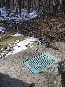 Fairfax Stone Site |
January 26, 1970 (#70000653) |
North of William at corner of Grant, Preston, and Tucker counties 39°11′42″N 79°29′16″W |
William | |
| 2 | Gormania Presbyterian Church | September 7, 2005 (#05001008) |
Mabis Ave., 0.1 miles south of U.S. Route 50 39°17′40″N 79°20′46″W |
Gormania | ||
| 3 | Grant County Courthouse |  Grant County Courthouse |
October 26, 1979 (#79003306) |
Virginia Ave. 38°59′35″N 79°07′15″W |
Petersburg | |
| 4 | Hermitage Motor Inn | 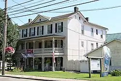 Hermitage Motor Inn |
January 14, 1986 (#86000776) |
Virginia Ave. 38°59′35″N 79°07′12″W |
Petersburg | |
| 5 | The Manor | 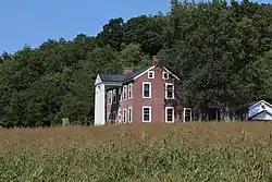 The Manor |
December 18, 1975 (#75001886) |
North of Petersburg off WV 42 39°00′36″N 79°07′40″W |
Petersburg | |
| 6 | Rohrbaugh Cabin | November 3, 1993 (#93000490) |
Smokehole Rd. (County Route 28/11), 3 miles south of junction with WV 28/WV 55, Monongahela National Forest 38°57′20″N 79°14′31″W |
Petersburg | ||
| 7 | Noah Snyder Farm | June 10, 1975 (#75001885) |
1.5 miles south of Lahmansville on County Route 5 39°06′35″N 79°05′56″W |
Lahmansville |
See also
| Wikimedia Commons has media related to National Register of Historic Places in Grant County, West Virginia. |
References
- The latitude and longitude information provided in this table was derived originally from the National Register Information System, which has been found to be fairly accurate for about 99% of listings. Some locations in this table may have been corrected to current GPS standards.
- "National Register of Historic Places: Weekly List Actions". National Park Service, United States Department of the Interior. Retrieved on January 29, 2021.
- Numbers represent an alphabetical ordering by significant words. Various colorings, defined here, differentiate National Historic Landmarks and historic districts from other NRHP buildings, structures, sites or objects.
- The eight-digit number below each date is the number assigned to each location in the National Register Information System database, which can be viewed by clicking the number.
| Topics | ||
|---|---|---|
| Lists by county |
| |
| Other lists | ||
| ||
Municipalities and communities of Grant County, West Virginia, United States | ||
|---|---|---|
| City | Map of West Virginia highlighting Grant County | |
| Town | ||
| Unincorporated communities | ||
| Footnotes | ‡This populated place also has portions in an adjacent county or counties | |
| ||