National Register of Historic Places listings in Doddridge County, West Virginia
This is a list of the National Register of Historic Places listings in Doddridge County, West Virginia.
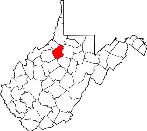
This is intended to be a complete list of the properties and districts on the National Register of Historic Places in Doddridge County, West Virginia, United States. The locations of National Register properties and districts for which the latitude and longitude coordinates are included below, may be seen in a Google map.[1]
There are 9 properties and districts listed on the National Register in the county.
- This National Park Service list is complete through NPS recent listings posted January 29, 2021.[2]
Barbour - Berkeley - Boone - Braxton - Brooke - Cabell - Calhoun - Clay - Doddridge - Fayette - Gilmer - Grant - Greenbrier - Hampshire - Hancock - Hardy - Harrison - Jackson - Jefferson - Kanawha - Lewis - Lincoln - Logan - Marion - Marshall - Mason - McDowell - Mercer - Mineral - Mingo - Monongalia - Monroe - Morgan - Nicholas - Ohio - Pendleton - Pleasants - Pocahontas - Preston - Putnam - Raleigh - Randolph - Ritchie - Roane - Summers - Taylor - Tucker - Tyler - Upshur - Wayne - Webster - Wetzel - Wirt - Wood - Wyoming |
Current listings
| [3] | Name on the Register | Image | Date listed[4] | Location | City or town | Description |
|---|---|---|---|---|---|---|
| 1 | Center Point Covered Bridge | 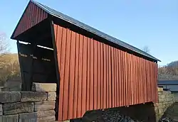 Center Point Covered Bridge |
August 29, 1983 (#83003235) |
County Route 10 just north of WV 23 39°23′22″N 80°38′04″W |
Center Point | |
| 2 | Lathrop Russell Charter House | 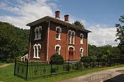 Lathrop Russell Charter House |
March 25, 1993 (#93000219) |
109 High St. 39°17′39″N 80°46′23″W |
West Union | |
| 3 | Doddridge County Courthouse | 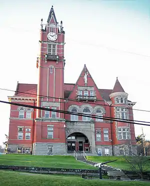 Doddridge County Courthouse |
March 18, 1982 (#82004316) |
Court Sq. 39°17′39″N 80°46′28″W |
West Union | |
| 4 | Gamsjager-Wysong Farm | September 4, 1986 (#86002181) |
County Route 66 39°07′28″N 80°41′33″W |
St. Clara | ||
| 5 | Krenn School | 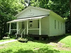 Krenn School |
March 29, 1989 (#89000181) |
County Route 66/Little Buck Run Rd. 39°07′25″N 80°41′26″W |
New Milton | |
| 6 | Silas P. Smith Opera House | 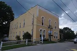 Silas P. Smith Opera House |
July 25, 2001 (#01000788) |
117 Court St. 39°17′38″N 80°46′30″W |
West Union | |
| 7 | W. Scott Stuart House | 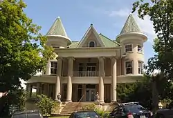 W. Scott Stuart House |
March 25, 1993 (#93000220) |
104 Chancery St. 39°17′38″N 80°46′28″W |
West Union | |
| 8 | West Union Downtown Historic District | 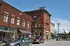 West Union Downtown Historic District |
May 22, 2003 (#03000458) |
Roughly bounded by the Baltimore & Ohio railroad line, Court St, and Cottage St. 39°17′41″N 80°46′31″W |
West Union | |
| 9 | West Union Residential Historic District | 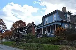 West Union Residential Historic District |
December 14, 2010 (#10001029) |
Roughly bounded by Court St., Stuart St., Wood St., and Garrison Ave. 39°17′35″N 80°46′33″W |
West Union |
See also
| Wikimedia Commons has media related to National Register of Historic Places in Doddridge County, West Virginia. |
References
- The latitude and longitude information provided in this table was derived originally from the National Register Information System, which has been found to be fairly accurate for about 99% of listings. Some locations in this table may have been corrected to current GPS standards.
- "National Register of Historic Places: Weekly List Actions". National Park Service, United States Department of the Interior. Retrieved on January 29, 2021.
- Numbers represent an alphabetical ordering by significant words. Various colorings, defined here, differentiate National Historic Landmarks and historic districts from other NRHP buildings, structures, sites or objects.
- The eight-digit number below each date is the number assigned to each location in the National Register Information System database, which can be viewed by clicking the number.
| Topics | ||
|---|---|---|
| Lists by county |
| |
| Other lists | ||
| ||
Municipalities and communities of Doddridge County, West Virginia, United States | ||
|---|---|---|
| Town | Doddridge County map | |
| Unincorporated communities | ||
| ||