National Register of Historic Places listings in Greenbrier County, West Virginia
This is a list of the National Register of Historic Places listings in Greenbrier County, West Virginia.
This is intended to be a complete list of the properties and districts on the National Register of Historic Places in Greenbrier County, West Virginia, United States. The locations of National Register properties and districts for which the latitude and longitude coordinates are included below, may be seen in an online map.[1]
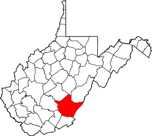
There are 44 properties and districts listed on the National Register in the county, 1 of which is a National Historic Landmark.
- This National Park Service list is complete through NPS recent listings posted January 29, 2021.[2]
Barbour - Berkeley - Boone - Braxton - Brooke - Cabell - Calhoun - Clay - Doddridge - Fayette - Gilmer - Grant - Greenbrier - Hampshire - Hancock - Hardy - Harrison - Jackson - Jefferson - Kanawha - Lewis - Lincoln - Logan - Marion - Marshall - Mason - McDowell - Mercer - Mineral - Mingo - Monongalia - Monroe - Morgan - Nicholas - Ohio - Pendleton - Pleasants - Pocahontas - Preston - Putnam - Raleigh - Randolph - Ritchie - Roane - Summers - Taylor - Tucker - Tyler - Upshur - Wayne - Webster - Wetzel - Wirt - Wood - Wyoming |
Current listings
| [3] | Name on the Register | Image | Date listed[4] | Location | City or town | Description |
|---|---|---|---|---|---|---|
| 1 | Alderson Bridge |  Alderson Bridge |
December 4, 1991 (#91001730) |
Monroe St. across the Greenbrier River 37°43′29″N 80°38′36″W |
Alderson | |
| 2 | Alderson Historic District | 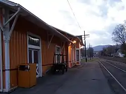 Alderson Historic District |
November 12, 1993 (#93001231) |
Roughly along Monroe St., Riverview Dr., Railroad Ave., and adjacent streets 37°43′29″N 80°38′32″W |
Alderson | |
| 3 | Alexander W. Arbuckle I House | May 3, 1976 (#76001933) |
2 miles north of Lewisburg on Arbuckle Lane 37°51′41″N 80°25′24″W |
Lewisburg | ||
| 4 | Argabrite House | 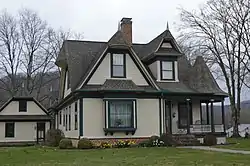 Argabrite House |
April 16, 2009 (#08001236) |
504 Virginia St. 37°43′48″N 80°38′10″W |
Alderson | |
| 5 | Sam Black Church | 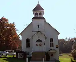 Sam Black Church |
March 5, 1999 (#99000288) |
U.S. Route 60 at its junction with County Route 60/5 37°53′55″N 80°37′50″W |
Smoot | |
| 6 | Blue Bend Forest Camp | April 20, 1994 (#94000352) |
4 miles west of WV 92 on Alvon-Blue Bend-Anthony Rd., County Route 16/2 37°55′14″N 80°16′06″W |
Alvon | ||
| 7 | Blue Sulphur Springs Pavilion | 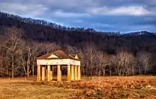 Blue Sulphur Springs Pavilion |
October 29, 1992 (#92001481) |
County Route 25, 9 miles north of Alderson 37°49′42″N 80°38′30″W |
Blue Sulphur Springs | |
| 8 | Confederate Cemetery at Lewisburg | 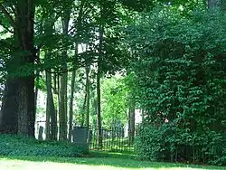 Confederate Cemetery at Lewisburg |
February 2, 1988 (#87002535) |
Maple St. and U.S. Route 60, Library Park 37°48′07″N 80°27′06″W |
Lewisburg | |
| 9 | David S. Creigh House | November 12, 1975 (#75001888) |
Southwest of Lewisburg off the Davis-Stuart Rd. 37°46′14″N 80°28′33″W |
Lewisburg | ||
| 10 | Deitz Farm | 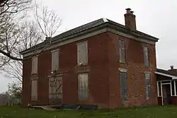 Deitz Farm |
April 17, 1992 (#92000304) |
Junction of County Routes 28 and 60/32 37°54′34″N 80°40′10″W |
Meadow Bluff | |
| 11 | Edgefield | 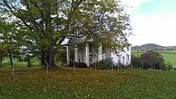 Edgefield |
December 12, 2012 (#12001047) |
461 Brownstown Rd. 37°59′47″N 80°21′21″W |
Renick | |
| 12 | Elmhurst | June 5, 1975 (#75001887) |
U.S. Route 60 at the Greenbrier River 37°46′50″N 80°23′47″W |
Caldwell | ||
| 13 | Greenbrier County Courthouse and Lewis Spring | 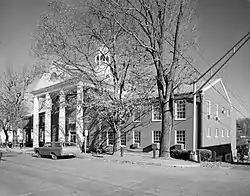 Greenbrier County Courthouse and Lewis Spring |
August 17, 1973 (#73001900) |
Corner of Court and Randolph Sts. 37°48′11″N 80°26′46″W |
Lewisburg | |
| 14 | The Greenbrier | 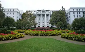 The Greenbrier |
October 9, 1974 (#74002000) |
Off U.S. Route 60 37°47′41″N 80°20′09″W |
White Sulphur Springs | |
| 15 | Hartland | June 10, 1975 (#75001889) |
2 miles west of Lewisburg on Houfnaggle Rd. 37°48′06″N 80°28′29″W |
Lewisburg | ||
| 16 | Herns Mill Covered Bridge | 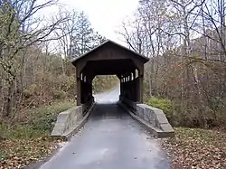 Herns Mill Covered Bridge |
June 4, 1981 (#81000598) |
County Route 40 near its junction with County Route 60/11 37°49′57″N 80°30′18″W |
Lewisburg | |
| 17 | Hokes Mill Covered Bridge | 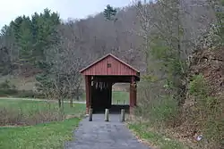 Hokes Mill Covered Bridge |
June 4, 1981 (#81000599) |
County Route 62 at Hokes Mill crossing of Second Creek 37°41′50″N 80°31′30″W |
Ronceverte | |
| 18 | Homeplace | January 17, 2008 (#07001415) |
U.S. Route 219 North 37°54′43″N 80°22′55″W |
Frankford | ||
| 19 | Hopkins Mountain Historic District | April 14, 1994 (#94000353) |
Along Forest Road 139 (Hopkins Mountain Rd), north of County Road 16/2 (Alvon-Blue Bend-Anthony Road), approximately 4 miles west of WV 92 37°57′08″N 80°15′52″W |
Alvon | ||
| 20 | Lewisburg Historic District |  Lewisburg Historic District |
July 7, 1978 (#78002795) |
Irregular pattern along U.S. Routes 60 and 219 37°48′06″N 80°26′44″W |
Lewisburg | |
| 21 | Maple Street Historic District | 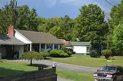 Maple Street Historic District |
April 6, 1988 (#87002529) |
107-121 Maple St. 37°48′18″N 80°26′58″W |
Lewisburg | |
| 22 | McClung's Price Place | 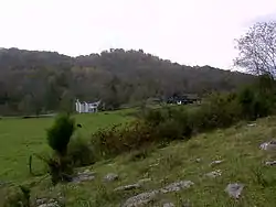 McClung's Price Place |
August 3, 2007 (#07000782) |
699 Savannah Ln. 37°53′39″N 80°24′59″W |
Lewisburg | |
| 23 | Meadow River Lumber Building | November 13, 1997 (#97001411) |
U.S. Route 219 South at State Fair of West Virginia 37°46′39″N 80°27′45″W |
Fairlea | ||
| 24 | Alexander McVeigh Miller House | 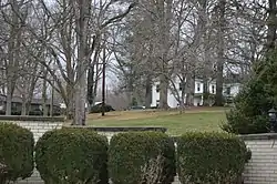 Alexander McVeigh Miller House |
December 15, 1978 (#78002794) |
Hemlock Ave. 37°43′53″N 80°38′05″W |
Alderson | |
| 25 | Morlunda | March 25, 1977 (#77001374) |
Northwest of Lewisburg on County Route 40 37°49′54″N 80°29′28″W |
Lewisburg | ||
| 26 | Mountain Home | November 28, 1980 (#80004020) |
Southwest of White Sulphur Springs on U.S. Route 60 37°46′24″N 80°21′10″W |
White Sulphur Springs | Boundary increase approved December 23, 2020 | |
| 27 | Mt. Tabor Baptist Church | 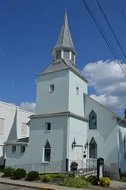 Mt. Tabor Baptist Church |
December 12, 1976 (#76001934) |
Court and Foster Sts. 37°48′07″N 80°26′50″W |
Lewisburg | |
| 28 | New Deal Resources in Greenbrier State Forest Historic District | August 7, 2019 (#100002851) |
1541 County Road 6/2 (Harts Run Rd.) 37°41′07″N 80°21′50″W |
Caldwell | ||
| 29 | John A. North House |  John A. North House |
October 9, 1974 (#74001998) |
100 Church St. 37°48′11″N 80°26′54″W |
Lewisburg | |
| 30 | Oakhurst Links | December 4, 2001 (#01001327) |
1 Montague Dr. 37°49′41″N 80°16′47″W |
White Sulphur Springs | ||
| 31 | Old Stone Church | 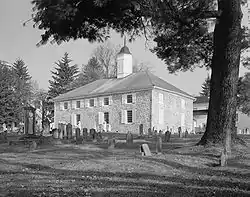 Old Stone Church |
February 23, 1972 (#72001286) |
Church and Foster Sts. 37°48′04″N 80°26′55″W |
Lewisburg | |
| 32 | Organ Cave | 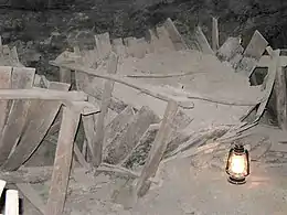 Organ Cave |
May 5, 2005 (#05000397) |
WV 63, 0.5 miles east of its junction with U.S. Route 219 37°43′12″N 80°26′09″W |
Ronceverte | |
| 33 | Gov. Samuel Price House | 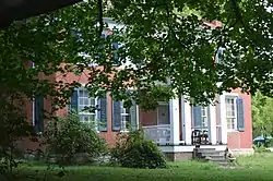 Gov. Samuel Price House |
June 20, 1975 (#75001890) |
224 N. Court St. 37°48′15″N 80°26′39″W |
Lewisburg | |
| 34 | Renick Farm | 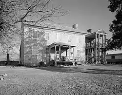 Renick Farm |
April 4, 1997 (#96000525) |
U.S. Route 219 near its junction with County Route 9 37°59′00″N 80°21′04″W |
Renick | |
| 35 | Ronceverte Historic District | 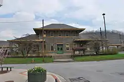 Ronceverte Historic District |
May 6, 2005 (#05000396) |
Roughly along Main St., Pocahontas, Monroe, and Greenbrier Avenues 37°45′00″N 80°28′03″W |
Ronceverte | |
| 36 | South Church Street Historic District | 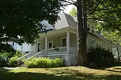 South Church Street Historic District |
February 2, 1988 (#87002528) |
S. Church St. 37°48′02″N 80°27′00″W |
Lewisburg | |
| 37 | Stone Manse | April 15, 2004 (#04000307) |
County Route 38 (Stonehouse Rd.) 37°47′52″N 80°22′45″W |
Caldwell | ||
| 38 | Stuart Manor | July 27, 1973 (#73001901) |
Southwest of Lewisburg off U.S. Route 219 37°45′58″N 80°29′59″W |
Lewisburg | ||
| 39 | Supreme Court Library Building | 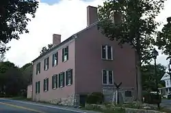 Supreme Court Library Building |
February 23, 1972 (#72001287) |
U.S. Route 60 West and Courtney Dr. 37°48′12″N 80°26′53″W |
Lewisburg | |
| 40 | Tuckwiller Tavern | March 4, 1975 (#75001891) |
2 miles northwest of Lewisburg on U.S. Route 60 37°49′21″N 80°28′45″W |
Lewisburg | ||
| 41 | Tuscawilla | December 19, 1979 (#79002576) |
South of Lewisburg off U.S. Route 219 37°47′00″N 80°27′00″W |
Lewisburg | ||
| 42 | John Wesley Methodist Church | 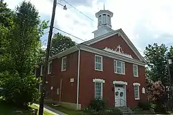 John Wesley Methodist Church |
June 5, 1974 (#74001997) |
E. Foster St. 37°47′59″N 80°26′40″W |
Lewisburg | |
| 43 | James Withrow House | 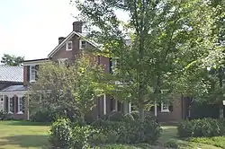 James Withrow House |
December 31, 1974 (#74001999) |
200 N. Jefferson St. 37°48′14″N 80°26′35″W |
Lewisburg | |
| 44 | James Wylie House | February 5, 1990 (#89002318) |
208 E. Main St. 37°47′48″N 80°17′52″W |
White Sulphur Springs |
See also
| Wikimedia Commons has media related to National Register of Historic Places in Greenbrier County, West Virginia. |
References
- The latitude and longitude information provided in this table was derived originally from the National Register Information System, which has been found to be fairly accurate for about 99% of listings. Some locations in this table may have been corrected to current GPS standards.
- "National Register of Historic Places: Weekly List Actions". National Park Service, United States Department of the Interior. Retrieved on January 29, 2021.
- Numbers represent an alphabetical ordering by significant words. Various colorings, defined here, differentiate National Historic Landmarks and historic districts from other NRHP buildings, structures, sites or objects.
- The eight-digit number below each date is the number assigned to each location in the National Register Information System database, which can be viewed by clicking the number.
| Topics | ||
|---|---|---|
| Lists by county |
| |
| Other lists | ||
| ||