National Register of Historic Places listings in Wood County, West Virginia
This is a list of the National Register of Historic Places listings in Wood County, West Virginia.
This is intended to be a complete list of the properties and districts on the National Register of Historic Places in Wood County, West Virginia, United States. The locations of National Register properties and districts for which the latitude and longitude coordinates are included below, may be seen in a Google map.[1]
There are 47 properties and districts listed on the National Register in the county. Another 4 properties were once listed but have been removed.
- This National Park Service list is complete through NPS recent listings posted February 5, 2021.[2]
Barbour - Berkeley - Boone - Braxton - Brooke - Cabell - Calhoun - Clay - Doddridge - Fayette - Gilmer - Grant - Greenbrier - Hampshire - Hancock - Hardy - Harrison - Jackson - Jefferson - Kanawha - Lewis - Lincoln - Logan - Marion - Marshall - Mason - McDowell - Mercer - Mineral - Mingo - Monongalia - Monroe - Morgan - Nicholas - Ohio - Pendleton - Pleasants - Pocahontas - Preston - Putnam - Raleigh - Randolph - Ritchie - Roane - Summers - Taylor - Tucker - Tyler - Upshur - Wayne - Webster - Wetzel - Wirt - Wood - Wyoming |
Current listings
| [3] | Name on the Register | Image | Date listed[4] | Location | City or town | Description |
|---|---|---|---|---|---|---|
| 1 | Avery Street Historic District | 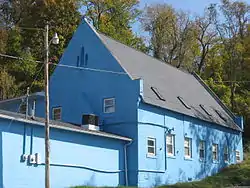 Avery Street Historic District |
April 15, 1986 (#86000849) |
Roughly bounded by Nineteenth, Spring and Quincy, Eighth, and Market Sts. 39°16′15″N 81°33′18″W |
Parkersburg | |
| 2 | Bethel AME Church | 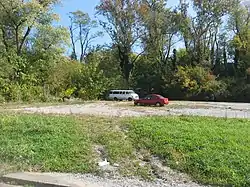 Bethel AME Church |
October 8, 1998 (#82001767) |
820 Clay St. 39°15′58″N 81°33′18″W |
Parkersburg | Demolished |
| 3 | Bethel Presbyterian Church |  Bethel Presbyterian Church |
March 31, 2014 (#14000107) |
7132 Old St. Marys Pike 39°19′57″N 81°25′18″W |
Waverly | |
| 4 | W. H. Bickel Estate |  W. H. Bickel Estate |
February 11, 2004 (#04000027) |
Number One Bickel Mansion Dr. 39°14′52″N 81°35′17″W |
Parkersburg | |
| 5 | Blennerhassett Hotel | 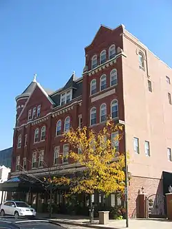 Blennerhassett Hotel |
December 10, 1982 (#82001768) |
316 Market St. 39°15′54″N 81°33′42″W |
Parkersburg | |
| 6 | Blennerhassett Island Historic District | 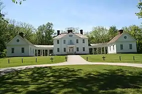 Blennerhassett Island Historic District |
September 7, 1972 (#72001294) |
On the Ohio River, 1.7 miles south of Parkersburg 39°16′19″N 81°37′12″W |
Parkersburg | |
| 7 | Carnegie Library | 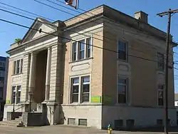 Carnegie Library |
October 8, 1982 (#82001769) |
725 Green St. 39°15′56″N 81°33′22″W |
Parkersburg | |
| 8 | Case House |  Case House |
October 8, 1982 (#82001770) |
710 Ann St. 39°16′09″N 81°33′33″W |
Parkersburg | Demolished |
| 9 | Citizens National Bank |  Citizens National Bank |
October 8, 1982 (#82001772) |
219 4th St. 39°15′56″N 81°33′42″W |
Parkersburg | Demolished in 2018[5] |
| 10 | Cook House | 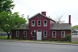 Cook House |
June 7, 1978 (#78002812) |
1301 Murdoch Ave. 39°16′29″N 81°33′20″W |
Parkersburg | |
| 11 | Henry Cooper House | 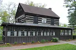 Henry Cooper House |
February 6, 1986 (#86000828) |
Park Ave. 39°16′18″N 81°31′48″W |
Parkersburg | |
| 12 | Elks Club | 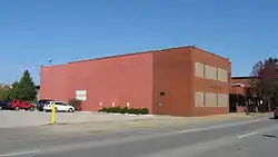 Elks Club |
October 8, 1982 (#82001773) |
515 Juliana St. 39°16′02″N 81°33′39″W |
Parkersburg | Demolished |
| 13 | First Baptist Church | 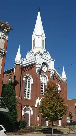 First Baptist Church |
December 10, 1982 (#82001774) |
813 Market St. 39°16′05″N 81°33′25″W |
Parkersburg | |
| 14 | First Presbyterian Church/Calvary Temple Evangelical Church | 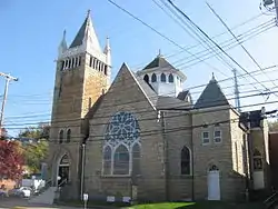 First Presbyterian Church/Calvary Temple Evangelical Church |
December 10, 1982 (#82001775) |
946 Market St. 39°16′06″N 81°33′18″W |
Parkersburg | |
| 15 | Fort Boreman | 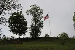 Fort Boreman |
April 17, 2003 (#02001690) |
Overlooking the confluence of the Little Kanawha and Ohio Rivers[6] 39°15′42″N 81°34′07″W |
Parkersburg | |
| 16 | Gould House/Greater Parkersburg Chamber of Commerce |  Gould House/Greater Parkersburg Chamber of Commerce |
October 8, 1982 (#82001776) |
720 Juliana St. 39°16′05″N 81°33′29″W |
Parkersburg | |
| 17 | Henderson Hall Historic District |  Henderson Hall Historic District |
April 17, 1986 (#86000811) |
CR 21/2 off WV 14 39°22′40″N 81°28′58″W |
Williamstown | |
| 18 | House at 10th and Avery Streets |  House at 10th and Avery Streets |
December 10, 1982 (#82001777) |
10th and Avery Sts. 39°16′10″N 81°33′12″W |
Parkersburg | |
| 19 | Jackson Memorial Fountain |  Jackson Memorial Fountain |
August 23, 1984 (#84003686) |
Park Ave. and 17th St. 39°16′11″N 81°31′55″W |
Parkersburg | |
| 20 | Julia-Ann Square Historic District |  Julia-Ann Square Historic District |
May 24, 1977 (#77001380) |
Both sides of Juliana and Ann Sts. from cemetery to 9th St. 39°16′16″N 81°33′21″W |
Parkersburg | |
| 21 | Isaac F. Lane House |  Isaac F. Lane House |
June 26, 2019 (#100003252) |
1399 Waverly Rd. 39°21′27″N 81°24′18″W |
Williamstown vicinity | |
| 22 | Henry Logan Memorial AME Church |  Henry Logan Memorial AME Church |
December 16, 1982 (#82001778) |
Ann and 6th Sts. 39°16′06″N 81°33′41″W |
Parkersburg | |
| 23 | Masonic Temple | 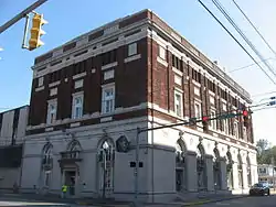 Masonic Temple |
October 8, 1982 (#82001779) |
900 Market St. 39°16′04″N 81°33′22″W |
Parkersburg | |
| 24 | Mather Building/Franklin & DeHaven Jewelers | 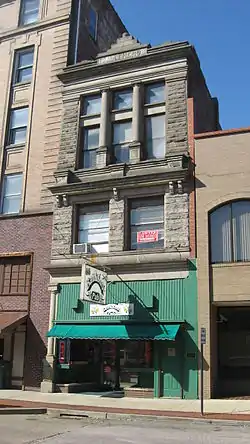 Mather Building/Franklin & DeHaven Jewelers |
October 8, 1982 (#82001780) |
405 Market St. 39°15′55″N 81°33′43″W |
Parkersburg | Demolished in 2018[5] |
| 25 | Meldahl House | May 17, 1991 (#91000550) |
Washington Bottom Rd. off WV 892 39°13′28″N 81°40′57″W |
Washington | ||
| 26 | Dr. W. W. Monroe House |  Dr. W. W. Monroe House |
August 1, 2012 (#12000469) |
1703 Park Avenue 39°16′10″N 81°31′58″W |
Parkersburg | |
| 27 | George Neale Jr. House |  George Neale Jr. House |
January 10, 1980 (#80004045) |
331 Juliana St. 39°15′58″N 81°33′46″W |
Parkersburg | |
| 28 | Oakland | 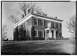 Oakland |
May 29, 1979 (#79002604) |
1131 7th St. 39°15′52″N 81°32′36″W |
Parkersburg | |
| 29 | Oeldorf Building/Wetherell's Jewelers |  Oeldorf Building/Wetherell's Jewelers |
December 10, 1982 (#82001781) |
809 Market St. 39°16′04″N 81°33′25″W |
Parkersburg | |
| 30 | Parkersburg High School-Washington Avenue Historic District |  Parkersburg High School-Washington Avenue Historic District |
July 16, 1992 (#92000895) |
Washington Ave. from Park Ave. to Dudley Ave., including 2101 Dudley 39°16′34″N 81°32′23″W |
Parkersburg | |
| 31 | Parkersburg Women's Club | 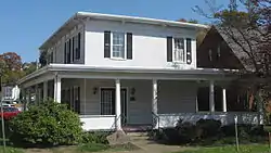 Parkersburg Women's Club |
October 8, 1982 (#82001782) |
323 9th St. 39°16′02″N 81°33′21″W |
Parkersburg | |
| 32 | St. Francis Xavier Church | 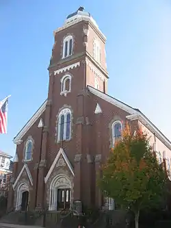 St. Francis Xavier Church |
December 22, 1978 (#78002813) |
532 Market St. 39°15′58″N 81°33′35″W |
Parkersburg | |
| 33 | Sharon Lodge No. 28 IOOF |  Sharon Lodge No. 28 IOOF |
October 8, 1982 (#82001784) |
316 5th St. 39°15′55″N 81°33′37″W |
Parkersburg | |
| 34 | Sixth Street Railroad Bridge | 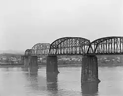 Sixth Street Railroad Bridge |
December 10, 1982 (#82001785) |
6th Street 39°16′15″N 81°33′54″W |
Parkersburg | Extends into Washington County, Ohio |
| 35 | Smith Building |  Smith Building |
December 10, 1982 (#82001786) |
310½ Market St. 39°15′53″N 81°33′44″W |
Parkersburg | Demolished |
| 36 | W.H. Smith Hardware Company Building | 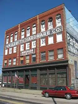 W.H. Smith Hardware Company Building |
May 2, 2003 (#03000349) |
119 3rd St. 39°15′58″N 81°33′49″W |
Parkersburg | |
| 37 | Smoot Theater |  Smoot Theater |
October 8, 1982 (#82001787) |
213 5th St. 39°15′59″N 81°33′39″W |
Parkersburg | |
| 38 | Tavenner House | 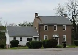 Tavenner House |
November 10, 1982 (#82001788) |
2401 Camden Ave. 39°15′19″N 81°33′04″W |
Parkersburg | |
| 39 | Tomlinson Mansion |  Tomlinson Mansion |
July 24, 1974 (#74002022) |
901 W. 3rd St. 39°24′02″N 81°27′49″W |
Williamstown | |
| 40 | Tracewell House | April 26, 1991 (#91000450) |
WV 95 west of Gihon Rd. 39°14′54″N 81°35′24″W |
Parkersburg | ||
| 41 | Trinity Episcopal Church Rectory |  Trinity Episcopal Church Rectory |
December 10, 1982 (#82001789) |
430 Juliana St. 39°15′59″N 81°33′41″W |
Parkersburg | |
| 42 | Trinity Protestant Episcopal Church |  Trinity Protestant Episcopal Church |
December 10, 1982 (#82001790) |
424 Juliana St. 39°15′59″N 81°33′41″W |
Parkersburg | |
| 43 | Union Trust & Deposit Co./Union Trust National Bank | 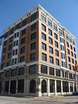 Union Trust & Deposit Co./Union Trust National Bank |
October 8, 1982 (#82001791) |
700 Market St. 39°16′01″N 81°33′29″W |
Parkersburg | |
| 44 | Peter G. Van Winkle House | 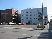 Peter G. Van Winkle House |
October 8, 1982 (#82001792) |
600 Juliana St. 39°16′02″N 81°33′35″W |
Parkersburg | Demolished |
| 45 | Walton Wait House |  Walton Wait House |
December 10, 1982 (#82001793) |
1232 Murdoch Ave. 39°16′27″N 81°33′19″W |
Parkersburg | Demolished |
| 46 | Windmill Quaker State |  Windmill Quaker State |
October 8, 1982 (#82001795) |
800 Murdoch Ave. 39°16′11″N 81°33′32″W |
Parkersburg | |
| 47 | Wood County Courthouse | 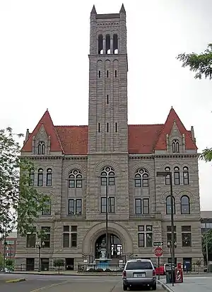 Wood County Courthouse |
August 29, 1979 (#79002606) |
Court Sq. at 3rd and Market St. 39°15′53″N 81°33′46″W |
Parkersburg |
Former listings
| [3] | Name on the Register | Image | Date listed | Date removed | Location | City or town | Summary |
|---|---|---|---|---|---|---|---|
| 1 | Chancellor Hardware | December 10, 1982 (#82001771) | September 21, 1992 | 114 3rd St. |
Parkersburg | Demolished | |
| 2 | Guaranty Building | October 8, 1982 (#82001891) | March 6, 1992 | 217 4th St. |
Parkersburg | Demolished January 29, 1992. | |
| 3 | Parkersburg City Hall | December 11, 1979 (#79002605) | April 2, 1981 | 5th and Market Sts. |
Parkersburg | Demolished 1980 | |
| 4 | Robb Apartments | October 8, 1982 (#82001783) | December 22, 1987 | 201 8th St. |
Parkersburg | Demolished September 28, 1987 | |
| 5 | West Central WV Community Action Assoc., Inc. | October 8, 1982 (#82001794) | January 5, 1988 | 804 Ann St. |
Parkersburg |
See also
| Wikimedia Commons has media related to National Register of Historic Places in Wood County, West Virginia. |
References
- The latitude and longitude information provided in this table was derived originally from the National Register Information System, which has been found to be fairly accurate for about 99% of listings. Some locations in this table may have been corrected to current GPS standards.
- "National Register of Historic Places: Weekly List Actions". National Park Service, United States Department of the Interior. Retrieved on February 5, 2021.
- Numbers represent an alphabetical ordering by significant words. Various colorings, defined here, differentiate National Historic Landmarks and historic districts from other NRHP buildings, structures, sites or objects.
- The eight-digit number below each date is the number assigned to each location in the National Register Information System database, which can be viewed by clicking the number.
- Morgan, Brittany. "The Citizens National Bank and the Mather Building Being Demolished". Retrieved 2018-07-01.
- Fort Boreman Park, Wood County Parks, 2010. Accessed 2013-05-07.
| Topics | ||
|---|---|---|
| Lists by county |
| |
| Other lists | ||
| ||