National Register of Historic Places listings in Wayne County, West Virginia
This is a list of the National Register of Historic Places listings in Wayne County, West Virginia.
This is intended to be a complete list of the properties and districts on the National Register of Historic Places in Wayne County, West Virginia, United States. The locations of National Register properties and districts for which the latitude and longitude coordinates are included below, may be seen in an online map.[1]
There are 5 properties listed on the National Register in the county.
- This National Park Service list is complete through NPS recent listings posted February 5, 2021.[2]
Barbour - Berkeley - Boone - Braxton - Brooke - Cabell - Calhoun - Clay - Doddridge - Fayette - Gilmer - Grant - Greenbrier - Hampshire - Hancock - Hardy - Harrison - Jackson - Jefferson - Kanawha - Lewis - Lincoln - Logan - Marion - Marshall - Mason - McDowell - Mercer - Mineral - Mingo - Monongalia - Monroe - Morgan - Nicholas - Ohio - Pendleton - Pleasants - Pocahontas - Preston - Putnam - Raleigh - Randolph - Ritchie - Roane - Summers - Taylor - Tucker - Tyler - Upshur - Wayne - Webster - Wetzel - Wirt - Wood - Wyoming |
Current listings
| [3] | Name on the Register | Image | Date listed[4] | Location | City or town | Description |
|---|---|---|---|---|---|---|
| 1 | Camp Mad Anthony Wayne | December 12, 2002 (#02001531) |
2125 Spring Valley Dr. 38°22′04″N 82°30′47″W |
Huntington | ||
| 2 | Fort Gay High School | December 18, 2017 (#100001903) |
675 Court St. 38°07′02″N 82°35′40″W |
Fort Gay | ||
| 3 | Joseph S. Miller House | 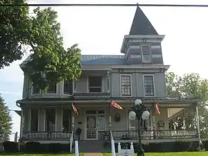 Joseph S. Miller House |
March 29, 1989 (#89000180) |
748 Beech St. 38°23′59″N 82°34′01″W |
Kenova | |
| 4 | Z. D. Ramsdell House |  Z. D. Ramsdell House |
August 18, 1983 (#83003254) |
1108 B St. 38°23′49″N 82°33′15″W |
Ceredo | |
| 5 | Wildcat Branch Petroglyphs | July 22, 1979 (#79002603) |
Address Restricted |
Fort Gay |
See also
| Wikimedia Commons has media related to National Register of Historic Places in Wayne County, West Virginia. |
References
- The latitude and longitude information provided in this table was derived originally from the National Register Information System, which has been found to be fairly accurate for about 99% of listings. Some locations in this table may have been corrected to current GPS standards.
- "National Register of Historic Places: Weekly List Actions". National Park Service, United States Department of the Interior. Retrieved on February 5, 2021.
- Numbers represent an alphabetical ordering by significant words. Various colorings, defined here, differentiate National Historic Landmarks and historic districts from other NRHP buildings, structures, sites or objects.
- The eight-digit number below each date is the number assigned to each location in the National Register Information System database, which can be viewed by clicking the number.
| Topics | ||
|---|---|---|
| Lists by county |
| |
| Other lists | ||
| ||
Municipalities and communities of Wayne County, West Virginia, United States | ||
|---|---|---|
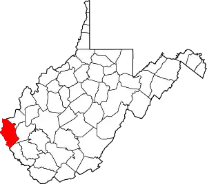
| Cities | Wayne County map | |
| Towns | ||
| CDPs | ||
| Unincorporated communities |
| |
| Footnotes | ‡This populated place also has portions in an adjacent county or counties | |
| ||