National Register of Historic Places listings in Monongalia County, West Virginia
This is a list of the National Register of Historic Places listings in Monongalia County, West Virginia.
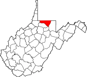
This is intended to be a complete list of the properties and districts on the National Register of Historic Places in Monongalia County, West Virginia, United States. The locations of National Register properties and districts for which the latitude and longitude coordinates are included below, may be seen in a Google map.[1]
There are 44 properties and districts listed on the National Register in the county, 1 of which is a National Historic Landmark.
- This National Park Service list is complete through NPS recent listings posted January 29, 2021.[2]
Barbour - Berkeley - Boone - Braxton - Brooke - Cabell - Calhoun - Clay - Doddridge - Fayette - Gilmer - Grant - Greenbrier - Hampshire - Hancock - Hardy - Harrison - Jackson - Jefferson - Kanawha - Lewis - Lincoln - Logan - Marion - Marshall - Mason - McDowell - Mercer - Mineral - Mingo - Monongalia - Monroe - Morgan - Nicholas - Ohio - Pendleton - Pleasants - Pocahontas - Preston - Putnam - Raleigh - Randolph - Ritchie - Roane - Summers - Taylor - Tucker - Tyler - Upshur - Wayne - Webster - Wetzel - Wirt - Wood - Wyoming |
Current listings
| [3] | Name on the Register[4] | Image | Date listed[5] | Location | City or town | Description |
|---|---|---|---|---|---|---|
| 1 | D.I.B. Anderson Farm | 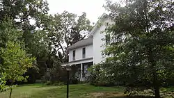 D.I.B. Anderson Farm |
March 25, 1994 (#94000213) |
3333 Collins Ferry Rd. 39°39′36″N 79°58′27″W |
Morgantown | |
| 2 | Brown Building | 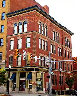 Brown Building |
July 8, 1985 (#85001514) |
295 High St. 39°37′47″N 79°57′22″W |
Morgantown | |
| 3 | Camp Rhododendron | 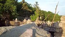 Camp Rhododendron |
May 15, 1991 (#91000545) |
Off Interstate 68 8 mi (13 km) east of Morgantown 39°38′18″N 79°48′56″W |
Morgantown | |
| 4 | Chancery Hill Historic District |  Chancery Hill Historic District |
December 3, 1999 (#99001401) |
Roughly bounded by S. High St., Oak Grove Cemetery, Waitman, Allison, and Simpson Sts. and 256 Prairie Ave. 39°37′20″N 79°57′43″W |
Morgantown | The 2001 boundary increase added the Alexander Wade House to the district. |
| 5 | Judge Frank Cox House | 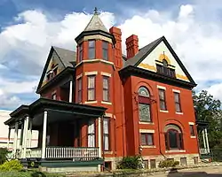 Judge Frank Cox House |
January 12, 1984 (#84003626) |
206 Spruce St. 39°37′42″N 79°57′20″W |
Morgantown | |
| 6 | Dents Run Covered Bridge | 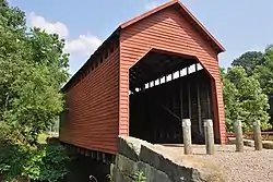 Dents Run Covered Bridge |
June 4, 1981 (#81000604) |
County Route 43/4 near junction of County Route 43 crossing Dents Run 39°37′26″N 80°02′24″W |
Laurel Point | |
| 7 | Dering Building | 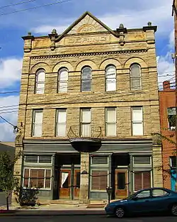 Dering Building |
November 4, 1994 (#94001288) |
175-177 Walnut St. 39°37′49″N 79°57′25″W |
Morgantown | |
| 8 | Downtown Morgantown Historic District | 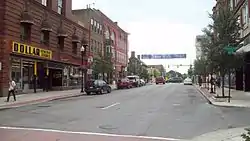 Downtown Morgantown Historic District |
May 2, 1996 (#96000441) |
Roughly bounded by Chestnut and Spruce Sts. between Foundry and Willey Sts. 39°37′47″N 79°57′26″W |
Morgantown | |
| 9 | Easton Roller Mill | 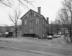 Easton Roller Mill |
December 19, 1978 (#78002806) |
Near Easton Hill on County Route 119/17 39°39′00″N 79°54′45″W |
Morgantown | |
| 10 | Ford House |  Ford House |
November 15, 1993 (#93001227) |
310 Ford St. 39°37′18″N 79°57′45″W |
Morgantown | |
| 11 | Fourth Ward School | _2.jpg.webp) Fourth Ward School |
August 25, 2004 (#04000914) |
287 Eureka Dr. 39°38′25″N 79°56′56″W |
Morgantown | |
| 12 | Greenmont Historic District | .jpg.webp) Greenmont Historic District |
February 2, 2005 (#04001597) |
Roughly bounded by Arlington, Front, Conn, White Ave., Posten Ave., Kingwood St., and Decker Ave. 39°37′31″N 79°57′00″W |
Morgantown | |
| 13 | Hackney House | 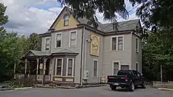 Hackney House |
July 1, 1999 (#99000789) |
89 Kingwood St. 39°37′39″N 79°57′08″W |
Morgantown | |
| 14 | Hamilton Farm Petroglyphs | 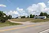 Hamilton Farm Petroglyphs |
August 7, 1974 (#74002015) |
Southeast of Ringgold on U.S. Route 119[6] 39°33′34″N 79°56′16″W |
Ringgold | |
| 15 | Harmony Grove Meeting House |  Harmony Grove Meeting House |
September 16, 1983 (#83003245) |
Off Interstate 79 39°36′12″N 79°59′25″W |
Harmony Grove | |
| 16 | Harner Homestead | 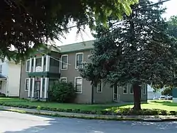 Harner Homestead |
January 12, 1984 (#84003629) |
1818 Listravia St. 39°37′26″N 79°55′14″W |
Morgantown | |
| 17 | Henry Clay Furnace | 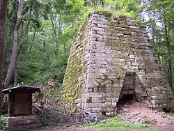 Henry Clay Furnace |
January 26, 1970 (#70000658) |
Southeast of Cheat Neck in Coopers Rock State Forest 39°38′56″N 79°49′07″W |
Cheat Neck | |
| 18 | Kern's Fort |  Kern's Fort |
April 9, 1993 (#93000225) |
305 Dewey St. 39°37′31″N 79°56′59″W |
Morgantown | |
| 19 | Kincaid and Arnett Feed and Flour Building | 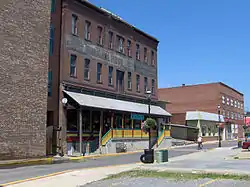 Kincaid and Arnett Feed and Flour Building |
July 21, 1995 (#95000873) |
156 Clay St. 39°37′31″N 79°57′50″W |
Morgantown | |
| 20 | Lynch Chapel United Methodist Church | 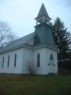 Lynch Chapel United Methodist Church |
November 15, 2006 (#06001046) |
Junction of County Routes 32 and 41 39°37′23″N 80°05′05″W |
Morgantown | |
| 21 | Mason and Dixon Survey Terminal Point |  Mason and Dixon Survey Terminal Point |
June 25, 1973 (#73001922) |
2.25 mi (3.62 km) northeast of Pentress on County Route 39 39°43′16″N 80°07′07″W |
Pentress | Extends into Perry Township in Greene County, Pennsylvania |
| 22 | Men's Hall | _WVU_Morgantown_WV.jpg.webp) Men's Hall |
February 5, 1990 (#89002309) |
Prospect and High Sts. 39°37′59″N 79°57′10″W |
Morgantown | |
| 23 | Metropolitan Theatre |  Metropolitan Theatre |
January 12, 1984 (#84003631) |
371 S. High St. 39°37′51″N 79°57′20″W |
Morgantown | |
| 24 | Monongalia County Courthouse | .jpg.webp) Monongalia County Courthouse |
July 8, 1985 (#85001525) |
243 High St. 39°37′47″N 79°57′26″W |
Morgantown | |
| 25 | Elizabeth Moore Hall | 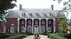 Elizabeth Moore Hall |
December 19, 1985 (#85003208) |
University Ave. 39°38′06″N 79°57′20″W |
Morgantown | |
| 26 | Morgantown Wharf and Warehouse Historic District |  Morgantown Wharf and Warehouse Historic District |
December 16, 1998 (#98001466) |
Roughly along the Monongahela River from Warren St. to Walnut St. 39°37′42″N 79°57′39″W |
Morgantown | |
| 27 | Oglebay Hall | 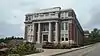 Oglebay Hall |
December 19, 1985 (#85003207) |
University Ave. 39°38′14″N 79°57′16″W |
Morgantown | |
| 28 | Old Morgantown Post Office | 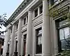 Old Morgantown Post Office |
March 28, 1979 (#79002593) |
107 High St. 39°37′41″N 79°57′29″W |
Morgantown | |
| 29 | Old Stone House |  Old Stone House |
December 27, 1972 (#72001290) |
Chestnut St. 39°37′50″N 79°57′24″W |
Morgantown | |
| 30 | Old Watson Homestead House | 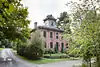 Old Watson Homestead House |
December 7, 1984 (#84003871) |
County Route 73 39°31′46″N 80°02′38″W |
Smithtown | |
| 31 | Purinton House | 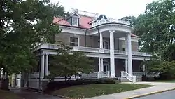 Purinton House |
December 19, 1985 (#85003206) |
University Ave. 39°38′05″N 79°57′20″W |
Morgantown | |
| 32 | Rogers House | _Morgantown_WV.jpg.webp) Rogers House |
December 4, 1984 (#84000683) |
293 Willey St. 39°37′53″N 79°57′09″W |
Morgantown | |
| 33 | St. Mary's Orthodox Church |  St. Mary's Orthodox Church |
February 3, 1988 (#87002525) |
W. Park and Holland Aves. 39°38′03″N 79°57′43″W |
Westover | |
| 34 | Second Ward Negro Elementary School | 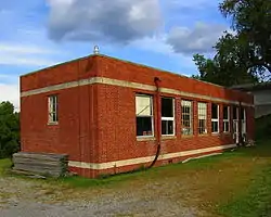 Second Ward Negro Elementary School |
July 28, 1992 (#92000896) |
Junction of White and Posten Aves. 39°37′17″N 79°56′57″W |
Morgantown | |
| 35 | Seneca Glass Company Building | 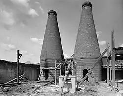 Seneca Glass Company Building |
December 19, 1985 (#85003214) |
709 Beechurst Ave. 39°38′28″N 79°57′44″W |
Morgantown | |
| 36 | South Park Historic District |  South Park Historic District |
July 23, 1990 (#90001054) |
Roughly bounded by Elgin St., Kingwood St., Cobun Ave., Prairie Ave., Jefferson St., Lincoln Ave., and Grand St. 39°37′21″N 79°57′08″W |
Morgantown | |
| 37 | Stalnaker Hall | 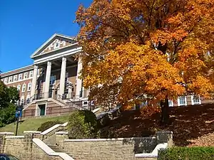 Stalnaker Hall |
December 19, 1985 (#85003205) |
Maiden Ln. 39°38′08″N 79°57′11″W |
Morgantown | |
| 38 | Stewart Hall | 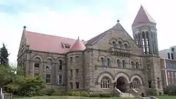 Stewart Hall |
June 25, 1980 (#80004034) |
West Virginia University campus 39°38′03″N 79°57′16″W |
Morgantown | |
| 39 | Vance Farmhouse |  Vance Farmhouse |
November 21, 1991 (#91001731) |
1535 Mileground, West Virginia University 39°38′23″N 79°56′13″W |
Morgantown | |
| 40 | Alexander Wade House | 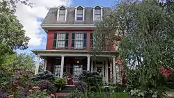 Alexander Wade House |
October 15, 1966 (#66000752) |
256 Prairie St. 39°37′29″N 79°57′30″W |
Morgantown | |
| 41 | Walters House | _front.jpg.webp) Walters House |
August 18, 1983 (#83003246) |
221 Willey St. 39°37′55″N 79°57′13″W |
Morgantown | |
| 42 | Waitman T. Willey House |  Waitman T. Willey House |
April 15, 1982 (#82004327) |
128 Wagner Rd. 39°37′30″N 79°57′34″W |
Morgantown | |
| 43 | Women's Christian Temperance Union Community Building |  Women's Christian Temperance Union Community Building |
October 30, 1985 (#85003406) |
160 Fayette St. 39°37′52″N 79°57′22″W |
Morgantown | |
| 44 | Woodburn Circle | 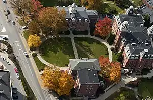 Woodburn Circle |
December 4, 1974 (#74002014) |
University Ave., West Virginia University 39°38′09″N 79°57′18″W |
Morgantown |
See also
| Wikimedia Commons has media related to National Register of Historic Places in Monongalia County, West Virginia. |
References
- The latitude and longitude information provided in this table was derived originally from the National Register Information System, which has been found to be fairly accurate for about 99% of listings. Some locations in this table may have been corrected to current GPS standards.
- "National Register of Historic Places: Weekly List Actions". National Park Service, United States Department of the Interior. Retrieved on January 29, 2021.
- Numbers represent an alphabetical ordering by significant words. Various colorings, defined here, differentiate National Historic Landmarks and historic districts from other NRHP buildings, structures, sites or objects.
- "National Register Information System". National Register of Historic Places. National Park Service. April 24, 2008.
- The eight-digit number below each date is the number assigned to each location in the National Register Information System database, which can be viewed by clicking the number.
- Coordinates derived from Swauger, James L. Rock Art of the Upper Ohio Valley. Graz: Akademische Druck und Verlagsanstalt, 1974, 115. The NRIS provides inaccurate coordinates.
| Topics | ||
|---|---|---|
| Lists by county |
| |
| Other lists | ||
| ||