National Register of Historic Places listings in Gilmer County, West Virginia
This is a list of the National Register of Historic Places listings in Gilmer County, West Virginia.
This is intended to be a complete list of the properties and districts on the National Register of Historic Places in Gilmer County, West Virginia, United States. The locations of National Register properties and districts for which the latitude and longitude coordinates are included below, may be seen in a Google map.[1]
There are 10 properties listed on the National Register in the county.
- This National Park Service list is complete through NPS recent listings posted January 29, 2021.[2]
Barbour - Berkeley - Boone - Braxton - Brooke - Cabell - Calhoun - Clay - Doddridge - Fayette - Gilmer - Grant - Greenbrier - Hampshire - Hancock - Hardy - Harrison - Jackson - Jefferson - Kanawha - Lewis - Lincoln - Logan - Marion - Marshall - Mason - McDowell - Mercer - Mineral - Mingo - Monongalia - Monroe - Morgan - Nicholas - Ohio - Pendleton - Pleasants - Pocahontas - Preston - Putnam - Raleigh - Randolph - Ritchie - Roane - Summers - Taylor - Tucker - Tyler - Upshur - Wayne - Webster - Wetzel - Wirt - Wood - Wyoming |
Current listings
| [3] | Name on the Register | Image | Date listed[4] | Location | City or town | Description |
|---|---|---|---|---|---|---|
| 1 | John E. Arbuckle House |  John E. Arbuckle House |
November 21, 1991 (#91001729) |
213 Court St. 38°56′06″N 80°50′07″W |
Glenville | |
| 2 | Cedarville School | 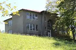 Cedarville School |
March 25, 1994 (#94000210) |
Junction of Smith Ave. and Edmond St. 38°50′25″N 80°49′08″W |
Cedarville | |
| 3 | Duck Run Cable Suspension Bridge | 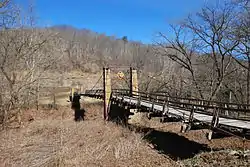 Duck Run Cable Suspension Bridge |
July 9, 1997 (#97000783) |
Over the Little Kanawha River south of the junction of WV 5 and County Route 30 38°55′42″N 80°47′14″W |
Trubada | |
| 4 | Gilmer County Poor Farm Infirmary |  Gilmer County Poor Farm Infirmary |
December 4, 1998 (#98001465) |
Off Sycamore Rd. on Recreation Center Rd. 38°57′08″N 80°49′46″W |
Glenville | |
| 5 | Glenville Truss Bridge | 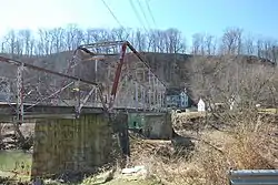 Glenville Truss Bridge |
December 4, 1998 (#98001477) |
Conrad Court over the Little Kanawha River 38°55′57″N 80°50′20″W |
Glenville | |
| 6 | Job's Temple | 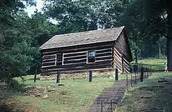 Job's Temple |
May 29, 1979 (#79002575) |
West of Glenville on WV 5 38°55′56″N 80°57′45″W |
Glenville | |
| 7 | Little Kanawha Valley Bank | 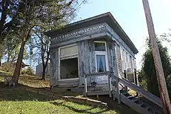 Little Kanawha Valley Bank |
August 5, 1991 (#91001012) |
5 Howard St. 38°56′02″N 80°50′11″W |
Glenville | |
| 8 | Ruddell General Store | 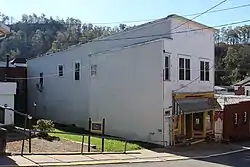 Ruddell General Store |
December 15, 1998 (#98001469) |
6 N. Court St. 38°56′02″N 80°50′13″W |
Glenville | |
| 9 | Stouts Mill Bridge | 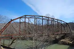 Stouts Mill Bridge |
December 4, 1998 (#98001476) |
Duskcamp Rd., over the Little Kanawha River 38°53′46″N 80°43′54″W |
Stouts Mill | |
| 10 | Whiting House |  Whiting House |
December 4, 1998 (#98001480) |
301 E. Main St. 38°55′57″N 80°50′10″W |
Glenville |
See also
| Wikimedia Commons has media related to National Register of Historic Places in Gilmer County, West Virginia. |
References
- The latitude and longitude information provided in this table was derived originally from the National Register Information System, which has been found to be fairly accurate for about 99% of listings. Some locations in this table may have been corrected to current GPS standards.
- "National Register of Historic Places: Weekly List Actions". National Park Service, United States Department of the Interior. Retrieved on January 29, 2021.
- Numbers represent an alphabetical ordering by significant words. Various colorings, defined here, differentiate National Historic Landmarks and historic districts from other NRHP buildings, structures, sites or objects.
- The eight-digit number below each date is the number assigned to each location in the National Register Information System database, which can be viewed by clicking the number.
| Topics | ||
|---|---|---|
| Lists by county |
| |
| Other lists | ||
| ||
Municipalities and communities of Gilmer County, West Virginia, United States | ||
|---|---|---|
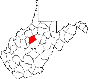
| Towns | Map of West Virginia highlighting Gilmer County | |
| Unincorporated communities | ||
| Footnotes | ‡This populated place also has portions in an adjacent county or counties | |
| ||