National Register of Historic Places listings in Mingo County, West Virginia
This is a list of the National Register of Historic Places listings in Mingo County, West Virginia.
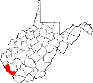
This is intended to be a complete list of the properties and districts on the National Register of Historic Places in Mingo County, West Virginia, United States. The locations of National Register properties and districts for which the latitude and longitude coordinates are included below, may be seen in a Google map.[1]
There are 8 properties and districts listed on the National Register in the county.
- This National Park Service list is complete through NPS recent listings posted February 5, 2021.[2]
Barbour - Berkeley - Boone - Braxton - Brooke - Cabell - Calhoun - Clay - Doddridge - Fayette - Gilmer - Grant - Greenbrier - Hampshire - Hancock - Hardy - Harrison - Jackson - Jefferson - Kanawha - Lewis - Lincoln - Logan - Marion - Marshall - Mason - McDowell - Mercer - Mineral - Mingo - Monongalia - Monroe - Morgan - Nicholas - Ohio - Pendleton - Pleasants - Pocahontas - Preston - Putnam - Raleigh - Randolph - Ritchie - Roane - Summers - Taylor - Tucker - Tyler - Upshur - Wayne - Webster - Wetzel - Wirt - Wood - Wyoming |
Current listings
| [3] | Name on the Register[4] | Image | Date listed[5] | Location | City or town | Description |
|---|---|---|---|---|---|---|
| 1 | Coal House | 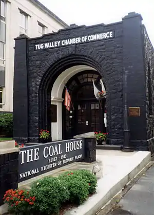 Coal House |
March 6, 1980 (#80004297) |
2nd Ave. and Court St. 37°40′19″N 82°16′40″W |
Williamson | |
| 2 | Hatfield Cemetery | November 28, 1980 (#80004033) |
South of Newtown on County Route 6 37°37′59″N 82°05′39″W |
Newtown | ||
| 3 | Matewan Historic District | 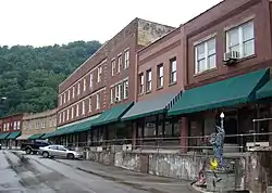 Matewan Historic District |
April 27, 1993 (#93000303) |
Roughly bounded by McCoy Alley, Railroad Alley, Mate St. underpass and Warm Hollow to the head of the hollow 37°37′21″N 82°09′55″W |
Matewan | |
| 4 | Mountaineer Hotel | 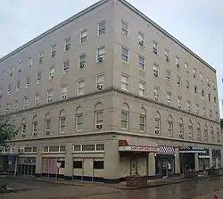 Mountaineer Hotel |
March 21, 1997 (#97000265) |
31 E. 2nd Ave. 37°40′24″N 82°16′42″W |
Williamson | |
| 5 | R. T. Price House | January 10, 1991 (#90001989) |
2405 W. Third Ave. 37°40′36″N 82°18′05″W |
Williamson | ||
| 6 | Elven C. Smith House | August 22, 2002 (#02000899) |
210 Little Oak St. 37°40′39″N 82°16′39″W |
Williamson | ||
| 7 | Williamson Field House | December 15, 2011 (#11000930) |
1703 W. 3rd Ave. 37°40′40″N 82°17′32″W |
Williamson | ||
| 8 | Williamson Historic District |  Williamson Historic District |
November 15, 2006 (#06001045) |
Roughly bounded by the Norfold & Western railroad line, Pritchard, Popular, Park, Mulberry and Elm Sts. 37°40′31″N 82°16′30″W |
Williamson |
See also
| Wikimedia Commons has media related to National Register of Historic Places in Mingo County, West Virginia. |
References
- The latitude and longitude information provided in this table was derived originally from the National Register Information System, which has been found to be fairly accurate for about 99% of listings. Some locations in this table may have been corrected to current GPS standards.
- "National Register of Historic Places: Weekly List Actions". National Park Service, United States Department of the Interior. Retrieved on February 5, 2021.
- Numbers represent an alphabetical ordering by significant words. Various colorings, defined here, differentiate National Historic Landmarks and historic districts from other NRHP buildings, structures, sites or objects.
- "National Register Information System". National Register of Historic Places. National Park Service. April 24, 2008.
- The eight-digit number below each date is the number assigned to each location in the National Register Information System database, which can be viewed by clicking the number.
| Topics | ||
|---|---|---|
| Lists by county |
| |
| Other lists | ||
| ||
Municipalities and communities of Mingo County, West Virginia, United States | ||
|---|---|---|
| City | Mingo County map | |
| Towns | ||
| CDPs | ||
| Other communities |
| |
| Footnotes | ‡This populated place also has portions in an adjacent county or counties | |
| ||