National Register of Historic Places listings in Tyler County, West Virginia
This is a list of the National Register of Historic Places listings in Tyler County, West Virginia.
This is intended to be a complete list of the properties and districts on the National Register of Historic Places in Tyler County, West Virginia, United States. The locations of National Register properties and districts for which the latitude and longitude coordinates are included below, may be seen in a Google map.[1]
There are 10 properties and districts listed on the National Register in the county.
- This National Park Service list is complete through NPS recent listings posted January 29, 2021.[2]
Barbour - Berkeley - Boone - Braxton - Brooke - Cabell - Calhoun - Clay - Doddridge - Fayette - Gilmer - Grant - Greenbrier - Hampshire - Hancock - Hardy - Harrison - Jackson - Jefferson - Kanawha - Lewis - Lincoln - Logan - Marion - Marshall - Mason - McDowell - Mercer - Mineral - Mingo - Monongalia - Monroe - Morgan - Nicholas - Ohio - Pendleton - Pleasants - Pocahontas - Preston - Putnam - Raleigh - Randolph - Ritchie - Roane - Summers - Taylor - Tucker - Tyler - Upshur - Wayne - Webster - Wetzel - Wirt - Wood - Wyoming |
Current listings
| [3] | Name on the Register | Image | Date listed[4] | Location | City or town | Description |
|---|---|---|---|---|---|---|
| 1 | E. A. Durham House |  E. A. Durham House |
June 19, 1973 (#73001924) |
110 Chelsea St. 39°33′06″N 81°00′02″W |
Sistersville | |
| 2 | Friendly City Building and Jail |  Friendly City Building and Jail |
November 22, 1999 (#99001404) |
WV 2, Orchard St. 39°30′55″N 81°03′35″W |
Friendly | |
| 3 | Middlebourne Historic District |  Middlebourne Historic District |
July 9, 1993 (#93000613) |
Main, East, and Dodd Sts. 39°29′34″N 80°54′38″W |
Middlebourne | |
| 4 | Sistersville City Hall |  Sistersville City Hall |
October 5, 1972 (#72001292) |
City Sq., Main and Diamond Sts. 39°33′53″N 80°59′47″W |
Sistersville | |
| 5 | Sistersville Historic District |  Sistersville Historic District |
August 13, 1975 (#75001899) |
From Chelsea to the Ohio River between Catherine and both sides of Virginia Sts. 39°33′55″N 80°59′45″W |
Sistersville | |
| 6 | Tyler County Courthouse and Jail | 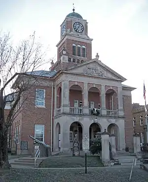 Tyler County Courthouse and Jail |
June 23, 1980 (#80004044) |
Main and Dodd Sts. 39°29′31″N 80°54′14″W |
Middlebourne | |
| 7 | Wells Inn |  Wells Inn |
October 5, 1972 (#72001293) |
316 Charles St. 39°33′48″N 80°59′55″W |
Sistersville | |
| 8 | William Wells House | July 21, 1987 (#87001176) |
WV 18 39°26′05″N 80°49′28″W |
Tyler | ||
| 9 | Wells-Schaff House |  Wells-Schaff House |
January 7, 1986 (#86000054) |
500 S. Wells 39°33′26″N 81°00′19″W |
Sistersville | |
| 10 | Wells-Twyford House | April 29, 1991 (#91000447) |
Junction of WV 2 and Kahle St. 39°32′57″N 81°00′50″W |
Sistersville |
See also
| Wikimedia Commons has media related to National Register of Historic Places in Tyler County, West Virginia. |
References
- The latitude and longitude information provided in this table was derived originally from the National Register Information System, which has been found to be fairly accurate for about 99% of listings. Some locations in this table may have been corrected to current GPS standards.
- "National Register of Historic Places: Weekly List Actions". National Park Service, United States Department of the Interior. Retrieved on January 29, 2021.
- Numbers represent an alphabetical ordering by significant words. Various colorings, defined here, differentiate National Historic Landmarks and historic districts from other NRHP buildings, structures, sites or objects.
- The eight-digit number below each date is the number assigned to each location in the National Register Information System database, which can be viewed by clicking the number.
| Topics | ||
|---|---|---|
| Lists by county |
| |
| Other lists | ||
| ||
Municipalities and communities of Tyler County, West Virginia, United States | ||
|---|---|---|
| Cities | Tyler County map | |
| Towns | ||
| Unincorporated communities | ||
| Footnotes | ‡This populated place also has portions in an adjacent county or counties | |
| ||