National Register of Historic Places listings in Pocahontas County, West Virginia
This is a list of the National Register of Historic Places listings in Pocahontas County, West Virginia.
This is intended to be a complete list of the properties and districts on the National Register of Historic Places in Pocahontas County, West Virginia, United States. The locations of National Register properties and districts for which the latitude and longitude coordinates are included below, may be seen in an online map.[1]
There are 22 properties and districts listed on the National Register in the county, 1 of which is a National Historic Landmark.
- This National Park Service list is complete through NPS recent listings posted January 29, 2021.[2]
Barbour - Berkeley - Boone - Braxton - Brooke - Cabell - Calhoun - Clay - Doddridge - Fayette - Gilmer - Grant - Greenbrier - Hampshire - Hancock - Hardy - Harrison - Jackson - Jefferson - Kanawha - Lewis - Lincoln - Logan - Marion - Marshall - Mason - McDowell - Mercer - Mineral - Mingo - Monongalia - Monroe - Morgan - Nicholas - Ohio - Pendleton - Pleasants - Pocahontas - Preston - Putnam - Raleigh - Randolph - Ritchie - Roane - Summers - Taylor - Tucker - Tyler - Upshur - Wayne - Webster - Wetzel - Wirt - Wood - Wyoming |
Current listings
| [3] | Name on the Register[4] | Image | Date listed[5] | Location | City or town | Description |
|---|---|---|---|---|---|---|
| 1 | Richard Beard House | March 20, 2002 (#02000255) |
Off County Road 31 on Kyle Beard Rd. 38°05′16″N 80°14′15″W |
Hillsboro | ||
| 2 | Pearl Buck House | 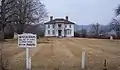 Pearl Buck House |
June 15, 1970 (#70000663) |
8129 Seneca Trail (U.S. Route 219) 38°08′30″N 80°12′19″W |
Hillsboro | |
| 3 | Camp Allegheny |  Camp Allegheny |
September 28, 1990 (#90001446) |
County Route 3, just east of County Route 5 at Top of Allegheny[6] 38°28′26″N 79°43′28″W |
Bartow | |
| 4 | Camp Bartow Historic District | 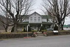 Camp Bartow Historic District |
May 10, 1996 (#95001325) |
Junction of U.S. Route 250 and West Virginia Routes 28 and 92 38°32′03″N 79°46′04″W |
Bartow | |
| 5 | Cass Historic District |  Cass Historic District |
November 28, 1980 (#80004038) |
WV 66 and County Route 1 38°23′29″N 79°55′08″W |
Cass | |
| 6 | Cass Scenic Railroad |  Cass Scenic Railroad |
July 12, 1974 (#74002019) |
Along railroad tracks from Cass to Bald Knob 38°25′58″N 79°56′14″W |
Cass | |
| 7 | Droop Mountain Battlefield | 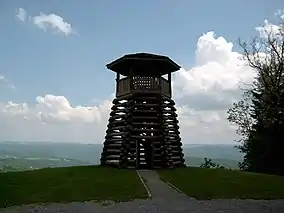 Droop Mountain Battlefield |
January 26, 1970 (#70000664) |
About 14 miles south of Marlinton on U.S. Route 219 38°06′36″N 80°16′20″W |
Marlinton | |
| 8 | GW Jeep Site |  GW Jeep Site |
December 23, 1993 (#93001443) |
Elleber Sods Rd.[7] 38°24′55″N 79°42′27″W |
Greenbank | Extends into Highland County, Virginia |
| 9 | Frank and Anna Hunter House |  Frank and Anna Hunter House |
May 13, 1976 (#76001945) |
U.S. Route 219 38°13′14″N 80°06′03″W |
Marlinton | |
| 10 | Huntersville Presbyterian Church | 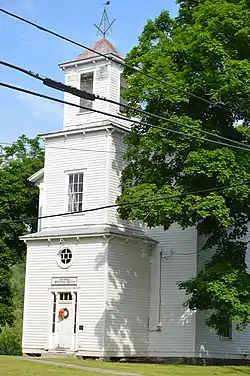 Huntersville Presbyterian Church |
October 4, 1978 (#78002809) |
County Route 21 at WV 39 38°11′24″N 80°01′04″W |
Huntersville | |
| 11 | IOOF Lodge Building | 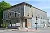 IOOF Lodge Building |
March 24, 2000 (#00000249) |
Junction of 8th St. and Second Ave. 38°13′25″N 80°05′40″W |
Marlinton | |
| 12 | Locust Creek Covered Bridge | 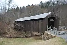 Locust Creek Covered Bridge |
June 4, 1981 (#81000607) |
County Route 31 at County Route 20 38°04′46″N 80°15′01″W |
Hillsboro | |
| 13 | Marlinton Chesapeake and Ohio Railroad Station |  Marlinton Chesapeake and Ohio Railroad Station |
August 29, 1979 (#79002598) |
8th St. and 4th Ave. 38°13′21″N 80°05′34″W |
Marlinton | Destroyed by fire[8] |
| 14 | Marlinton Opera House | 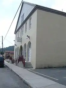 Marlinton Opera House |
March 24, 2000 (#00000253) |
Third Ave. 38°13′21″N 80°05′41″W |
Marlinton | |
| 15 | McNeel Mill | 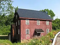 McNeel Mill |
August 8, 1985 (#85001783) |
U.S. Route 219 38°09′26″N 80°10′55″W |
Mill Point | |
| 16 | New Deal Resources in Seneca State Forest Historic District | New Deal Resources in Seneca State Forest Historic District |
September 4, 2018 (#100002854) |
10135 Browns Creek Rd. 38°17′47″N 79°55′42″W |
Dunmore | |
| 16 | New Deal Resources in Watoga State Park Historic District | 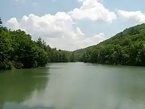 New Deal Resources in Watoga State Park Historic District |
February 4, 2011 (#10001227) |
HC 82 (9 miles southwest of WV 39) 38°07′01″N 80°07′41″W |
Marlinton | |
| 17 | Pleasant Green Methodist Episcopal Church | 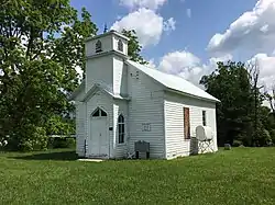 Pleasant Green Methodist Episcopal Church |
December 12, 2012 (#12001052) |
Seebert Rd. 38°08′30″N 80°11′23″W |
Seebert | |
| 18 | Pocahontas County Courthouse and Jail |  Pocahontas County Courthouse and Jail |
July 15, 1994 (#94000724) |
900C Tenth Ave. 38°13′04″N 80°05′18″W |
Marlinton | |
| 19 | Pocahontas Times Print Shop | 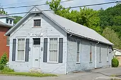 Pocahontas Times Print Shop |
September 22, 1977 (#77001379) |
810 2nd Ave. 38°13′23″N 80°05′42″W |
Marlinton | |
| 20 | Reber Radio Telescope |  Reber Radio Telescope |
November 9, 1972 (#72001291) |
Green Bank Observatory, northeast of Green Bank on WV 28/WV 92 38°25′49″N 79°49′04″W |
Green Bank | |
| 21 | Seebert Lane Colored School | December 12, 2012 (#12001053) |
Seebert Rd. 38°08′47″N 80°11′39″W |
Seebert |
See also
| Wikimedia Commons has media related to National Register of Historic Places in Pocahontas County, West Virginia. |
References
- The latitude and longitude information provided in this table was derived originally from the National Register Information System, which has been found to be fairly accurate for about 99% of listings. Some locations in this table may have been corrected to current GPS standards.
- "National Register of Historic Places: Weekly List Actions". National Park Service, United States Department of the Interior. Retrieved on January 29, 2021.
- Numbers represent an alphabetical ordering by significant words. Various colorings, defined here, differentiate National Historic Landmarks and historic districts from other NRHP buildings, structures, sites or objects.
- "National Register Information System". National Register of Historic Places. National Park Service. April 24, 2008.
- The eight-digit number below each date is the number assigned to each location in the National Register Information System database, which can be viewed by clicking the number.
- Monongahela National Forest (Map). 1:126,720. Monongahela National Forest. 2007. ISBN 978-1-59351-857-8.
- Brinker, Ruth. National Register of Historic Places Inventory-Nomination Form: GW Jeep Site. National Park Service, 1992-08-31, 9.
- Grimes, Cathy; Stewart, Suzanne (2008-03-29). "Fire Destroys Marlinton Depot". The Inter-Mountain. Archived from the original on 2009-01-18. Retrieved 2009-01-18.
| Topics | ||
|---|---|---|
| Lists by county |
| |
| Other lists | ||
| ||
Municipalities and communities of Pocahontas County, West Virginia, United States | ||
|---|---|---|
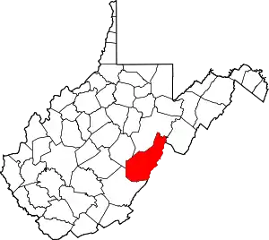
| Towns | Map of West Virginia highlighting Pocahontas County | |
| CDPs | ||
| Unincorporated communities |
| |
| Ghost towns | ||
| ||