National Register of Historic Places listings in Cabell County, West Virginia
This is a list of the National Register of Historic Places listings in Cabell County, West Virginia.
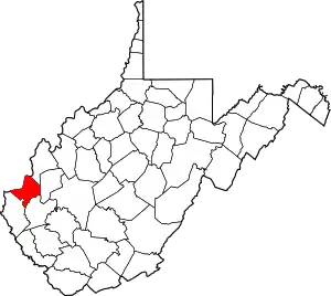
This is intended to be a complete list of the properties and districts on the National Register of Historic Places in Cabell County, West Virginia. The locations of National Register properties and districts for which the latitude and longitude coordinates are included below, may be seen in an online map.[1]
There are 39 properties and districts listed on the National Register in the county, 1 of which is a National Historic Landmark.
- This National Park Service list is complete through NPS recent listings posted January 29, 2021.[2]
Barbour - Berkeley - Boone - Braxton - Brooke - Cabell - Calhoun - Clay - Doddridge - Fayette - Gilmer - Grant - Greenbrier - Hampshire - Hancock - Hardy - Harrison - Jackson - Jefferson - Kanawha - Lewis - Lincoln - Logan - Marion - Marshall - Mason - McDowell - Mercer - Mineral - Mingo - Monongalia - Monroe - Morgan - Nicholas - Ohio - Pendleton - Pleasants - Pocahontas - Preston - Putnam - Raleigh - Randolph - Ritchie - Roane - Summers - Taylor - Tucker - Tyler - Upshur - Wayne - Webster - Wetzel - Wirt - Wood - Wyoming |
Current listings
| [3] | Name on the Register | Image | Date listed[4] | Location | City or town | Description |
|---|---|---|---|---|---|---|
| 1 | Baltimore and Ohio Railroad Depot |  Baltimore and Ohio Railroad Depot |
October 30, 1973 (#73001897) |
1100 block of Veterans Memorial Boulevard 38°25′24″N 82°26′33″W |
Huntington | |
| 2 | Barboursville Historic District | 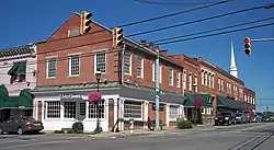 Barboursville Historic District |
December 24, 2008 (#08001234) |
Water, Main, and Brady Sts. and Central Ave. 38°24′35″N 82°17′42″W |
Barboursville | |
| 3 | Barnett Hospital and Nursing School | 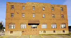 Barnett Hospital and Nursing School |
December 30, 2009 (#09001190) |
1201 7th Ave. 38°25′03″N 82°26′15″W |
Huntington | |
| 4 | Cabell County Courthouse | 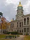 Cabell County Courthouse |
September 2, 1982 (#82004313) |
5th Ave. and 8th St. 38°25′11″N 82°26′47″W |
Huntington | |
| 5 | Campbell-Hicks House | 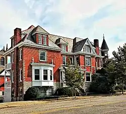 Campbell-Hicks House |
August 19, 1985 (#85001814) |
1102 5th Ave. 38°25′12″N 82°26′21″W |
Huntington | |
| 6 | Carnegie Public Library | 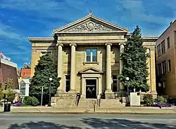 Carnegie Public Library |
April 3, 1980 (#80004015) |
900 5th Ave. 38°25′11″N 82°26′36″W |
Huntington | |
| 7 | Thomas Carroll House | 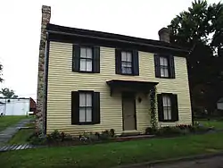 Thomas Carroll House |
June 1, 1973 (#73001898) |
234 Guyan St. 38°25′44″N 82°23′24″W |
Huntington | |
| 8 | Chesapeake and Ohio 1308 Steam Locomotive | 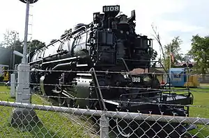 Chesapeake and Ohio 1308 Steam Locomotive |
January 31, 2003 (#02001571) |
1401 Memorial Boulevard 38°24′19″N 82°28′38″W |
Huntington | |
| 9 | Clover Site | 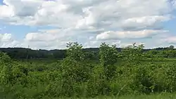 Clover Site |
April 27, 1992 (#92001881) |
20 miles (32 km) above Huntington in the Green Bottom Wildlife Management Area[5] 38°35′24″N 82°13′54″W |
Lesage | Fields along and above the Ohio River; a major Fort Ancient-period village site[6] |
| 10 | Douglass Junior and Senior High School |  Douglass Junior and Senior High School |
December 5, 1985 (#85003091) |
10th Ave. and Bruce St. 38°24′52″N 82°25′53″W |
Huntington | |
| 11 | Downtown Huntington Historic District |  Downtown Huntington Historic District |
February 24, 1986 (#86000309) |
Roughly bounded by 3rd Ave., 10th St., 5th Ave., and 7th and 8th Sts.; also portions of 3rd Ave. to the alley between 6th and 7th Aves. and from 12th St. to 7th St. 38°25′02″N 82°26′11″W |
Huntington | Second set of boundaries represents a boundary increase of March 22, 2007 |
| 12 | Elk River Coal and Lumber Company No. 10 Steam Locomotive | Elk River Coal and Lumber Company No. 10 Steam Locomotive |
September 28, 2006 (#06000901) |
Junction of Veterans Memorial Boulevard and 11th St. 38°25′25″N 82°26′27″W |
Huntington | |
| 13 | Foster Memorial Home | 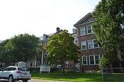 Foster Memorial Home |
February 27, 2001 (#00001311) |
700 Madison Ave. 38°24′46″N 82°28′01″W |
Huntington | |
| 14 | Freeman Estate | April 23, 2009 (#09000243) |
1805 McCoy Rd. 38°24′02″N 82°26′10″W |
Huntington | ||
| 15 | Memphis Tennessee Garrison House | January 23, 2017 (#100000573) |
1701 10th Ave. 38°24′56″N 82°25′33″W |
Huntington | ||
| 16 | Harvey House |  Harvey House |
August 21, 1972 (#72001285) |
1305 3rd Ave. 38°25′24″N 82°26′15″W |
Huntington | |
| 17 | Hawthorne Historic District | August 2, 2007 (#07000786) |
Roughly Hawthorne Way and portions of S. Whitaker Boulevard 38°24′22″N 82°26′39″W |
Huntington | ||
| 18 | Huntington High School | .jpg.webp) Huntington High School |
April 4, 2000 (#00000248) |
900 8th St. 38°24′49″N 82°26′36″W |
Huntington | |
| 19 | Gen. Albert Gallatin Jenkins House | 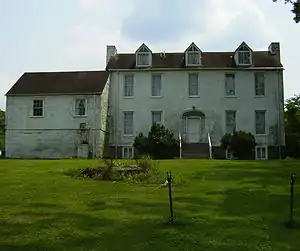 Gen. Albert Gallatin Jenkins House |
May 22, 1978 (#78002791) |
8814 Ohio River Rd. 38°35′12″N 82°14′58″W |
Green Bottom | |
| 20 | Johnston-Meek House |  Johnston-Meek House |
April 14, 2004 (#04000313) |
203 6th Ave. 38°24′56″N 82°27′17″W |
Huntington | |
| 21 | Kenwood | August 2, 2007 (#07000784) |
619 Ridgewood Rd. 38°24′10″N 82°26′43″W |
Huntington | ||
| 22 | Liggett and Myers Tobacco Company | 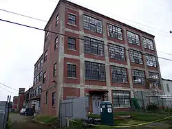 Liggett and Myers Tobacco Company |
August 14, 1998 (#98001073) |
9 27th St. 38°26′02″N 82°24′33″W |
Huntington | |
| 23 | Masonic Temple-Watts, Ritter, Wholesale Drygoods Company Building | 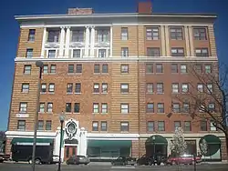 Masonic Temple-Watts, Ritter, Wholesale Drygoods Company Building |
August 26, 1993 (#93000614) |
1100-1108 E. 3rd Ave. 38°25′22″N 82°26′28″W |
Huntington | |
| 24 | Memorial Arch | Memorial Arch |
April 16, 1981 (#81000597) |
Memorial Park 38°24′23″N 82°27′46″W |
Huntington | |
| 25 | Morris Memorial Hospital for Crippled Children | May 8, 2013 (#13000262) |
Morris Memorial Rd. between the James River Turnpike and U.S. Route 60 38°25′14″N 82°06′28″W |
Milton | ||
| 26 | Mortimer Place Historic District | 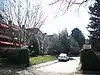 Mortimer Place Historic District |
March 12, 2001 (#01000266) |
Bounded by an alley, 10th St., 12th Ave., and 11th St. 38°24′35″N 82°26′17″W |
Huntington | |
| 27 | Mud River Covered Bridge | 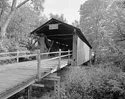 Mud River Covered Bridge |
June 10, 1975 (#75001883) |
Off U.S. Route 60 on County Route 25 over the Mud River 38°25′51″N 82°08′22″W |
Milton | |
| 28 | Ninth Street West Historic District | 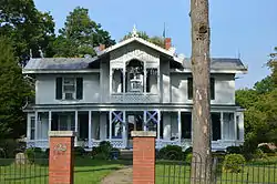 Ninth Street West Historic District |
November 28, 1980 (#80004016) |
9th St. West and Madison and Jefferson Aves. 38°24′44″N 82°28′14″W |
Huntington | |
| 29 | Ohev Sholom Temple | 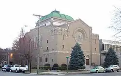 Ohev Sholom Temple |
March 17, 1994 (#94000211) |
949 10th Ave. 38°24′44″N 82°26′24″W |
Huntington | |
| 30 | Old Main, Marshall University |  Old Main, Marshall University |
July 16, 1973 (#73001899) |
Hal Greer Boulevard on the Marshall University campus 38°25′23″N 82°25′47″W |
Huntington | |
| 31 | Prichard House |  Prichard House |
March 12, 2001 (#01000261) |
500 12th Ave. 38°24′31″N 82°26′51″W |
Huntington | |
| 32 | Ricketts House | 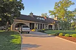 Ricketts House |
July 15, 1994 (#94000721) |
2301 Washington Boulevard 38°24′21″N 82°24′44″W |
Huntington | |
| 33 | Ritter Park Historic District |  Ritter Park Historic District |
November 28, 1990 (#90001774) |
Ritter Park, including northern boundary streets 38°24′15″N 82°26′16″W |
Huntington | |
| 34 | Rotary Park Bridge | 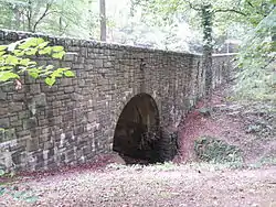 Rotary Park Bridge |
December 12, 2002 (#02001525) |
Rotary Park, 31 St., and Rotary Dr. 38°25′07″N 82°23′39″W |
Huntington | |
| 35 | Simms School Building | 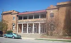 Simms School Building |
May 12, 1997 (#96000438) |
1680 11th Ave. 38°24′50″N 82°25′34″W |
Huntington | |
| 36 | Thornburg House | 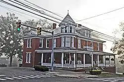 Thornburg House |
April 25, 1991 (#91000451) |
700 Main St. 38°24′35″N 82°17′40″W |
Barboursville | |
| 37 | U.S. Post Office and Courthouse | 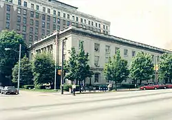 U.S. Post Office and Courthouse |
April 15, 1982 (#82004314) |
845 5th Ave.[7] 38°25′08″N 82°26′38″W |
Huntington | |
| 38 | Zachary Taylor Wellington House | 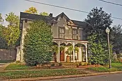 Zachary Taylor Wellington House |
December 24, 2008 (#08001235) |
415 Main St. 38°25′29″N 82°23′23″W |
Huntington | |
| 39 | West Virginia Colored Children's Home |  West Virginia Colored Children's Home |
November 13, 1997 (#97001413) |
3353 U.S. Route 60 38°24′34″N 82°22′25″W |
Huntington | Demolished on May 5, 2011 to make room for a new middle school.[8][9] |
See also
| Wikimedia Commons has media related to National Register of Historic Places in Cabell County, West Virginia. |
References
- The latitude and longitude information provided in this table was derived originally from the National Register Information System, which has been found to be fairly accurate for about 99% of listings. Some locations in this table may have been corrected to current GPS standards.
- "National Register of Historic Places: Weekly List Actions". National Park Service, United States Department of the Interior. Retrieved on January 29, 2021.
- Numbers represent an alphabetical ordering by significant words. Various colorings, defined here, differentiate National Historic Landmarks and historic districts from other NRHP buildings, structures, sites or objects.
- The eight-digit number below each date is the number assigned to each location in the National Register Information System database, which can be viewed by clicking the number.
- Maslowski, Robert F. "Clover Archeological Site". The West Virginia Encyclopedia, 2013-03-15. Accessed 2013-08-10.
- Maslowski, Robert F. National Register of Historic Places Inventory/Nomination: Clover Site. National Park Service, 1991-11-16, 9.
- "Huntington". United States District Court — Southern District of West Virginia. Retrieved April 12, 2016.
- http://www.herald-dispatch.com/news/briefs/x1411939090/Cabell-school-officials-ready-to-mitigate-loss-of-old-orphanage
- Herald-Dispatch.com, Huntongton, WV, May 6, 2011
| Topics | ||
|---|---|---|
| Lists by county |
| |
| Other lists | ||
| ||
Municipalities and communities of Cabell County, West Virginia, United States | ||
|---|---|---|
| City | Cabell County map | |
| Town | ||
| Village | ||
| CDPs | ||
| Other communities | ||
| Footnotes | ‡This populated place also has portions in an adjacent county or counties | |
| ||