National Register of Historic Places listings in Jackson County, West Virginia
This is a list of the National Register of Historic Places listings in Jackson County, West Virginia.
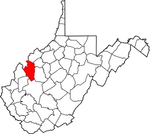
This is intended to be a complete list of the properties and districts on the National Register of Historic Places in Jackson County, West Virginia, United States. The locations of National Register properties and districts for which the latitude and longitude coordinates are included below, may be seen in a Google map.[1]
There are 10 properties and districts listed on the National Register in the county. Another property was once listed but has been removed.
- This National Park Service list is complete through NPS recent listings posted January 29, 2021.[2]
Barbour - Berkeley - Boone - Braxton - Brooke - Cabell - Calhoun - Clay - Doddridge - Fayette - Gilmer - Grant - Greenbrier - Hampshire - Hancock - Hardy - Harrison - Jackson - Jefferson - Kanawha - Lewis - Lincoln - Logan - Marion - Marshall - Mason - McDowell - Mercer - Mineral - Mingo - Monongalia - Monroe - Morgan - Nicholas - Ohio - Pendleton - Pleasants - Pocahontas - Preston - Putnam - Raleigh - Randolph - Ritchie - Roane - Summers - Taylor - Tucker - Tyler - Upshur - Wayne - Webster - Wetzel - Wirt - Wood - Wyoming |
Current listings
| [3] | Name on the Register | Image | Date listed[4] | Location | City or town | Description |
|---|---|---|---|---|---|---|
| 1 | Armstrong House |  Armstrong House |
February 12, 1980 (#80004023) |
315 North St. 38°49′12″N 81°42′51″W |
Ripley | |
| 2 | Clerc-Carson House | 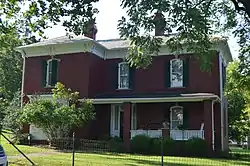 Clerc-Carson House |
October 29, 1992 (#92001482) |
121 North St. 38°49′10″N 81°42′31″W |
Ripley | |
| 3 | Faber Double-Crib Barn | September 7, 2005 (#05001007) |
1106 County Route 21 38°37′14″N 81°39′57″W |
Kenna | ||
| 4 | Lemley-Wood-Sayer House |  Lemley-Wood-Sayer House |
October 30, 1985 (#85003409) |
301 Walnut St. 38°56′55″N 81°45′36″W |
Ravenswood | |
| 5 | Otterbein Church | April 1, 1998 (#98000286) |
County Route 87/11, near junction with County Route 5 38°49′54″N 81°47′36″W |
Evans | ||
| 6 | Rankin Octagonal Barn |  Rankin Octagonal Barn |
July 9, 1985 (#85001551) |
County Route 3 38°56′45″N 81°41′44″W |
Silverton | |
| 7 | Ravenswood "Old Town" Historic District |  Ravenswood "Old Town" Historic District |
March 23, 2007 (#07000243) |
Bounded by Sandy Creek, the Ohio River, Sycamore St., and adjoining properties and the city limits to the east 38°56′53″N 81°45′39″W |
Ravenswood | |
| 8 | Ripley Historic District | 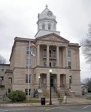 Ripley Historic District |
August 25, 2004 (#04000919) |
Portions of Charleston and Highlawn Drs., Church, Court, Main, Maple, North, 7th, and South Sts. 38°49′10″N 81°42′36″W |
Ripley | |
| 9 | Sarvis Fork Covered Bridge |  Sarvis Fork Covered Bridge |
June 4, 1981 (#81000602) |
County Route 21/15 38°55′17″N 81°38′41″W |
Sandyville | |
| 10 | Staats Mill Covered Bridge | 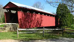 Staats Mill Covered Bridge |
May 29, 1979 (#79002582) |
Off County Route 25 at Cedar Lakes 38°47′40″N 81°41′14″W |
Ripley |
Former listing
| [3] | Name on the Register | Image | Date listed | Date removed | Location | City or town | Summary |
|---|---|---|---|---|---|---|---|
| 1 | Old Ravenswood School | August 29, 1979 (#79002581) | April 16, 1984 | Henry St. 38°56′54″N 81°45′24″W |
Ravenswood | [5] |
See also
| Wikimedia Commons has media related to National Register of Historic Places in Jackson County, West Virginia. |
References
- The latitude and longitude information provided in this table was derived originally from the National Register Information System, which has been found to be fairly accurate for about 99% of listings. Some locations in this table may have been corrected to current GPS standards.
- "National Register of Historic Places: Weekly List Actions". National Park Service, United States Department of the Interior. Retrieved on January 29, 2021.
- Numbers represent an alphabetical ordering by significant words. Various colorings, defined here, differentiate National Historic Landmarks and historic districts from other NRHP buildings, structures, sites or objects.
- The eight-digit number below each date is the number assigned to each location in the National Register Information System database, which can be viewed by clicking the number.
- West Virginia Division of Culture and History: Jackson County NRHP listings
| Topics | ||
|---|---|---|
| Lists by county |
| |
| Other lists | ||
| ||