National Register of Historic Places listings in Harrison County, West Virginia
This is a list of the National Register of Historic Places listings in Harrison County, West Virginia.
This is intended to be a complete list of the properties and districts on the National Register of Historic Places in Harrison County, West Virginia, United States. The locations of National Register properties and districts for which the latitude and longitude coordinates are included below, may be seen in a Google map.[1]
There are 21 properties and districts listed on the National Register in the county. Another property was once listed but has been removed.
- This National Park Service list is complete through NPS recent listings posted January 29, 2021.[2]
Barbour - Berkeley - Boone - Braxton - Brooke - Cabell - Calhoun - Clay - Doddridge - Fayette - Gilmer - Grant - Greenbrier - Hampshire - Hancock - Hardy - Harrison - Jackson - Jefferson - Kanawha - Lewis - Lincoln - Logan - Marion - Marshall - Mason - McDowell - Mercer - Mineral - Mingo - Monongalia - Monroe - Morgan - Nicholas - Ohio - Pendleton - Pleasants - Pocahontas - Preston - Putnam - Raleigh - Randolph - Ritchie - Roane - Summers - Taylor - Tucker - Tyler - Upshur - Wayne - Webster - Wetzel - Wirt - Wood - Wyoming |
Current listings
| [3] | Name on the Register | Image | Date listed[4] | Location | City or town | Description |
|---|---|---|---|---|---|---|
| 1 | Daniel Bassel House | 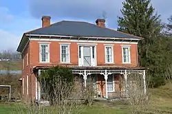 Daniel Bassel House |
August 22, 2002 (#02000898) |
County Route 25, south of its junction with WV 270 39°09′40″N 80°21′11″W |
Lost Creek | |
| 2 | Bridgeport Lamp Chimney Company Bowstring Concrete Arch Bridge | January 27, 1997 (#96001571) |
Between Mechanic St. and Baltimore & Ohio railroad tracks 39°17′03″N 80°15′22″W |
Bridgeport | ||
| 3 | Clarksburg Downtown Historic District |  Clarksburg Downtown Historic District |
April 12, 1982 (#82004794) |
Roughly bounded by Elk, Creek, 7th, and Main Sts. 39°16′47″N 80°20′22″W |
Clarksburg | |
| 4 | Edgewood Manor | July 6, 2005 (#05000662) |
0.25 miles north of U.S. Route 50 interchange on U.S. Route 19 39°18′28″N 80°21′05″W |
Clarksburg | ||
| 5 | Fletcher Covered Bridge | June 4, 1981 (#81000601) |
County Route 5/29 at junction of County Route 5 39°18′20″N 80°28′49″W |
Maken | ||
| 6 | Glen Elk Historic District |  Glen Elk Historic District |
November 24, 1993 (#93001232) |
Roughly bounded by Elk Creek and the Baltimore & Ohio railroad tracks 39°17′03″N 80°20′20″W |
Clarksburg | |
| 7 | Indian Cave Petroglyphs | March 16, 1976 (#76001937) |
Address Restricted |
Good Hope | ||
| 8 | Governor Joseph Johnson House | 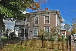 Governor Joseph Johnson House |
March 19, 1987 (#87000490) |
424 Oakdale Ave. 39°17′07″N 80°15′32″W |
Bridgeport | |
| 9 | Lost Creek Baltimore and Ohio Railroad Depot |  Lost Creek Baltimore and Ohio Railroad Depot |
July 6, 2005 (#05000660) |
Main St., Lost Creek Rd., and County Route 48 39°09′37″N 80°21′06″W |
Lost Creek | |
| 10 | Quality Hill Historic District | 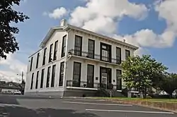 Quality Hill Historic District |
August 22, 1985 (#85001815) |
East Main St. 39°16′43″N 80°19′55″W |
Clarksburg | |
| 11 | Quiet Dell School | 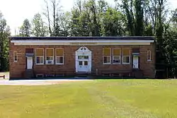 Quiet Dell School |
March 12, 2001 (#01000265) |
Off WV 20 on County Route 20/79 39°13′26″N 80°18′00″W |
Mount Clare | |
| 12 | Salem College Administration Building | 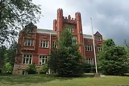 Salem College Administration Building |
March 30, 1989 (#89000184) |
223 W. Main St. 39°17′01″N 80°34′02″W |
Salem | |
| 13 | Salem Historic District |  Salem Historic District |
December 2, 1980 (#80004022) |
WV 23 39°16′58″N 80°33′32″W |
Salem | |
| 14 | Levi Shinn House | 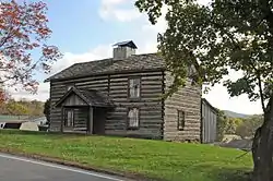 Levi Shinn House |
July 16, 1973 (#73001907) |
Clarksburg Rd. (U.S. Route 19) 39°23′13″N 80°18′40″W |
Shinnston | |
| 15 | Shinnston Historic District | 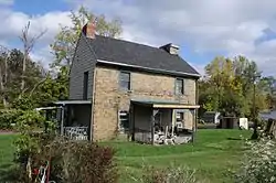 Shinnston Historic District |
April 1, 1998 (#98000288) |
Roughly bounded by Charles, East, and Clement Sts., and West Fork River 39°23′45″N 80°18′03″W |
Shinnston | |
| 16 | Simpson Creek Covered Bridge | June 4, 1981 (#81000600) |
County Route 24/2 at junction of County Route 24 39°18′31″N 80°16′47″W |
Bridgeport | ||
| 17 | Watters Smith Farm on Duck Creek | 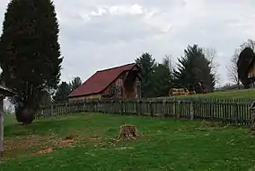 Watters Smith Farm on Duck Creek |
May 16, 1974 (#74002003) |
County Route 25/6 39°10′12″N 80°24′38″W |
Lost Creek | |
| 18 | Stealey-Goff-Vance House | 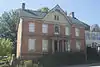 Stealey-Goff-Vance House |
September 25, 1979 (#79002580) |
123 W. Main St. 39°16′42″N 80°20′09″W |
Clarksburg | |
| 19 | Templemoor | 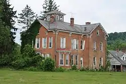 Templemoor |
April 15, 1982 (#82004318) |
WV 20 39°08′41″N 80°14′27″W |
Clarksburg | |
| 20 | Trinity Memorial Methodist Episcopal Church | 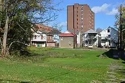 Trinity Memorial Methodist Episcopal Church |
April 26, 1984 (#84003584) |
420 Ben St. 39°16′37″N 80°20′11″W |
Clarksburg | Demolished[5] |
| 21 | Waldomore |  Waldomore |
October 4, 1978 (#78002797) |
W. Pike and N. 4th Sts. 39°16′54″N 80°20′25″W |
Clarksburg |
Former listing
| [3] | Name on the Register | Image | Date listed | Date removed | Location | City or town | Summary |
|---|---|---|---|---|---|---|---|
| 1 | Nathan Goff Jr. House | December 12, 1976 (#76001936) | February 18, 1994 | 463 W. Main St. 39°16′48″N 80°20′32″W |
Clarksburg | Demolished in 1993. Included in Clarksburg Downtown Historic District. |
See also
| Wikimedia Commons has media related to National Register of Historic Places in Harrison County, West Virginia. |
References
- The latitude and longitude information provided in this table was derived originally from the National Register Information System, which has been found to be fairly accurate for about 99% of listings. Some locations in this table may have been corrected to current GPS standards.
- "National Register of Historic Places: Weekly List Actions". National Park Service, United States Department of the Interior. Retrieved on January 29, 2021.
- Numbers represent an alphabetical ordering by significant words. Various colorings, defined here, differentiate National Historic Landmarks and historic districts from other NRHP buildings, structures, sites or objects.
- The eight-digit number below each date is the number assigned to each location in the National Register Information System database, which can be viewed by clicking the number.
- Harrison County, West Virginia Division of Culture and History, 2010. Accessed 2010-09-14.
| Topics | ||
|---|---|---|
| Lists by county |
| |
| Other lists | ||
| ||
Municipalities and communities of Harrison County, West Virginia, United States | ||
|---|---|---|
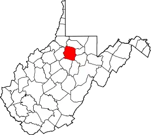
| Cities | Map of West Virginia highlighting Harrison County | |
| Towns | ||
| CDPs | ||
| Unincorporated communities |
| |
| ||