National Register of Historic Places listings in Randolph County, West Virginia
This is a list of the National Register of Historic Places listings in Randolph County, West Virginia.
This is intended to be a complete list of the properties and districts on the National Register of Historic Places in Randolph County, West Virginia, United States. The locations of National Register properties and districts for which the latitude and longitude coordinates are included below, may be seen in an online map.[1]
There are 35 properties and districts listed on the National Register in the county, 1 of which is a National Historic Landmark.
- This National Park Service list is complete through NPS recent listings posted February 5, 2021.[2]
Barbour - Berkeley - Boone - Braxton - Brooke - Cabell - Calhoun - Clay - Doddridge - Fayette - Gilmer - Grant - Greenbrier - Hampshire - Hancock - Hardy - Harrison - Jackson - Jefferson - Kanawha - Lewis - Lincoln - Logan - Marion - Marshall - Mason - McDowell - Mercer - Mineral - Mingo - Monongalia - Monroe - Morgan - Nicholas - Ohio - Pendleton - Pleasants - Pocahontas - Preston - Putnam - Raleigh - Randolph - Ritchie - Roane - Summers - Taylor - Tucker - Tyler - Upshur - Wayne - Webster - Wetzel - Wirt - Wood - Wyoming |
Current listings
| [3] | Name on the Register[4] | Image | Date listed[5] | Location | City or town | Description |
|---|---|---|---|---|---|---|
| 1 | Albert and Liberal Arts Halls | 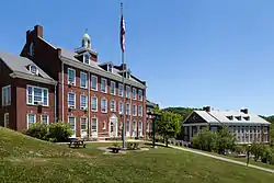 Albert and Liberal Arts Halls |
August 29, 1979 (#79002599) |
Davis and Elkins College campus 38°55′49″N 79°50′46″W |
Elkins | |
| 2 | Baldwin-Chandlee Supply Company-Valley Supply Company | .jpg.webp) Baldwin-Chandlee Supply Company-Valley Supply Company |
December 4, 1998 (#98001478) |
Junction of 10th and Railroad Sts. 38°55′18″N 79°51′14″W |
Elkins | |
| 3 | Beverly Historic District |  Beverly Historic District |
January 11, 1980 (#80004040) |
US 219/US 250/WV 55/WV 92; Roughly bounded by Dodson Run, Files Cr., Tygart Valley R. & Lewis St. 38°50′29″N 79°52′30″W |
Beverly | Second set of addresses represents a boundary increase 2014-12-16 |
| 4 | Blackman-Bosworth Store |  Blackman-Bosworth Store |
April 14, 1975 (#75001897) |
Main and Court Sts. 38°50′27″N 79°52′32″W |
Beverly | |
| 5 | Butcher Hill Historic District | November 9, 1989 (#89001784) |
East of Beverly 38°50′33″N 79°51′02″W |
Beverly | ||
| 6 | Cheat Summit Fort | 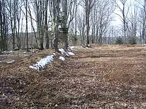 Cheat Summit Fort |
September 28, 1990 (#90001445) |
County Route 250/4, west of FR 233 at White Top[6][7] 38°37′28″N 79°52′36″W |
Huttonsville | |
| 7 | Davis and Elkins Historic District | 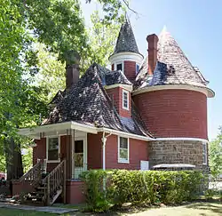 Davis and Elkins Historic District |
June 19, 1996 (#96001129) |
Davis and Elkins College campus 38°55′48″N 79°50′50″W |
Elkins | |
| 8 | Davis Memorial Presbyterian Church | 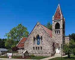 Davis Memorial Presbyterian Church |
April 20, 1984 (#84003664) |
450 Randolph Ave. 38°55′39″N 79°50′53″W |
Elkins | |
| 9 | Day-Vandevander Mill | 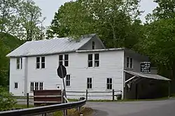 Day-Vandevander Mill |
July 21, 1987 (#87001173) |
WV 32 38°55′57″N 79°31′16″W |
Harman | |
| 10 | Downtown Elkins Historic District | 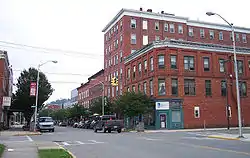 Downtown Elkins Historic District |
November 22, 1995 (#95001324) |
Roughly bounded by Railroad Ave., 5th St., Randolph Ave., Henry Ave. and 1st St. 38°55′28″N 79°50′57″W |
Elkins | |
| 11 | Elkins Milling Company |  Elkins Milling Company |
February 2, 2005 (#04001595) |
2½ Railroad Ave. 38°55′23″N 79°51′05″W |
Elkins | |
| 12 | Senator Stephen Benton Elkins House | 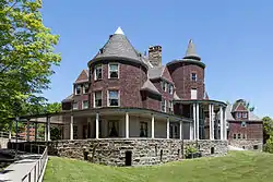 Senator Stephen Benton Elkins House |
September 2, 1982 (#82004329) |
Davis and Elkins College campus 38°55′51″N 79°50′50″W |
Elkins | |
| 13 | First Ward School |  First Ward School |
December 30, 2009 (#09001193) |
S. Davis Ave. and 13th St. 38°55′03″N 79°51′06″W |
Elkins | |
| 14 | Fort Marrow | July 30, 2010 (#10000511) |
North corner U.S. Route 219 and County Route 219/16 38°38′00″N 80°01′21″W |
Huttonsville | Also known as Camp Elkwater[8] | |
| 15 | Glady Presbyterian Church and Manse | 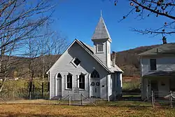 Glady Presbyterian Church and Manse |
November 30, 2005 (#05001347) |
Junction of Randolph Ave. and 1st St. 38°47′52″N 79°43′10″W |
Glady | |
| 16 | Graceland | .jpg.webp) Graceland |
September 17, 1970 (#70000666) |
Davis and Elkins College campus 38°55′51″N 79°50′57″W |
Elkins | |
| 17 | Helvetia | 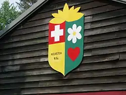 Helvetia |
November 29, 1978 (#78002810) |
Junction of County Route 45 and County Route 46 38°42′19″N 80°12′14″W |
Helvetia | |
| 18 | E. E. Hutton House | June 11, 1975 (#75001898) |
Junction of U.S. Routes 219 and 250 and Union St. 38°42′56″N 79°58′45″W |
Huttonsville | ||
| 19 | Dr. John C. Irons House |  Dr. John C. Irons House |
December 15, 1998 (#98001479) |
116 2nd St. 38°55′25″N 79°50′58″W |
Elkins | |
| 20 | Gov. H. Guy Kump House |  Gov. H. Guy Kump House |
August 18, 1983 (#04000319) |
Randolph Ave. and 11th St.[9][10][11] 38°55′04″N 79°50′33″W |
Elkins | |
| 21 | Middle Mountain Cabins | 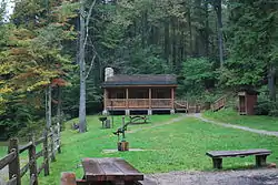 Middle Mountain Cabins |
September 27, 1990 (#90001447) |
Eastern side of Middle Mountain Rd. at Camp Five Run, Monongahela National Forest 38°41′18″N 79°44′03″W |
Wymer | |
| 22 | New Deal Resources in Kumbrabow State Forest Historic District | August 7, 2019 (#100002855) |
219/16, Kumbrabow Rd. 38°37′52″N 80°05′04″W |
Huttonsville | ||
| 23 | Fred A. Perley House | September 14, 1988 (#88001453) |
Address Restricted |
Jenningston | ||
| 24 | Pinecrest |  Pinecrest |
December 11, 1979 (#79002600) |
Kerens Hill 38°55′53″N 79°51′11″W |
Elkins | |
| 25 | Randolph County Courthouse and Jail | 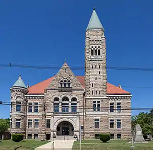 Randolph County Courthouse and Jail |
November 28, 1980 (#80004041) |
Randolph Ave. and High St. 38°55′22″N 79°50′35″W |
Elkins | |
| 26 | Rich Mountain Battlefield | 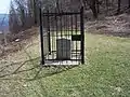 Rich Mountain Battlefield |
July 17, 1992 (#92000899) |
6 miles west of Beverly on Rich Mountain Rd. (County Route 37/8) 38°52′01″N 79°56′41″W |
Beverly | |
| 27 | Riverside School |  Riverside School |
December 30, 2009 (#09001194) |
Block No. 1, River St. 38°55′20″N 79°50′53″W |
Elkins | |
| 28 | Scott Hill | .jpg.webp) Scott Hill |
December 22, 2008 (#08001240) |
2000 Livingston Ave. 38°54′48″N 79°51′39″W |
Elkins | |
| 29 | See-Ward House | August 25, 1988 (#88000671) |
U.S. Routes 219/250 38°43′31″N 79°58′22″W |
Mill Creek | ||
| 30 | Taylor-Condry House |  Taylor-Condry House |
August 18, 1983 (#83003252) |
1700 Taylor Ave. 38°54′48″N 79°51′28″W |
Elkins | |
| 31 | Tygart Valley Homesteads Historic District | July 22, 2004 (#04000304) |
Roughly bounded by U.S. Routes 219/250 and County Roads 21 and 38 38°46′37″N 79°54′25″W |
Dailey | ||
| 32 | Tygarts Valley Church | 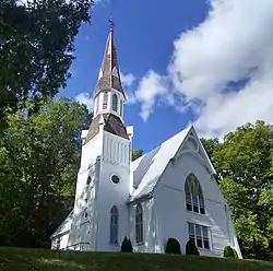 Tygarts Valley Church |
April 15, 1986 (#86000797) |
U.S. Route 219 38°43′02″N 79°58′41″W |
Huttonsville | |
| 33 | Warfield-Dye Residence |  Warfield-Dye Residence |
November 13, 1997 (#97001412) |
318 Buffalo St. 38°55′42″N 79°50′42″W |
Elkins | |
| 34 | Wees Historic District |  Wees Historic District |
March 24, 2006 (#06000164) |
Generally bounded by Randolph and S. Randolph Aves., Sycamore St., Diamond St. and Boundary and Terrace Aves. 38°55′39″N 79°50′33″W |
Elkins | |
| 35 | West Virginia Children's Home |  West Virginia Children's Home |
November 4, 1994 (#94001287) |
230 Heavener Ave. 38°55′58″N 79°51′29″W |
Elkins |
Former listings
| [3] | Name on the Register | Image | Date listed | Date removed | Location | City or town | Summary |
|---|---|---|---|---|---|---|---|
| 1 | Elkins Round Barn | July 9, 1985 (#85001547) | December 17, 1990 | US 219 |
Elkins |
See also
| Wikimedia Commons has media related to National Register of Historic Places in Randolph County, West Virginia. |
References
- The latitude and longitude information provided in this table was derived originally from the National Register Information System, which has been found to be fairly accurate for about 99% of listings. Some locations in this table may have been corrected to current GPS standards.
- "National Register of Historic Places: Weekly List Actions". National Park Service, United States Department of the Interior. Retrieved on February 5, 2021.
- Numbers represent an alphabetical ordering by significant words. Various colorings, defined here, differentiate National Historic Landmarks and historic districts from other NRHP buildings, structures, sites or objects.
- "National Register Information System". National Register of Historic Places. National Park Service. April 24, 2008.
- The eight-digit number below each date is the number assigned to each location in the National Register Information System database, which can be viewed by clicking the number.
- The NRIS lists Cheat Summit Fort as "Address Restricted"; location is derived from Monongahela National Forest (Map). 1:126,720. Monongahela National Forest. 2007. ISBN 978-1-59351-857-8.
- "Cheat Summit". Monongahela National Forest. Archived from the original on 2009-01-18. Retrieved 2009-01-18.
- "Forgotten Fortification Saved at Elkwater". Elkins, West Virginia: The Inter-Mountain. May 16, 2009. Archived from the original on May 10, 2008. Retrieved August 8, 2010.
- The NRIS lists the house as "Address Restricted"; location is derived from Gaynor, Anthony (2008-08-16). "Is Elkins Nearing Plan for Kump House?". The Inter-Mountain. Archived from the original on 2011-07-16. Retrieved 2009-01-18.
- Gaynor, Anthony (2008-04-23). "Kump House Willed To the City of Elkins". The Inter-Mountain. Archived from the original on 2009-01-18. Retrieved 2009-01-18.
- "Google Map for 38° 55' 4" N, 79° 50' 33" W". Google. Retrieved 2009-01-18.
| Topics | ||
|---|---|---|
| Lists by county |
| |
| Other lists | ||
| ||
Municipalities and communities of Randolph County, West Virginia, United States | ||
|---|---|---|
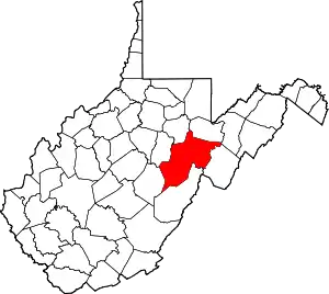
| City | Map of West Virginia highlighting Randolph County | |
| Towns | ||
| CDPs | ||
| Unincorporated communities |
| |
| Ghost towns | ||
| Footnotes | ‡This populated place also has portions in an adjacent county or counties | |
| ||