National Register of Historic Places listings in Fayette County, West Virginia
This is a list of the National Register of Historic Places listings in Fayette County, West Virginia.
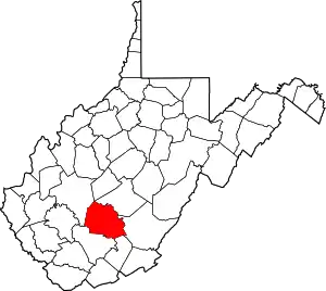
This is intended to be a complete list of the properties and districts on the National Register of Historic Places in Fayette County, West Virginia, United States. The locations of National Register properties and districts for which the latitude and longitude coordinates are included below, may be seen in an online map.[1]
There are 28 properties and districts listed on the National Register in the county.
- This National Park Service list is complete through NPS recent listings posted January 29, 2021.[2]
Barbour - Berkeley - Boone - Braxton - Brooke - Cabell - Calhoun - Clay - Doddridge - Fayette - Gilmer - Grant - Greenbrier - Hampshire - Hancock - Hardy - Harrison - Jackson - Jefferson - Kanawha - Lewis - Lincoln - Logan - Marion - Marshall - Mason - McDowell - Mercer - Mineral - Mingo - Monongalia - Monroe - Morgan - Nicholas - Ohio - Pendleton - Pleasants - Pocahontas - Preston - Putnam - Raleigh - Randolph - Ritchie - Roane - Summers - Taylor - Tucker - Tyler - Upshur - Wayne - Webster - Wetzel - Wirt - Wood - Wyoming |
Current listings
| [3] | Name on the Register | Image | Date listed[4] | Location | City or town | Description |
|---|---|---|---|---|---|---|
| 1 | Altamont Hotel | 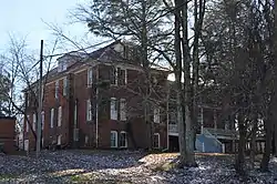 Altamont Hotel |
August 29, 1979 (#79002574) |
110 Fayette Ave. 38°03′09″N 81°06′07″W |
Fayetteville | |
| 2 | Bank of Glen Jean | 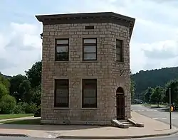 Bank of Glen Jean |
February 10, 1983 (#83003236) |
Main St. 37°55′42″N 81°09′19″W |
Glen Jean | |
| 3 | Camp Washington-Carver Complex | 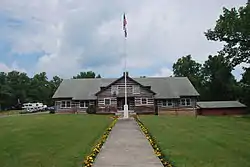 Camp Washington-Carver Complex |
June 20, 1980 (#80004017) |
County Route 11/3 38°00′36″N 80°58′14″W |
Clifftop | |
| 4 | Contentment | 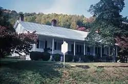 Contentment |
December 30, 1974 (#74001996) |
Along U.S. Route 60 38°08′06″N 81°06′11″W |
Ansted | |
| 5 | Fayette County Courthouse | 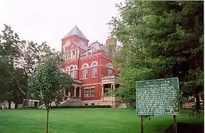 Fayette County Courthouse |
September 6, 1978 (#78002793) |
Court St. between Wiseman and Maple Aves. 38°03′13″N 81°06′13″W |
Fayetteville | |
| 6 | Fayetteville Esso Station |  Fayetteville Esso Station |
December 4, 2018 (#100003250) |
145 S Court St. 38°03′07″N 81°06′08″W |
Fayetteville | |
| 7 | Fayetteville Historic District | 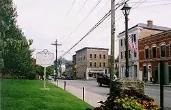 Fayetteville Historic District |
December 20, 1990 (#90001845) |
Roughly bounded by WV 16 and Maple and Fayette Aves. 38°03′05″N 81°06′25″W |
Fayetteville | |
| 8 | Gauley Bridge Railroad Station |  Gauley Bridge Railroad Station |
May 15, 1980 (#80004018) |
Off WV 16/WV 39 38°09′53″N 81°11′46″W |
Gauley Bridge | |
| 9 | Glen Ferris Inn | 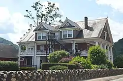 Glen Ferris Inn |
April 25, 1991 (#91000449) |
U.S. Route 60 overlooking Kanawha Falls 38°09′01″N 81°12′53″W |
Glen Ferris | |
| 10 | Halfway House | 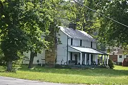 Halfway House |
December 18, 1978 (#78002792) |
Off old U.S. Route 60 38°08′05″N 81°05′39″W |
Ansted | |
| 11 | E. B. Hawkins House | 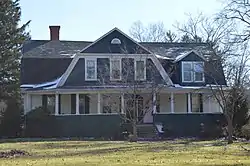 E. B. Hawkins House |
January 18, 1990 (#89002319) |
120 Fayette Ave. 38°03′12″N 81°06′02″W |
Fayetteville | |
| 12 | Dr. John Hughart House | March 26, 2001 (#01000262) |
Off WV 41 37°58′15″N 80°56′07″W |
Landisburg | ||
| 13 | Kay Moor | 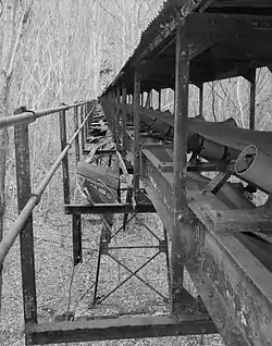 Kay Moor |
November 8, 1990 (#90001641) |
Along the New River south of U.S. Route 19 38°02′52″N 81°03′53″W |
Fayetteville | |
| 14 | Main Building | 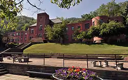 Main Building |
June 25, 1980 (#80004019) |
West Virginia University Institute of Technology campus 38°10′45″N 81°19′31″W |
Montgomery | |
| 15 | Mount Hope Historic District |  Mount Hope Historic District |
August 3, 2007 (#07000785) |
Portions of Main, Tennessee, Montana, and Virginia Sts., Fayette and Mountain Aves., Stadium Dr., N. Pax Ave., and N. Maryland 37°53′33″N 81°10′04″W |
Mount Hope | |
| 16 | New Deal Resources in Babcock State Park Historic District | March 5, 2020 (#100003518) |
486 Babcock Rd. 37°59′43″N 80°57′14″W |
Clifftop | ||
| 17 | New Deal Resources in Hawk's Nest State Park Historic District | .jpg.webp) New Deal Resources in Hawk's Nest State Park Historic District |
February 4, 2011 (#10001225) |
49 Hawks Nest State Park Rd. 38°07′23″N 81°07′13″W |
Ansted | |
| 18 | New River Company General Office Building | 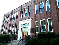 New River Company General Office Building |
April 21, 2004 (#04000357) |
411 Main St. 37°53′47″N 81°09′56″W |
Mt. Hope | |
| 19 | New River Gorge Bridge | New River Gorge Bridge |
August 14, 2013 (#13000603) |
US 19 over New River 38°04′06″N 81°05′00″W |
Fayetteville | |
| 20 | Nuttallburg Coal Mining Complex and Town Historic District |  Nuttallburg Coal Mining Complex and Town Historic District |
August 22, 2007 (#07000846) |
County Route 85/2 38°03′00″N 81°02′25″W |
Nuttallburg | |
| 21 | Oak Hill High School | September 4, 2020 (#100004283) |
140 School St. 37°58′29″N 81°08′56″W |
Oak Hill | ||
| 22 | Oak Hill Railroad Depot | 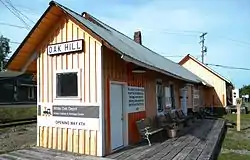 Oak Hill Railroad Depot |
March 17, 1995 (#95000255) |
Junction of Virginia Ave. and Central Ave. 37°58′38″N 81°08′58″W |
Oak Hill | |
| 23 | Page-Vawter House | 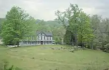 Page-Vawter House |
August 21, 1985 (#85001813) |
Route Box 20 38°08′13″N 81°06′06″W |
Ansted | |
| 24 | Prince Brothers General Store-Berry Store | 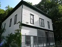 Prince Brothers General Store-Berry Store |
April 17, 1986 (#86000810) |
WV 41 37°51′22″N 81°03′49″W |
Prince | |
| 25 | Soldiers and Sailors Memorial Building | 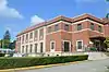 Soldiers and Sailors Memorial Building |
May 31, 2016 (#16000312) |
200 W. Maple Ave. 38°03′07″N 81°06′19″W |
Fayetteville | |
| 26 | Thurmond Historic District | 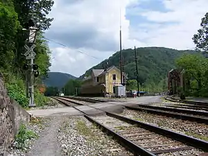 Thurmond Historic District |
January 27, 1984 (#84003520) |
County Route 25/2 at New River 37°57′29″N 81°04′40″W |
Thurmond | |
| 27 | Tyree Stone Tavern | June 20, 1975 (#75001884) |
East of Clifftop off U.S. Route 19 on County Route 10 38°00′42″N 80°54′18″W |
Clifftop | ||
| 28 | Whipple Company Store | 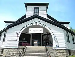 Whipple Company Store |
April 26, 1991 (#91000448) |
Junction of WV 612 and County Route 21/20 37°57′31″N 81°09′57″W |
Scarbro |
See also
| Wikimedia Commons has media related to National Register of Historic Places in Fayette County, West Virginia. |
References
- The latitude and longitude information provided in this table was derived originally from the National Register Information System, which has been found to be fairly accurate for about 99% of listings. Some locations in this table may have been corrected to current GPS standards.
- "National Register of Historic Places: Weekly List Actions". National Park Service, United States Department of the Interior. Retrieved on January 29, 2021.
- Numbers represent an alphabetical ordering by significant words. Various colorings, defined here, differentiate National Historic Landmarks and historic districts from other NRHP buildings, structures, sites or objects.
- The eight-digit number below each date is the number assigned to each location in the National Register Information System database, which can be viewed by clicking the number.
| Topics | ||
|---|---|---|
| Lists by county |
| |
| Other lists | ||
| ||