National Register of Historic Places listings in Bryan County, Georgia
This is a list of properties and districts in Bryan County, Georgia that are listed on the National Register of Historic Places (NRHP).
- This National Park Service list is complete through NPS recent listings posted February 5, 2021.[1]

Current listings
| [2] | Name on the Register | Image | Date listed[3] | Location | City or town | Description |
|---|---|---|---|---|---|---|
| 1 | Bryan County Courthouse | Bryan County Courthouse |
June 14, 1995 (#95000713) |
College St. 32°08′00″N 81°37′17″W |
Pembroke | |
| 2 | Bryan Neck Presbyterian Church | 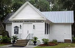 Bryan Neck Presbyterian Church |
March 15, 2000 (#00000193) |
Belfast Keller Rd. 31°50′30″N 81°15′40″W |
Keller | |
| 3 | Fort McAllister | 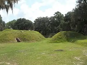 Fort McAllister |
May 13, 1970 (#70000197) |
10 mi. E of Richmond Hill via GA 67 31°53′30″N 81°11′42″W |
Richmond Hill | Now a Georgia state historic site website |
| 4 | Glen Echo | 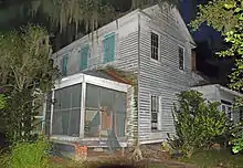 Glen Echo |
January 9, 1978 (#78000965) |
2 miles (3 km) east of Ellabelle on GA 204 32°08′07″N 81°27′53″W |
Ellabelle | |
| 5 | Kilkenny | 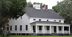 Kilkenny |
February 14, 1979 (#79000700) |
E of Richmond Hill on Kilkenny Rd. 31°47′24″N 81°12′12″W |
Richmond Hill | |
| 6 | Old Fort Argyle Site | 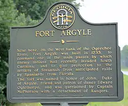 Old Fort Argyle Site |
March 31, 1975 (#75000574) |
Address Restricted (on the west bank of the Ogeechee River in Fort Stewart) |
Savannah | |
| 7 | Pembroke Historic District | Pembroke Historic District |
December 8, 2004 (#04001318) |
Centered on US 280 and Main St. 32°08′09″N 81°37′24″W |
Pembroke | |
| 8 | Richmond Hill Plantation | .jpg.webp) Richmond Hill Plantation |
January 30, 1978 (#78000966) |
E of Richmond Hill on Ford Neck Rd. 31°55′33″N 81°16′35″W |
Richmond Hill | On private property (gated) |
| 9 | Seven Mile Bend |  Seven Mile Bend |
April 11, 1972 (#72000373) |
Address Restricted |
Richmond Hill | Facebook page |
| 10 | Strathy Hall |  Strathy Hall |
January 21, 1979 (#79000701) |
SE of Richmond Hill 31°54′17″N 81°15′05″W |
Richmond Hill |
References
- "National Register of Historic Places: Weekly List Actions". National Park Service, United States Department of the Interior. Retrieved on February 5, 2021.
- Numbers represent an alphabetical ordering by significant words. Various colorings, defined here, differentiate National Historic Landmarks and historic districts from other NRHP buildings, structures, sites or objects.
- The eight-digit number below each date is the number assigned to each location in the National Register Information System database, which can be viewed by clicking the number.
| Wikimedia Commons has media related to National Register of Historic Places in Bryan County, Georgia. |
This article is issued from Wikipedia. The text is licensed under Creative Commons - Attribution - Sharealike. Additional terms may apply for the media files.