National Register of Historic Places listings in Mitchell County, Georgia
This is a list of properties and districts in Mitchell County, Georgia that are listed on the National Register of Historic Places (NRHP).
- This National Park Service list is complete through NPS recent listings posted January 29, 2021.[1]

Current listings
| [2] | Name on the Register | Image | Date listed[3] | Location | City or town | Description |
|---|---|---|---|---|---|---|
| 1 | Bacon Family Homestead | November 25, 1983 (#83003591) |
W. Durham St. and Albany Bainbridge Stage Rd. 31°22′43″N 84°10′24″W |
Baconton | ||
| 2 | Baconton Commercial Historic District | 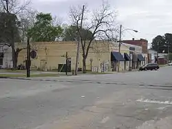 Baconton Commercial Historic District |
December 1, 1983 (#83003603) |
E. Walton and E. Durham Sts., N. Railroad and S. Railroad Aves., and GA 3 31°22′30″N 84°09′42″W |
Baconton | |
| 3 | Camilla Commercial Historic District |  Camilla Commercial Historic District |
April 18, 1985 (#85000862) |
Roughly bounded by Broad, S. Scott and N. Scott Sts. 31°13′52″N 84°12′37″W |
Camilla | |
| 4 | George W. Jackson House | 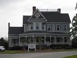 George W. Jackson House |
December 1, 1983 (#83003595) |
333 E. Walton St. 31°22′30″N 84°09′11″E |
Baconton | 1898-built Late Victorian house now serving as Baconton's city hall |
| 5 | James Price McRee House | 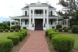 James Price McRee House |
December 11, 1979 (#79000734) |
181 E. Broad St. 31°13′50″N 84°12′07″W |
Camilla | 1907 Classical Revival-style house currently housing the Southern Georgia Regional Commission |
| 6 | Mount Enon Church and Cemetery | December 22, 1983 (#83003596) |
Old Stage Coach Rd. 31°23′57″N 84°06′50″W |
Baconton | ||
| 7 | Pelham Commercial Historic District |  Pelham Commercial Historic District |
March 24, 1983 (#83000238) |
Roughly bounded by RR tracks, Church, Blythe, Jackson Sts. & Hand Ave. 31°07′31″N 84°09′12″W |
Pelham | |
| 8 | South Railroad Historic District | 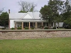 South Railroad Historic District |
December 1, 1983 (#83003597) |
S. Railroad Ave., GA 3, and Seaboard Coast Line RR tracks 31°22′16″N 84°09′51″W |
Baconton | |
| 9 | Walton Street-Church Street Historic District | 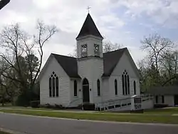 Walton Street-Church Street Historic District |
December 1, 1983 (#83003602) |
Walton and Church Sts. 31°22′29″N 84°09′24″W |
Baconton | |
| 10 | Georgia Williams Nursing Home | April 8, 2011 (#11000180) |
176 Dyer St. 31°14′12″N 84°12′28″W |
Camilla | Georgia Traveler website |
References
- "National Register of Historic Places: Weekly List Actions". National Park Service, United States Department of the Interior. Retrieved on January 29, 2021.
- Numbers represent an alphabetical ordering by significant words. Various colorings, defined here, differentiate National Historic Landmarks and historic districts from other NRHP buildings, structures, sites or objects.
- The eight-digit number below each date is the number assigned to each location in the National Register Information System database, which can be viewed by clicking the number.
| Wikimedia Commons has media related to National Register of Historic Places in Mitchell County, Georgia. |
This article is issued from Wikipedia. The text is licensed under Creative Commons - Attribution - Sharealike. Additional terms may apply for the media files.