National Register of Historic Places listings in Franklin County, Georgia
This is a list of properties and districts in Franklin County, Georgia that are listed on the National Register of Historic Places (NRHP).
- This National Park Service list is complete through NPS recent listings posted January 29, 2021.[1]

Current listings
| [2] | Name on the Register | Image | Date listed[3] | Location | City or town | Description |
|---|---|---|---|---|---|---|
| 1 | Adams House | September 1, 1983 (#83000199) |
Hartwell Rd. 34°25′52″N 83°05′37″W |
Lavonia | ||
| 2 | William Ariail House | 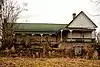 William Ariail House |
November 7, 1996 (#96001297) |
GA 51, approximately .25 mi. SE of the Banks-Franklin County line 34°21′54″N 83°23′05″W |
Carnesville | |
| 3 | Ayers-Little Boarding House | Ayers-Little Boarding House |
April 16, 2008 (#08000292) |
121 Athens St. 34°22′11″N 83°14′01″W |
Carnesville | Frame one- and one-half-story house located at the southeastern corner of the courthouse square |
| 4 | Baty School | November 7, 1996 (#96001302) |
GA 198, approximately .25 mi. N of jct. with GA 59 34°21′40″N 83°16′53″W |
Carnesville | ||
| 5 | Beasley House | September 1, 1983 (#83000200) |
75 Grogan St. 34°26′11″N 83°06′08″W |
Lavonia | ||
| 6 | Bellamy Historic District | November 7, 1996 (#96001304) |
GA 51, approximately 2.75 mi. NW of jct. with I-85 34°22′17″N 83°21′55″W |
Carnesville | ||
| 7 | John R. and Mary Bond Bond House | November 7, 1996 (#96001301) |
GA 59, approximately .5 mi. NE of jct. with GA 51 34°20′50″N 83°18′29″W |
Carnesville | ||
| 8 | Bond-Baker-Carter House | September 11, 1986 (#86002403) |
Address Restricted |
Royston | ||
| 9 | Brown-Kennedy House | November 7, 1996 (#96001303) |
GA 59, approximately 1 mi. NE of jct. with GA 51 34°21′03″N 83°18′02″W |
Carnesville | ||
| 10 | Burton House | September 1, 1983 (#83000201) |
Augusta Rd. 34°25′57″N 83°06′27″W |
Lavonia | ||
| 11 | Cannon-McDaniel House | September 1, 1983 (#83000202) |
126 West Ave. 34°26′01″N 83°07′00″W |
Lavonia | ||
| 12 | Canon Commercial Historic District | August 1, 1985 (#85001681) |
Depot St. between Bond Ave. & Broad St. 34°20′46″N 83°06′36″W |
Canon | ||
| 13 | Cason House | September 1, 1983 (#83000203) |
60 Grogan St. 34°26′11″N 83°06′13″W |
Lavonia | ||
| 14 | Cheek House | 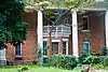 Cheek House |
September 1, 1983 (#83000204) |
38 Hartwell Rd. 34°26′02″N 83°06′05″W |
Lavonia | |
| 15 | Crawford-Shirley House | September 1, 1983 (#83000205) |
100 Augusta Rd. 34°25′41″N 83°06′22″W |
Lavonia | ||
| 16 | Cromer's Mill Covered Bridge | 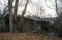 Cromer's Mill Covered Bridge |
August 17, 1976 (#76000619) |
8 mi. S of Carnesville at Nails Creek 34°16′29″N 83°15′57″W |
Carnesville | |
| 17 | Fisher House | September 1, 1983 (#83000206) |
221 Hartwell Rd. 34°25′59″N 83°05′57″W |
Lavonia | ||
| 18 | Franklin County Courthouse | 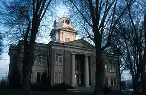 Franklin County Courthouse |
September 18, 1980 (#80001069) |
Courthouse Sq. 34°22′12″N 83°14′05″W |
Carnesville | |
| 19 | Hamilton Historic District |  Hamilton Historic District |
November 7, 1996 (#96001300) |
GA 51, approximately .5 mi. NW of jct. with I-85 34°20′54″N 83°19′49″W |
Carnesville | |
| 20 | Historic Churches of Canon Historic District |  Historic Churches of Canon Historic District |
August 1, 1985 (#85001680) |
Broad St. at Canon Ave. 34°20′41″N 83°06′35″W |
Canon | |
| 21 | Jones Street Residential Historic District | September 1, 1983 (#83000207) |
Jones, Baker, and Old Carnesville Rd. 34°26′16″N 83°06′32″W |
Lavonia | ||
| 22 | Keese House | September 1, 1983 (#83000208) |
4 Burgess St. 34°25′57″N 83°06′34″W |
Lavonia | ||
| 23 | Kidd House | September 1, 1983 (#83000209) |
222 Hartwell Rd. 34°25′56″N 83°06′00″W |
Lavonia | ||
| 24 | Killingsworth Farm | September 1, 1983 (#83000210) |
Hartwell Rd. 34°25′54″N 83°05′27″W |
Lavonia | ||
| 25 | Lavonia-Carnegie Library | 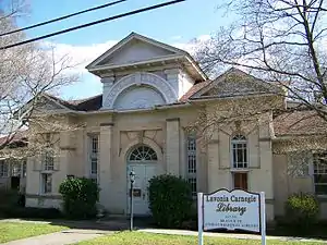 Lavonia-Carnegie Library |
September 1, 1983 (#83000211) |
Hartwell Rd. 34°26′05″N 83°06′14″W |
Lavonia | |
| 26 | Lavonia Commercial Historic District | 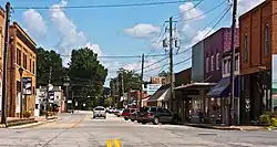 Lavonia Commercial Historic District |
September 1, 1983 (#83000212) |
Jones, Augusta, Vickery, Grogan, Bowman Sts. 34°26′10″N 83°06′24″W |
Lavonia | |
| 27 | Lavonia Cotton Mill | 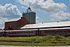 Lavonia Cotton Mill |
September 1, 1983 (#83000213) |
Main St. 34°25′45″N 83°06′08″W |
Lavonia | |
| 28 | Lavonia Roller Mill | 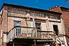 Lavonia Roller Mill |
September 1, 1983 (#83000214) |
E. Main St. 34°26′01″N 83°06′17″W |
Lavonia | |
| 29 | McConnell Historic District | 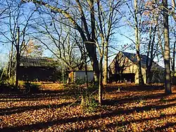 McConnell Historic District |
November 7, 1996 (#96001299) |
GA 51, approximately 2.5 mi. NW of jct. with I-85 34°22′00″N 83°21′13″W |
Carnesville | |
| 30 | McMurray House | September 1, 1983 (#83000215) |
Hartwell Rd. 34°25′59″N 83°06′03″W |
Lavonia | ||
| 31 | Pure Oil Service Station | September 1, 1983 (#83000216) |
56 West Ave. 34°26′07″N 83°06′28″W |
Lavonia | ||
| 32 | Queen House | September 1, 1983 (#83000217) |
Hartwell Rd. 34°25′54″N 83°05′25″W |
Lavonia | ||
| 33 | Royston Commercial Historic District | 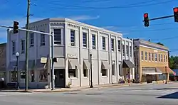 Royston Commercial Historic District |
September 5, 1985 (#85001969) |
Along Church and Railroad Sts. 34°17′12″N 83°06′37″W |
Royston | |
| 34 | Southern Cotton Oil Co. | 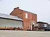 Southern Cotton Oil Co. |
September 1, 1983 (#83000218) |
W. Main St. 34°26′00″N 83°06′20″W |
Lavonia | |
| 35 | Stevenson House and Brickyard | September 1, 1983 (#83000219) |
Hartwell Rd. 34°26′02″N 83°06′08″W |
Lavonia | ||
| 36 | Stovall Homeplace | September 1, 1983 (#83000220) |
114 West Ave. 34°25′48″N 83°07′02″W |
Lavonia | ||
| 37 | Stovall-Purcell House | September 1, 1983 (#83000221) |
110 West Ave. 34°26′00″N 83°06′54″W |
Lavonia | ||
| 38 | Strange-Duncan House | 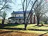 Strange-Duncan House |
November 7, 1996 (#96001298) |
GA 51, approximately .75 mi. E of the Franklin-Banks County line 34°22′16″N 83°22′48″W |
Carnesville | |
| 39 | Vandiver House | September 1, 1983 (#83000222) |
Main St. 34°26′28″N 83°06′36″W |
Lavonia | ||
| 40 | Vickery House | September 1, 1983 (#83000223) |
Grogan St. 34°26′10″N 83°06′15″W |
Lavonia | ||
| 41 | Vickery Street Historic District | September 1, 1983 (#83000224) |
Vickery St. 34°26′28″N 83°06′23″W |
Lavonia | ||
| 42 | Walnut Hill Historic District | 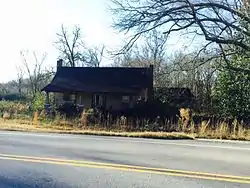 Walnut Hill Historic District |
November 7, 1996 (#96001296) |
GA 51, approximately 1 mi. NW of jct. with I-85 34°21′23″N 83°20′34″W |
Carnesville | |
| 43 | West Avenue-Roberts Street Residential Historic District | September 1, 1983 (#83000225) |
Between Mason and Jones Sts. 34°26′05″N 83°06′36″W |
Lavonia | ||
| 44 | Yow House | 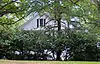 Yow House |
September 1, 1983 (#83000226) |
109 Hartwell Rd. 34°26′01″N 83°06′02″W |
Lavonia |
References
- "National Register of Historic Places: Weekly List Actions". National Park Service, United States Department of the Interior. Retrieved on January 29, 2021.
- Numbers represent an alphabetical ordering by significant words. Various colorings, defined here, differentiate National Historic Landmarks and historic districts from other NRHP buildings, structures, sites or objects.
- The eight-digit number below each date is the number assigned to each location in the National Register Information System database, which can be viewed by clicking the number.
| Wikimedia Commons has media related to National Register of Historic Places in Franklin County, Georgia. |
| Topics | |
|---|---|
| Lists by state |
|
| Lists by insular areas | |
| Lists by associated state | |
| Other areas | |
| Related | |
| |
This article is issued from Wikipedia. The text is licensed under Creative Commons - Attribution - Sharealike. Additional terms may apply for the media files.