National Register of Historic Places listings in Barrow County, Georgia
This is a list of properties and districts in Barrow County, Georgia that are listed on the National Register of Historic Places (NRHP).
- This National Park Service list is complete through NPS recent listings posted January 29, 2021.[1]

Current listings
| [2] | Name on the Register | Image | Date listed[3] | Location | City or town | Description |
|---|---|---|---|---|---|---|
| 1 | Athens-Candler-Church Street Historic District | 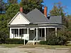 Athens-Candler-Church Street Historic District |
April 17, 1986 (#86000799) |
Roughly Candler St. between Melrose and Woodlawn Sts., Church St., and Athens St. between Horton and Center Sts. 33°59′43″N 83°43′37″W |
Winder | |
| 2 | Auburn Historic District | 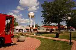 Auburn Historic District |
June 4, 1997 (#97000527) |
Roughly bounded by 3rd Ave., 6th St., 6th Ave., and Main St. 34°00′48″N 83°49′39″W |
Auburn | |
| 3 | Barrow County Courthouse |  Barrow County Courthouse |
September 18, 1980 (#80000970) |
Courthouse Sq. 33°59′32″N 83°43′18″W |
Winder | |
| 4 | Broad Street Commercial Historic District | 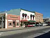 Broad Street Commercial Historic District |
July 26, 1984 (#84000884) |
Broad and Athens Sts. 33°59′33″N 83°43′17″W |
Winder | |
| 5 | Carlyle-Blakey Farm | April 29, 2008 (#08000353) |
568 GA 211 NW. 34°00′40″N 83°45′27″W |
Winder | ||
| 6 | Jackson Street Commercial Historic District | 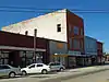 Jackson Street Commercial Historic District |
July 26, 1984 (#84000885) |
Roughly bounded by Jackson, Athens, Candler, and Broad Sts. 33°59′31″N 83°43′11″W |
Winder | |
| 7 | Jackson-Johns House | 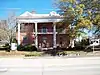 Jackson-Johns House |
April 18, 1985 (#85000847) |
39 Candler St. 33°59′37″N 83°43′16″W |
Winder | |
| 8 | Kilgore Mill Covered Bridge and Mill Site | 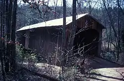 Kilgore Mill Covered Bridge and Mill Site |
April 14, 1975 (#75000572) |
3.5 mi. SW of Bethlehem across Apalachee River/county line 33°54′00″N 83°44′25″W |
Bethlehem | |
| 9 | Manning Gin Farm | 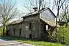 Manning Gin Farm |
May 8, 1991 (#91000541) |
Jct. of Manning Gin and McElhannon Rds. 33°55′36″N 83°42′09″W |
Bethlehem | |
| 10 | North Broad Street Residential Historic District | 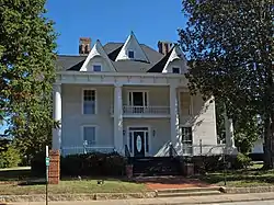 North Broad Street Residential Historic District |
July 26, 1984 (#84000888) |
Roughly bounded by Woodlawn Ave., Center, Broad, and Stephens Sts. 33°59′43″N 83°43′06″W |
Winder | |
| 11 | Omer Christian Church and Cemetery | 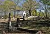 Omer Christian Church and Cemetery |
February 10, 2000 (#00000074) |
Jct. of GA 316 and GA 324 33°57′09″N 83°45′46″W |
Winder | |
| 12 | Rockwell Universalist Church | 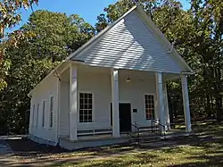 Rockwell Universalist Church |
May 2, 1985 (#85000933) |
GA 53 & Rockwell Church Rd. 34°02′07″N 83°42′49″W |
Winder | |
| 13 | Russell Homeplace Historic District | September 7, 1984 (#84000890) |
US 29 33°58′33″N 83°42′17″W |
Russell | ||
| 14 | Statham Historic District | 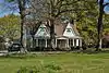 Statham Historic District |
December 17, 1998 (#98001521) |
Roughly bounded by Elizabeth, 8th, and 1st Sts., and CSX RR tracks 33°57′53″N 83°35′42″W |
Statham | |
| 15 | Winder Depot | 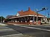 Winder Depot |
May 8, 1979 (#79000696) |
Broad and Porter Sts. 33°59′29″N 83°43′21″W |
Winder |
References
- "National Register of Historic Places: Weekly List Actions". National Park Service, United States Department of the Interior. Retrieved on January 29, 2021.
- Numbers represent an alphabetical ordering by significant words. Various colorings, defined here, differentiate National Historic Landmarks and historic districts from other NRHP buildings, structures, sites or objects.
- The eight-digit number below each date is the number assigned to each location in the National Register Information System database, which can be viewed by clicking the number.
| Wikimedia Commons has media related to National Register of Historic Places in Barrow County, Georgia. |
This article is issued from Wikipedia. The text is licensed under Creative Commons - Attribution - Sharealike. Additional terms may apply for the media files.