National Register of Historic Places listings in Bulloch County, Georgia
This is a list of properties and districts in Bulloch County, Georgia that are listed on the National Register of Historic Places (NRHP).
- This National Park Service list is complete through NPS recent listings posted February 5, 2021.[1]

Current listings
| [2] | Name on the Register | Image | Date listed[3] | Location | City or town | Description |
|---|---|---|---|---|---|---|
| 1 | Sol Akins Farm | March 22, 1990 (#90000487) |
Old Register Rd. off US 301, 1.2 mi. S of Statesboro 32°24′21″N 81°48′11″W |
Statesboro | On private property | |
| 2 | James Alonzo Brannen House | 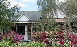 James Alonzo Brannen House |
September 6, 1989 (#89001154) |
112 S. Main St./US 301 32°26′46″N 81°47′00″W |
Statesboro | |
| 3 | Bulloch County Courthouse | 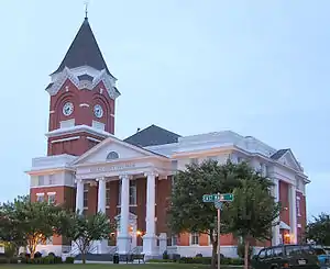 Bulloch County Courthouse |
September 18, 1980 (#80000978) |
Courthouse Sq. 32°26′57″N 81°46′59″W |
Statesboro | |
| 4 | Donehoo-Brannen House | 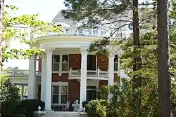 Donehoo-Brannen House |
July 7, 1995 (#95000826) |
332 Savannah Ave. 32°26′36″N 81°46′23″W |
Statesboro | Also part of the Savannah Avenue Historic District |
| 5 | East Main Street Commercial Historic District | 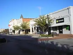 East Main Street Commercial Historic District |
September 6, 1989 (#89001155) |
Roughly E. Main St./US 301 between Siebald and Oak Sts. 32°26′56″N 81°46′56″W |
Statesboro | |
| 6 | East Vine Street Warehouse and Depot District | 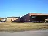 East Vine Street Warehouse and Depot District |
September 6, 1989 (#89001156) |
Roughly bounded by E. Vine St., Central of Georgia Railroad tracks, and Cherry St. 32°26′51″N 81°46′52″W |
Statesboro | Partially demolished in 2016 |
| 7 | Dr. Madison Monroe Holland House | 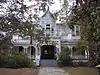 Dr. Madison Monroe Holland House |
September 6, 1989 (#89001157) |
27 S. Main St./US 301 32°26′52″N 81°47′02″W |
Statesboro | |
| 8 | Jaeckel Hotel | 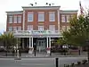 Jaeckel Hotel |
June 17, 1982 (#82002389) |
50 E. Main St. 32°26′55″N 81°46′54″W |
Statesboro | Currently used as City Hall |
| 9 | John A. McDougald House | 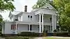 John A. McDougald House |
June 21, 1982 (#82002390) |
121 S. Main St. 32°26′44″N 81°47′03″W |
Statesboro | Currently the Beaver House Restaurant |
| 10 | Dr. John C. Nevil House | Dr. John C. Nevil House |
August 10, 1989 (#89001105) |
US 301 S of Register 32°17′08″N 81°52′37″W |
Register | |
| 11 | North College Street Residential Historic District | .jpg.webp) North College Street Residential Historic District |
September 6, 1989 (#89001158) |
Roughly N. College St. from Northside Dr. to Elm St. 32°27′12″N 81°47′06″W |
Statesboro | |
| 12 | North Main Street Commercial Historic District | .jpg.webp) North Main Street Commercial Historic District |
September 6, 1989 (#89001159) |
Roughly N. Main St. between Courtland and W. Main Sts. 32°26′57″N 81°47′00″W |
Statesboro | |
| 13 | William W. Olliff Farm | 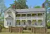 William W. Olliff Farm |
December 4, 1987 (#87002113) |
New Hope Rd. 32°17′25″N 81°56′33″W |
Register | |
| 14 | William G. Raines House | .jpg.webp) William G. Raines House |
August 31, 1987 (#87000942) |
106 S. Main St. 32°26′47″N 81°47′00″W |
Statesboro | Currently known as "The Historic Statesboro Inn" |
| 15 | Savannah Avenue Historic District | 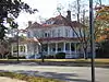 Savannah Avenue Historic District |
November 15, 1996 (#96001339) |
Along Savannah Ave. and E. Grady St. between S. Crescent Cir. 32°26′38″N 81°46′24″W |
Statesboro | |
| 16 | South Main Street Historic District | .jpg.webp) South Main Street Historic District |
September 6, 1989 (#89001160) |
Roughly S. Main St. between W. Main and Vine Sts. 32°26′55″N 81°47′00″W |
Statesboro | |
| 17 | South Main Street Residential Historic District | 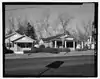 South Main Street Residential Historic District |
September 6, 1989 (#89001161) |
Roughly College Ln., Southern Railway right-of-way, Walnut, Mikell, and S. Main Sts. 32°26′25″N 81°47′01″W |
Statesboro | |
| 18 | Statesboro City Hall and Fire Station | September 6, 1989 (#89001162) |
Siebald and Courtland Sts. 32°26′59″N 81°46′56″W |
Statesboro | Demolished before 1997 | |
| 19 | Stewart Stores | 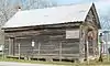 Stewart Stores |
May 20, 1993 (#93000430) |
Jct. of Railroad St. (Mullet Row) and Grady St. 32°32′18″N 81°55′55″W |
Portal | Only one of the stores is still there as of 2016. It is also known as the Portal Drugstore and is a Place in Peril. |
| 20 | Dr. James A. Stewart House | 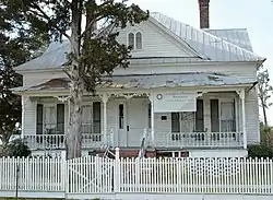 Dr. James A. Stewart House |
May 27, 1993 (#93000439) |
Grady St. 32°32′22″N 81°55′52″W |
Portal | |
| 21 | Upper Lott's Creek Primitive Baptist Church and Cemetery | 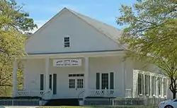 Upper Lott's Creek Primitive Baptist Church and Cemetery |
December 4, 2008 (#08000967) |
Metter-Portal Hwy. and Westside Rd. 32°29′17″N 81°58′23″W |
Metter | |
| 22 | US Post Office-Statesboro | 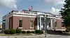 US Post Office-Statesboro |
September 6, 1989 (#89001163) |
26 S. Main St./US 301 32°26′52″N 81°47′00″W |
Statesboro | Was also used as City Hall. Currently houses offices of AgSouth Farm Credit |
| 23 | West Main Street Commercial Historic District | _(03).jpg.webp) West Main Street Commercial Historic District |
September 6, 1989 (#89001164) |
Roughly W. Main St. between Walnut and N. and S. Main Sts. 32°26′56″N 81°47′03″W |
Statesboro |
References
- "National Register of Historic Places: Weekly List Actions". National Park Service, United States Department of the Interior. Retrieved on February 5, 2021.
- Numbers represent an alphabetical ordering by significant words. Various colorings, defined here, differentiate National Historic Landmarks and historic districts from other NRHP buildings, structures, sites or objects.
- The eight-digit number below each date is the number assigned to each location in the National Register Information System database, which can be viewed by clicking the number.
| Wikimedia Commons has media related to National Register of Historic Places in Bulloch County, Georgia. |
| Topics | |
|---|---|
| Lists by state |
|
| Lists by insular areas | |
| Lists by associated state | |
| Other areas | |
| Related | |
| |
This article is issued from Wikipedia. The text is licensed under Creative Commons - Attribution - Sharealike. Additional terms may apply for the media files.